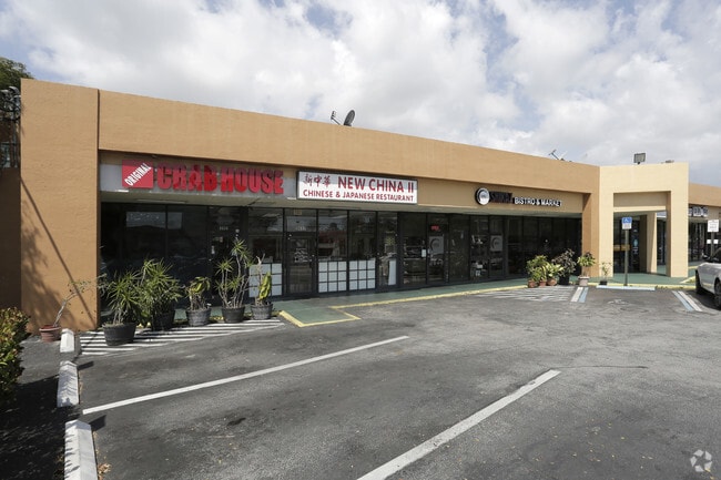
Property Record
9630 Sw 77Th Ave, Miami, FL 33156


NEARBY LISTINGS FOR SALE OR LEASE
Property Detail
9630 Sw 77Th Ave
30-5002-000-0740
2 55 40 .64 AC M/L BEG NW COR OF NW1/4 OF NW1/4 OF SW1/4 E19FT SELY 250.80FT E28.34FT SELY163.59FT W129.68FT N406.35FT TO POB LYG W OF PALMETTO RD LOT SIZE 27887 SQ FT COC 24850-1391 08 2006 4
Storemultistory
Miami/Dade
X
Florida
12086C0462L
0.64 AC
2024
Kendall
2025
South Florida
007809
Miami-Miami Beach-Kendall, FL
10,753 SF
DEMOGRAPHICS near 9630 Sw 77Th Ave
1 Mile
3 Mile
5 Mile
2024 Total Population
21,742
97,326
273,085
2029 Population
21,550
95,378
266,216
Pop Growth 2024-2029
(0.88%)
(2.00%)
(2.52%)
Average Age
42
42
43
2024 Total Households
10,017
38,135
98,539
HH Growth 2024-2029
(1.05%)
(2.17%)
(2.76%)
Median Household Inc
$71,281
$90,367
$85,440
Avg Household Size
2.10
2.50
2.60
2024 Avg HH Vehicles
2.00
2.00
2.00
Median Home Value
$523,492
$668,868
$497,107
Median Year Built
1978
1974
1973
Nearby Places
Map Layers
Map Styles
 Street
 Aerial
- Restaurants
- Banks
- Shops
- Fitness
- Groceries
PUBLIC TRANSPORTATION
TRANSIT/SUBWAY
Dadeland South (Metrorail Green Line - Miami-Dade Transit (Metrorail/Metromover))
DRIVE
WALK
Distance
Dadeland South (Metrorail Green Line - Miami-Dade Transit (Metrorail/Metromover))
2 min
11 min
0.6 mi
COMMUTER RAIL
Dadeland South (Metrorail Green Line - Miami-Dade Transit (Metrorail/Metromover))
DRIVE
WALK
Distance
Dadeland South (Metrorail Green Line - Miami-Dade Transit (Metrorail/Metromover))
2 min
14 min
0.7 mi
Dadeland North (Metrorail Green Line - Miami-Dade Transit (Metrorail/Metromover))
DRIVE
WALK
Distance
Dadeland North (Metrorail Green Line - Miami-Dade Transit (Metrorail/Metromover))
4 min
1.6 mi
AIRPORT
Miami International
DRIVE
WALK
Distance
Miami International
20 min
10.7 mi
Fort Lauderdale/Hollywood International
DRIVE
WALK
Distance
Fort Lauderdale/Hollywood International
51 min
33.5 mi
SALE & LEASE HISTORY
LISTING DATE
SALE/LEASE

Oct 17, 2019
For Lease
Apr 06, 2017
For Lease
Nearby Properties
Address
Land Use
TOTAL SIZE
Lot Size
Zoning
Address
Land Use
TOTAL SIZE
Lot Size
Zoning
2,238,641 SF
39 AC
6114
Address
Land Use
TOTAL SIZE
Lot Size
Zoning
1,018,683 SF
11.46 AC
5000
Address
Land Use
TOTAL SIZE
Lot Size
Zoning
1,527,515 SF
55.17 AC
5000
Address
Land Use
TOTAL SIZE
Lot Size
Zoning
877,136 SF
2.96 AC
6112
Address
Land Use
TOTAL SIZE
Lot Size
Zoning
766,093 SF
8.91 AC
5000
Address
Land Use
TOTAL SIZE
Lot Size
Zoning
764,501 SF
1.81 AC
6114
Address
Land Use
TOTAL SIZE
Lot Size
Zoning
644,929 SF
1.10 AC
6114
Address
Land Use
TOTAL SIZE
Lot Size
Zoning
759,863 SF
7.02 AC
6506
Address
Land Use
TOTAL SIZE
Lot Size
Zoning
846,804 SF
43 AC
6400
Address
Land Use
TOTAL SIZE
Lot Size
Zoning
634,144 SF
3.12 AC
6114
Address
Land Use
TOTAL SIZE
Lot Size
Zoning
521,667 SF
1.08 AC
6112
Address
Land Use
TOTAL SIZE
Lot Size
Zoning
532,779 SF
0000
Address
Land Use
TOTAL SIZE
Lot Size
Zoning
859,337 SF
0.13 AC
7100
Address
Land Use
TOTAL SIZE
Lot Size
Zoning
516,656 SF
9.65 AC
6300
Address
Land Use
TOTAL SIZE
Lot Size
Zoning
333,947 SF
21.32 AC
6400
Address
Land Use
TOTAL SIZE
Lot Size
Zoning
364,114 SF
20 AC
3100
Address
Land Use
TOTAL SIZE
Lot Size
Zoning
432,416 SF
1.67 AC
5004
Address
Land Use
TOTAL SIZE
Lot Size
Zoning
199,915 SF
15.19 AC
6200
Address
Land Use
TOTAL SIZE
Lot Size
Zoning
452,547 SF
0.90 AC
6114
Address
Land Use
TOTAL SIZE
Lot Size
Zoning
705,929 SF
7.05 AC
9600
Address
Land Use
TOTAL SIZE
Lot Size
Zoning
553,491 SF
10.64 AC
3900
Address
Land Use
TOTAL SIZE
Lot Size
Zoning
370,938 SF
1.58 AC
6112
Address
Land Use
TOTAL SIZE
Lot Size
Zoning
277,025 SF
0.01 AC
6114
Address
Land Use
TOTAL SIZE
Lot Size
Zoning
129,079 SF
4 AC
6114
Address
Land Use
TOTAL SIZE
Lot Size
Zoning
350,948 SF
22.42 AC
3800
Address
Land Use
TOTAL SIZE
Lot Size
Zoning
327,378 SF
0.14 AC
7600
Address
Land Use
TOTAL SIZE
Lot Size
Zoning
304,771 SF
1.81 AC
5003
Address
Land Use
TOTAL SIZE
Lot Size
Zoning
401,432 SF
4.63 AC
6111
Address
Land Use
TOTAL SIZE
Lot Size
Zoning
114,879 SF
7.60 AC
6114
Address
Land Use
TOTAL SIZE
Lot Size
Zoning
540,778 SF
0.01 AC
6114
The World's #1 Commercial Real Estate Marketplace
Connect with us
© 2025 CoStar Group
The information above has been obtained from sources believed reliable. While we do not doubt its accuracy we have not verified it and make no guarantee, warranty or representation about it. It is your responsibility to independently confirm its accuracy and completeness. Any projections, opinions, assumptions, or estimates used are for example only and do not represent the current or future performance of the property. The value of this transaction to you depends on tax and other factors which should be evaluated by your tax, financial, and legal advisors. You and your advisors should conduct a careful, independent investigation of the property to determine to your satisfaction the suitability of the property for your needs.