Property Record
9678 Railroad St, Elk Grove, CA 95624

NEARBY LISTINGS FOR SALE OR LEASE
Property Detail
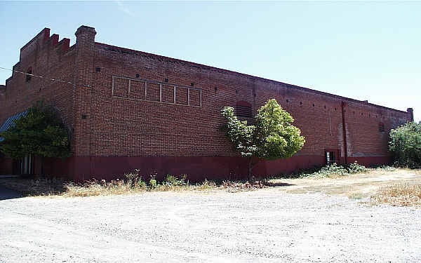
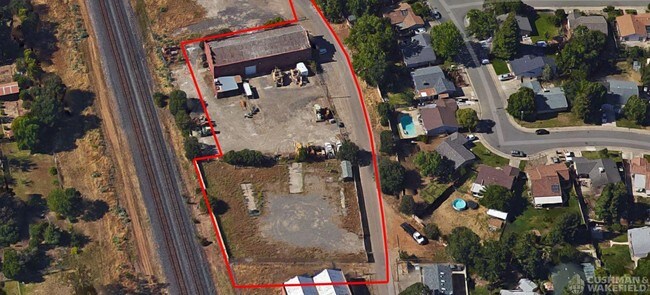
9678 Railroad St
Sacramento-Roseville-Folsom, CA
Elk Grove Warehouse
134-0050-052
POR OF SEC 6, T6N, R6E, MDB&M DESC AS SD POR BOUNDED N & EBY LANDS OF J. L. DA ROZA EST., ON S BY LAND OF M. L. HOOVEREST., AND W BY THE CENTRAL PACIFIC RR TOGETHER WITH S'LY 150 FTOF N'LY 351 FT OF SBE 872-34-21N-58. CONTG 28,306 SQ FT M/L
Apartment
Sacramento
X
California
06067C0338H
0.65 AC
2024
Elk Grove/Laguna
2025
Sacramento
009310
DEMOGRAPHICS near 9678 Railroad St
1 Mile
3 Mile
5 Mile
2024 Total Population
14,864
77,866
218,603
2029 Population
14,979
78,753
220,216
Pop Growth 2024-2029
+ 0.77%
+ 1.14%
+ 0.74%
Average Age
40
39
38
2024 Total Households
4,982
24,420
66,038
HH Growth 2024-2029
+ 0.60%
+ 1.09%
+ 0.70%
Median Household Inc
$101,507
$109,122
$103,289
Avg Household Size
2.90
3.10
3.20
2024 Avg HH Vehicles
2.00
2.00
2.00
Median Home Value
$488,007
$572,019
$508,310
Median Year Built
1983
1998
1998
Nearby Places
Map Layers
Map Styles
 Street
 Aerial
- Restaurants
- Banks
- Shops
- Fitness
- Groceries
PUBLIC TRANSPORTATION
AIRPORT
Sacramento International
DRIVE
WALK
Distance
Sacramento International
38 min
27.1 mi
Freight Ports
Port of Stockton
DRIVE
WALK
Distance
Port of Stockton
51 min
39.2 mi
SALE & LEASE HISTORY
LISTING DATE
SALE/LEASE

Sep 24, 2016
For Lease
Sep 24, 2016
For Sale
Nearby Properties
Address
Land Use
TOTAL SIZE
Lot Size
Zoning
Address
Land Use
TOTAL SIZE
Lot Size
Zoning
43.54 AC
LI
Address
Land Use
TOTAL SIZE
Lot Size
Zoning
7.65 AC
RD-20
Address
Land Use
TOTAL SIZE
Lot Size
Zoning
10.35 AC
SC
Address
Land Use
TOTAL SIZE
Lot Size
Zoning
43.06 AC
LRSPA
Address
Land Use
TOTAL SIZE
Lot Size
Zoning
221,556 SF
20.10 AC
HI
Address
Land Use
TOTAL SIZE
Lot Size
Zoning
102,085 SF
10.26 AC
BP
Address
Land Use
TOTAL SIZE
Lot Size
Zoning
147,920 SF
18.20 AC
SC
Address
Land Use
TOTAL SIZE
Lot Size
Zoning
152,217 SF
17.42 AC
SC
Address
Land Use
TOTAL SIZE
Lot Size
Zoning
9.02 AC
SPASEPA
Address
Land Use
TOTAL SIZE
Lot Size
Zoning
64,579 SF
5.41 AC
LRSPA
Address
Land Use
TOTAL SIZE
Lot Size
Zoning
242,577 SF
0.10 AC
RD-20
Address
Land Use
TOTAL SIZE
Lot Size
Zoning
105,511 SF
4.79 AC
BP
Address
Land Use
TOTAL SIZE
Lot Size
Zoning
105,511 SF
6.67 AC
BP
Address
Land Use
TOTAL SIZE
Lot Size
Zoning
111,489 SF
4.96 AC
MP
Address
Land Use
TOTAL SIZE
Lot Size
Zoning
195,101 SF
12.21 AC
BP
Address
Land Use
TOTAL SIZE
Lot Size
Zoning
76,090 SF
3.32 AC
RD-25
Address
Land Use
TOTAL SIZE
Lot Size
Zoning
108,843 SF
4.14 AC
RD-30
Address
Land Use
TOTAL SIZE
Lot Size
Zoning
110,372 SF
2.68 AC
BP
Address
Land Use
TOTAL SIZE
Lot Size
Zoning
102,526 SF
4.06 AC
MP
Address
Land Use
TOTAL SIZE
Lot Size
Zoning
100 SF
50.85 AC
LRSPA
Address
Land Use
TOTAL SIZE
Lot Size
Zoning
66,793 SF
2.48 AC
SC
Address
Land Use
TOTAL SIZE
Lot Size
Zoning
102,565 SF
4.38 AC
RD-25
Address
Land Use
TOTAL SIZE
Lot Size
Zoning
68,190 SF
3.75 AC
BP
Address
Land Use
TOTAL SIZE
Lot Size
Zoning
5.38 AC
SC
Address
Land Use
TOTAL SIZE
Lot Size
Zoning
42,890 SF
4.38 AC
MP
Address
Land Use
TOTAL SIZE
Lot Size
Zoning
71,987 SF
3.73 AC
BP
Address
Land Use
TOTAL SIZE
Lot Size
Zoning
63,550 SF
5.53 AC
AC
Address
Land Use
TOTAL SIZE
Lot Size
Zoning
21.18 AC
HI
Address
Land Use
TOTAL SIZE
Lot Size
Zoning
79,786 SF
26.39 AC
SC
Address
Land Use
TOTAL SIZE
Lot Size
Zoning
45,413 SF
7.31 AC
SC
The World's #1 Commercial Real Estate Marketplace
Connect with us
© 2026 CoStar Group
The information above has been obtained from sources believed reliable. While we do not doubt its accuracy we have not verified it and make no guarantee, warranty or representation about it. It is your responsibility to independently confirm its accuracy and completeness. Any projections, opinions, assumptions, or estimates used are for example only and do not represent the current or future performance of the property. The value of this transaction to you depends on tax and other factors which should be evaluated by your tax, financial, and legal advisors. You and your advisors should conduct a careful, independent investigation of the property to determine to your satisfaction the suitability of the property for your needs.