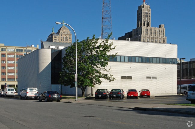
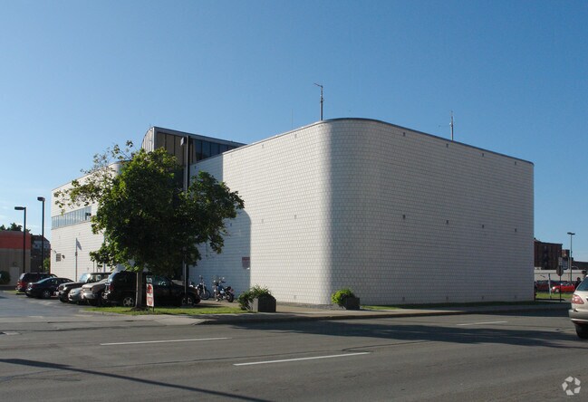
Property Record
98 E Eagle St, Buffalo, NY 14203

Property Detail
98 E Eagle St
140200-111-130-0012-005-110
EAST COR OAK IRR S/L & REAR LINE
Officebuilding
ERIE
N-1C
New York
B and X Area of moderate flood hazard, usually the area between the limits of the 100-year and 500-year floods.
5.110
0
0.34 AC
2025
Buffalo CBD
016500
Buffalo/Niagara Falls
28,133 SF
Buffalo-Cheektowaga, NY
NEARBY LISTINGS FOR SALE OR LEASE
DEMOGRAPHICS near 98 E Eagle St
1 mile
3 mile
5 mile
2025 Total Population
17,173
105,299
253,888
2030 Population
17,765
104,069
248,224
Pop Growth 2025-2030
+ 3.45%
(1.17%)
(2.23%)
Average Age
40
38
38
2025 Total Households
8,746
47,997
110,314
HH Growth 2025-2030
+ 3.30%
(0.92%)
(2.13%)
Median Household Inc
$32,111
$44,439
$48,780
Avg Household Size
1.80
2.10
2.20
2025 Avg HH Vehicles
1.00
1.00
1.00
Median Home Value
$260,544
$206,289
$176,016
Median Year Built
1958
1946
1946
Nearby Places
Map Layers
Map Styles
 Street
 Aerial
Transit
 Traffic
 Biking
Places
Listings with unknown addresses are not visible on the map
- Restaurants
- Banks
- Shops
- Fitness
- Groceries
PUBLIC TRANSPORTATION
COMMUTER RAIL
Drive
Walk
Distance
2 min
10 min
0.5 mi
AIRPORT
Buffalo Niagara International
Drive
Walk
Distance
Buffalo Niagara International
19 min
11.4 mi
Niagara Falls International
Drive
Walk
Distance
Niagara Falls International
31 min
20.4 mi
Nearby Properties
Address
Land Use
TOTAL SIZE
Lot Size
Zoning
Address
Land Use
TOTAL SIZE
Lot Size
Zoning
1,053,391 SF
88.26 AC
D-IL
Address
Land Use
TOTAL SIZE
Lot Size
Zoning
704,072 SF
8.61 AC
N-1C
Address
Land Use
TOTAL SIZE
Lot Size
Zoning
Address
Land Use
TOTAL SIZE
Lot Size
Zoning
686,000 SF
3.62 AC
N-2R
Address
Land Use
TOTAL SIZE
Lot Size
Zoning
870,511 SF
4.40 AC
D-M
Address
Land Use
TOTAL SIZE
Lot Size
Zoning
401,805 SF
2.04 AC
D-M
Address
Land Use
TOTAL SIZE
Lot Size
Zoning
251,908 SF
D-M
Address
Land Use
TOTAL SIZE
Lot Size
Zoning
658,732 SF
1.83 AC
N-1D
Address
Land Use
TOTAL SIZE
Lot Size
Zoning
896,000 SF
3.99 AC
N-1D
Address
Land Use
TOTAL SIZE
Lot Size
Zoning
89,496 SF
6.44 AC
D-R
Address
Land Use
TOTAL SIZE
Lot Size
Zoning
569,121 SF
1.04 AC
N-1D
Address
Land Use
TOTAL SIZE
Lot Size
Zoning
288,014 SF
3.68 AC
N-1C
Address
Land Use
TOTAL SIZE
Lot Size
Zoning
421,249 SF
10.62 AC
N-1D
Address
Land Use
TOTAL SIZE
Lot Size
Zoning
240,783 SF
1.63 AC
N-1D
Address
Land Use
TOTAL SIZE
Lot Size
Zoning
349,336 SF
2.70 AC
D-M
Address
Land Use
TOTAL SIZE
Lot Size
Zoning
12,641 SF
0.56 AC
N-2C
Address
Land Use
TOTAL SIZE
Lot Size
Zoning
465,720 SF
1.98 AC
N-1D
Address
Land Use
TOTAL SIZE
Lot Size
Zoning
156,870 SF
D-M
Address
Land Use
TOTAL SIZE
Lot Size
Zoning
321,589 SF
1.95 AC
N-1C
Address
Land Use
TOTAL SIZE
Lot Size
Zoning
7,752 SF
10.50 AC
D-R
Address
Land Use
TOTAL SIZE
Lot Size
Zoning
320,576 SF
1.90 AC
N-1S
Address
Land Use
TOTAL SIZE
Lot Size
Zoning
473,220 SF
8.18 AC
N-1C
Address
Land Use
TOTAL SIZE
Lot Size
Zoning
611,620 SF
2.20 AC
N-1S
Address
Land Use
TOTAL SIZE
Lot Size
Zoning
45,033 SF
1.18 AC
N-1C
Address
Land Use
TOTAL SIZE
Lot Size
Zoning
453,956 SF
1.09 AC
N-1D
Address
Land Use
TOTAL SIZE
Lot Size
Zoning
2,832 SF
2.54 AC
N-1C
Address
Land Use
TOTAL SIZE
Lot Size
Zoning
199,040 SF
2.24 AC
N-1D
Address
Land Use
TOTAL SIZE
Lot Size
Zoning
372,216 SF
2.17 AC
N-1D
Address
Land Use
TOTAL SIZE
Lot Size
Zoning
217,888 SF
4.39 AC
N-1D
Address
Land Use
TOTAL SIZE
Lot Size
Zoning
119,851 SF
1.35 AC
N-2R
The World's #1 Commercial Real Estate Marketplace
Connect with us
© 2026 CoStar Group
The information above has been obtained from sources believed reliable. While we do not doubt its accuracy we have not verified it and make no guarantee, warranty or representation about it. It is your responsibility to independently confirm its accuracy and completeness. Any projections, opinions, assumptions, or estimates used are for example only and do not represent the current or future performance of the property. The value of this transaction to you depends on tax and other factors which should be evaluated by your tax, financial, and legal advisors. You and your advisors should conduct a careful, independent investigation of the property to determine to your satisfaction the suitability of the property for your needs.