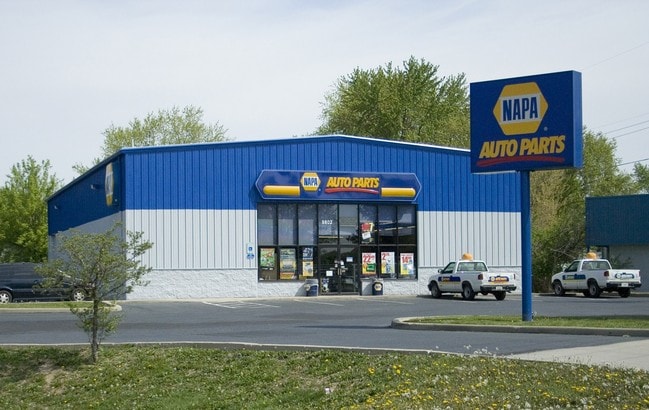
Property Record
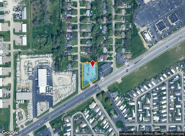
9802 Pendleton Pike, Indianapolis, IN 46236

NEARBY LISTINGS FOR SALE OR LEASE
Property Detail
9802 Pendleton Pike
Indianapolis-Carmel-Greenwood, IN
Anthony S La Pinta 1St Add
49-08-08-100-060.000-407
ANTHONY S LA PINTA 1ST ADD L33 & PT L34 BEG NE COR P.O.B. S89.79 SW174.3 N179.1 E150 TO BEG .722 AC
Storebuilding
Marion
X
Indiana
18097C0180F
33,34
2023
0.72 AC
2024
Lawrence/East County
330702
Indianapolis
6,000 SF
DEMOGRAPHICS near 9802 Pendleton Pike
1 mile
3 mile
5 mile
2024 Total Population
9,207
72,238
172,281
2029 Population
9,135
71,591
170,941
Pop Growth 2024-2029
(0.78%)
(0.90%)
(0.78%)
Average Age
37
35
37
2024 Total Households
3,665
27,112
67,168
HH Growth 2024-2029
(0.44%)
(0.88%)
(0.84%)
Median Household Inc
$46,969
$51,254
$59,671
Avg Household Size
2.50
2.60
2.50
2024 Avg HH Vehicles
2.00
2.00
2.00
Median Home Value
$71,243
$157,398
$184,652
Median Year Built
1994
1978
1978
Nearby Places
Map Layers
Map Styles
 Street
 Aerial
Transit
 Traffic
 Biking
Places
Listings with unknown addresses are not visible on the map
- Restaurants
- Banks
- Shops
- Fitness
- Groceries
PUBLIC TRANSPORTATION
AIRPORT
Indianapolis International
Drive
Walk
Distance
Indianapolis International
45 min
25.6 mi
Nearby Properties
Address
Land Use
TOTAL SIZE
Lot Size
Zoning
Address
Land Use
TOTAL SIZE
Lot Size
Zoning
11,154 SF
21.99 AC
Address
Land Use
TOTAL SIZE
Lot Size
Zoning
532,932 SF
61.88 AC
ZO03
Address
Land Use
TOTAL SIZE
Lot Size
Zoning
2,556 SF
35.56 AC
ZO01
Address
Land Use
TOTAL SIZE
Lot Size
Zoning
4,217 SF
7.37 AC
ZO01
Address
Land Use
TOTAL SIZE
Lot Size
Zoning
129,608 SF
54.85 AC
ZO01
Address
Land Use
TOTAL SIZE
Lot Size
Zoning
679,214 SF
16.70 AC
ZO01
Address
Land Use
TOTAL SIZE
Lot Size
Zoning
13,087 SF
57.88 AC
Address
Land Use
TOTAL SIZE
Lot Size
Zoning
136,336 SF
8.74 AC
ZO01
Address
Land Use
TOTAL SIZE
Lot Size
Zoning
6,770 SF
38.91 AC
Address
Land Use
TOTAL SIZE
Lot Size
Zoning
293,952 SF
12.88 AC
ZO01
Address
Land Use
TOTAL SIZE
Lot Size
Zoning
65,095 SF
4.06 AC
ZO01
Address
Land Use
TOTAL SIZE
Lot Size
Zoning
1,066 SF
24.93 AC
Address
Land Use
TOTAL SIZE
Lot Size
Zoning
31.13 AC
Address
Land Use
TOTAL SIZE
Lot Size
Zoning
118,126 SF
6.31 AC
ZO01
Address
Land Use
TOTAL SIZE
Lot Size
Zoning
167,808 SF
14.95 AC
ZO01
Address
Land Use
TOTAL SIZE
Lot Size
Zoning
109,200 SF
4.63 AC
ZO01
Address
Land Use
TOTAL SIZE
Lot Size
Zoning
329,180 SF
20.88 AC
Address
Land Use
TOTAL SIZE
Lot Size
Zoning
203,720 SF
21.44 AC
Address
Land Use
TOTAL SIZE
Lot Size
Zoning
1,490 SF
14.21 AC
ZO01
Address
Land Use
TOTAL SIZE
Lot Size
Zoning
4,754 SF
16.85 AC
ZO01
Address
Land Use
TOTAL SIZE
Lot Size
Zoning
278,338 SF
14.80 AC
Address
Land Use
TOTAL SIZE
Lot Size
Zoning
4,878 SF
25.65 AC
Address
Land Use
TOTAL SIZE
Lot Size
Zoning
206,080 SF
12.97 AC
ZO01
Address
Land Use
TOTAL SIZE
Lot Size
Zoning
175,046 SF
15.77 AC
ZO01
Address
Land Use
TOTAL SIZE
Lot Size
Zoning
640 SF
26.44 AC
Address
Land Use
TOTAL SIZE
Lot Size
Zoning
60,640 SF
13.76 AC
Address
Land Use
TOTAL SIZE
Lot Size
Zoning
3,004 SF
13.79 AC
Address
Land Use
TOTAL SIZE
Lot Size
Zoning
128,126 SF
12.99 AC
ZO01
Address
Land Use
TOTAL SIZE
Lot Size
Zoning
33,588 SF
3.06 AC
ZO01
Address
Land Use
TOTAL SIZE
Lot Size
Zoning
33,346 SF
10.10 AC
ZO01
The World's #1 Commercial Real Estate Marketplace
Connect with us
© 2026 CoStar Group
The information above has been obtained from sources believed reliable. While we do not doubt its accuracy we have not verified it and make no guarantee, warranty or representation about it. It is your responsibility to independently confirm its accuracy and completeness. Any projections, opinions, assumptions, or estimates used are for example only and do not represent the current or future performance of the property. The value of this transaction to you depends on tax and other factors which should be evaluated by your tax, financial, and legal advisors. You and your advisors should conduct a careful, independent investigation of the property to determine to your satisfaction the suitability of the property for your needs.