Property Record
9826 Clay Rd, Houston, TX 77080


NEARBY LISTINGS FOR SALE OR LEASE
Property Detail
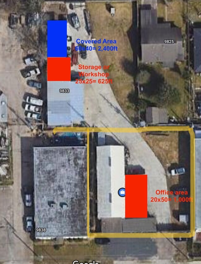
9826 Clay Rd
Houston-The Woodlands-Sugar Land, TX
Spring Branch Acres
0802050000017
LTS 17 & 18 BLK C SPRING BRANCH ACRES
Storebuilding
Harris
X
Texas
48201C0635M
17,18
2024
0.36 AC
2025
Northwest Inner Loop
521600
Houston
7,206 SF
DEMOGRAPHICS near 9826 Clay Rd
1 Mile
3 Mile
5 Mile
2024 Total Population
17,886
110,417
283,945
2029 Population
18,626
113,406
290,544
Pop Growth 2024-2029
+ 4.14%
+ 2.71%
+ 2.32%
Average Age
38
36
37
2024 Total Households
6,664
39,460
104,077
HH Growth 2024-2029
+ 4.46%
+ 2.70%
+ 2.38%
Median Household Inc
$61,639
$51,972
$64,384
Avg Household Size
2.60
2.70
2.60
2024 Avg HH Vehicles
2.00
2.00
2.00
Median Home Value
$277,887
$276,298
$312,382
Median Year Built
1976
1976
1978
Nearby Places
Map Layers
Map Styles
 Street
 Aerial
- Restaurants
- Banks
- Shops
- Fitness
- Groceries
PUBLIC TRANSPORTATION
AIRPORT
George Bush Intcntl/Houston
DRIVE
WALK
Distance
George Bush Intcntl/Houston
32 min
25.3 mi
William P Hobby
DRIVE
WALK
Distance
William P Hobby
43 min
27.2 mi
Freight Ports
Port of Houston
DRIVE
WALK
Distance
Port of Houston
35 min
22.8 mi
SALE & LEASE HISTORY
LISTING DATE
SALE/LEASE

Jan 24, 2024
For Lease
Nearby Properties
Address
Land Use
TOTAL SIZE
Lot Size
Zoning
Address
Land Use
TOTAL SIZE
Lot Size
Zoning
578,530 SF
32.81 AC
Address
Land Use
TOTAL SIZE
Lot Size
Zoning
793,669 SF
121.83 AC
Address
Land Use
TOTAL SIZE
Lot Size
Zoning
504,256 SF
6.09 AC
Address
Land Use
TOTAL SIZE
Lot Size
Zoning
519,220 SF
6.23 AC
Address
Land Use
TOTAL SIZE
Lot Size
Zoning
350,655 SF
16.76 AC
Address
Land Use
TOTAL SIZE
Lot Size
Zoning
643,804 SF
31.40 AC
Address
Land Use
TOTAL SIZE
Lot Size
Zoning
342,163 SF
8.50 AC
Address
Land Use
TOTAL SIZE
Lot Size
Zoning
427,921 SF
18.14 AC
Address
Land Use
TOTAL SIZE
Lot Size
Zoning
336,681 SF
16.10 AC
Address
Land Use
TOTAL SIZE
Lot Size
Zoning
Address
Land Use
TOTAL SIZE
Lot Size
Zoning
293,407 SF
9.19 AC
Address
Land Use
TOTAL SIZE
Lot Size
Zoning
300,348 SF
6.10 AC
Address
Land Use
TOTAL SIZE
Lot Size
Zoning
456,294 SF
19.02 AC
Address
Land Use
TOTAL SIZE
Lot Size
Zoning
647,228 SF
9.85 AC
Address
Land Use
TOTAL SIZE
Lot Size
Zoning
408,730 SF
24.68 AC
Address
Land Use
TOTAL SIZE
Lot Size
Zoning
802,913 SF
27.11 AC
Address
Land Use
TOTAL SIZE
Lot Size
Zoning
281,843 SF
13.97 AC
Address
Land Use
TOTAL SIZE
Lot Size
Zoning
312,065 SF
17.83 AC
Address
Land Use
TOTAL SIZE
Lot Size
Zoning
157,698 SF
5.98 AC
Address
Land Use
TOTAL SIZE
Lot Size
Zoning
387,788 SF
17.95 AC
Address
Land Use
TOTAL SIZE
Lot Size
Zoning
426,748 SF
26.09 AC
Address
Land Use
TOTAL SIZE
Lot Size
Zoning
229,369 SF
4 AC
Address
Land Use
TOTAL SIZE
Lot Size
Zoning
401,600 SF
20.48 AC
Address
Land Use
TOTAL SIZE
Lot Size
Zoning
172,326 SF
8.07 AC
Address
Land Use
TOTAL SIZE
Lot Size
Zoning
350,057 SF
19.96 AC
Address
Land Use
TOTAL SIZE
Lot Size
Zoning
409,271 SF
20.70 AC
Address
Land Use
TOTAL SIZE
Lot Size
Zoning
Address
Land Use
TOTAL SIZE
Lot Size
Zoning
447,480 SF
18.48 AC
Address
Land Use
TOTAL SIZE
Lot Size
Zoning
185,252 SF
17.14 AC
Address
Land Use
TOTAL SIZE
Lot Size
Zoning
287,212 SF
12.52 AC
The World's #1 Commercial Real Estate Marketplace
Connect with us
© 2026 CoStar Group
The information above has been obtained from sources believed reliable. While we do not doubt its accuracy we have not verified it and make no guarantee, warranty or representation about it. It is your responsibility to independently confirm its accuracy and completeness. Any projections, opinions, assumptions, or estimates used are for example only and do not represent the current or future performance of the property. The value of this transaction to you depends on tax and other factors which should be evaluated by your tax, financial, and legal advisors. You and your advisors should conduct a careful, independent investigation of the property to determine to your satisfaction the suitability of the property for your needs.