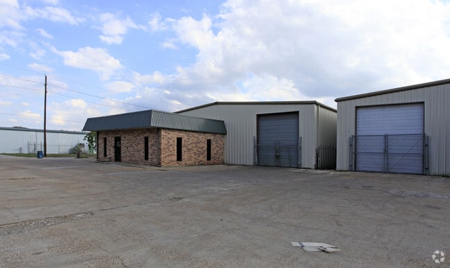
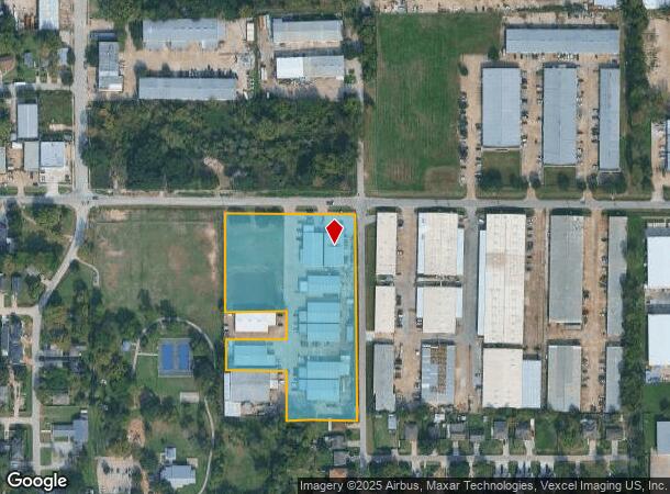
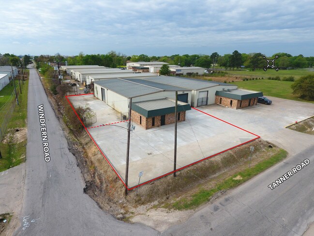
Property Record
9901 Tanner Rd, Houston, TX 77041
NEARBY LISTINGS FOR SALE OR LEASE
Property Detail
9901 Tanner Rd
0131810000035
Fairbanks Sec 1
Outdoorrecreationbeachmountaindesert
TRS 13B 13B-2 & 13C BLK 13 FAIRBANKS SEC 1
X
Harris
48201C0635M
Texas
2024
4.87 AC
2025
Northwest Inner Loop
521600
Houston
51,396 SF
Houston-The Woodlands-Sugar Land, TX
DEMOGRAPHICS near 9901 Tanner Rd
1 Mile
3 Mile
5 Mile
2024 Total Population
4,692
91,039
277,276
2029 Population
4,800
93,145
283,065
Pop Growth 2024-2029
+ 2.30%
+ 2.31%
+ 2.09%
Average Age
37
36
37
2024 Total Households
1,478
32,366
100,326
HH Growth 2024-2029
+ 2.10%
+ 2.26%
+ 2.13%
Median Household Inc
$57,321
$57,622
$59,541
Avg Household Size
3.00
2.70
2.70
2024 Avg HH Vehicles
2.00
2.00
2.00
Median Home Value
$203,894
$243,339
$262,168
Median Year Built
1989
1979
1981
Nearby Places
Map Layers
Map Styles
 Street
 Aerial
- Restaurants
- Banks
- Shops
- Fitness
- Groceries
PUBLIC TRANSPORTATION
AIRPORT
George Bush Intcntl/Houston
DRIVE
WALK
Distance
George Bush Intcntl/Houston
30 min
22.9 mi
William P Hobby
DRIVE
WALK
Distance
William P Hobby
44 min
27.7 mi
Freight Ports
Port of Houston
DRIVE
WALK
Distance
Port of Houston
35 min
23.3 mi
SALE & LEASE HISTORY
LISTING DATE
SALE/LEASE

Nov 09, 2021
For Lease
Nearby Properties
Address
Land Use
TOTAL SIZE
Lot Size
Zoning
Address
Land Use
TOTAL SIZE
Lot Size
Zoning
578,530 SF
32.81 AC
Address
Land Use
TOTAL SIZE
Lot Size
Zoning
793,669 SF
121.83 AC
Address
Land Use
TOTAL SIZE
Lot Size
Zoning
643,804 SF
31.40 AC
Address
Land Use
TOTAL SIZE
Lot Size
Zoning
342,163 SF
8.50 AC
Address
Land Use
TOTAL SIZE
Lot Size
Zoning
427,921 SF
18.14 AC
Address
Land Use
TOTAL SIZE
Lot Size
Zoning
336,681 SF
16.10 AC
Address
Land Use
TOTAL SIZE
Lot Size
Zoning
456,294 SF
19.02 AC
Address
Land Use
TOTAL SIZE
Lot Size
Zoning
647,228 SF
9.85 AC
Address
Land Use
TOTAL SIZE
Lot Size
Zoning
408,730 SF
24.68 AC
Address
Land Use
TOTAL SIZE
Lot Size
Zoning
802,913 SF
27.11 AC
Address
Land Use
TOTAL SIZE
Lot Size
Zoning
281,843 SF
13.97 AC
Address
Land Use
TOTAL SIZE
Lot Size
Zoning
312,065 SF
17.83 AC
Address
Land Use
TOTAL SIZE
Lot Size
Zoning
157,698 SF
5.98 AC
Address
Land Use
TOTAL SIZE
Lot Size
Zoning
426,748 SF
26.09 AC
Address
Land Use
TOTAL SIZE
Lot Size
Zoning
401,600 SF
20.48 AC
Address
Land Use
TOTAL SIZE
Lot Size
Zoning
172,326 SF
8.07 AC
Address
Land Use
TOTAL SIZE
Lot Size
Zoning
350,057 SF
19.96 AC
Address
Land Use
TOTAL SIZE
Lot Size
Zoning
409,271 SF
20.70 AC
Address
Land Use
TOTAL SIZE
Lot Size
Zoning
Address
Land Use
TOTAL SIZE
Lot Size
Zoning
347,694 SF
17.61 AC
Address
Land Use
TOTAL SIZE
Lot Size
Zoning
447,480 SF
18.48 AC
Address
Land Use
TOTAL SIZE
Lot Size
Zoning
185,252 SF
17.14 AC
Address
Land Use
TOTAL SIZE
Lot Size
Zoning
287,212 SF
12.52 AC
Address
Land Use
TOTAL SIZE
Lot Size
Zoning
472,988 SF
9 AC
Address
Land Use
TOTAL SIZE
Lot Size
Zoning
212,017 SF
14.11 AC
Address
Land Use
TOTAL SIZE
Lot Size
Zoning
251,461 SF
21.74 AC
Address
Land Use
TOTAL SIZE
Lot Size
Zoning
418,892 SF
19.81 AC
Address
Land Use
TOTAL SIZE
Lot Size
Zoning
358,361 SF
11.35 AC
Address
Land Use
TOTAL SIZE
Lot Size
Zoning
403,200 SF
20.53 AC
Address
Land Use
TOTAL SIZE
Lot Size
Zoning
272,209 SF
18.15 AC
The World's #1 Commercial Real Estate Marketplace
Connect with us
© 2025 CoStar Group
The information above has been obtained from sources believed reliable. While we do not doubt its accuracy we have not verified it and make no guarantee, warranty or representation about it. It is your responsibility to independently confirm its accuracy and completeness. Any projections, opinions, assumptions, or estimates used are for example only and do not represent the current or future performance of the property. The value of this transaction to you depends on tax and other factors which should be evaluated by your tax, financial, and legal advisors. You and your advisors should conduct a careful, independent investigation of the property to determine to your satisfaction the suitability of the property for your needs.