No Photo
Property Record
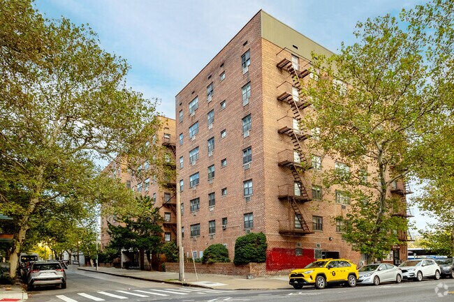
9910 60Th Ave, Corona, NY 11368


Property Detail
9910 60Th Ave
01948-0001
Queens 02 Ward
Cooperative
Queens
X
New York
3604970226F
1
2024
0.52 AC
2025
Corona
043702
Long Island (New York)
74,300 SF
New York-Jersey City-White Plains, NY-NJ
NEARBY LISTINGS FOR SALE OR LEASE
DEMOGRAPHICS near 9910 60Th Ave
1 mile
3 mile
5 mile
2024 Total Population
174,114
894,346
2,007,887
2029 Population
163,880
839,669
1,875,098
Pop Growth 2024-2029
(5.88%)
(6.11%)
(6.61%)
Average Age
41
42
40
2024 Total Households
62,851
316,101
716,599
HH Growth 2024-2029
(5.73%)
(6.17%)
(6.71%)
Median Household Inc
$68,116
$67,967
$71,267
Avg Household Size
2.70
2.70
2.70
2024 Avg HH Vehicles
1.00
1.00
1.00
Median Home Value
$559,704
$639,967
$702,745
Median Year Built
1958
1954
1951
Nearby Places
Map Layers
Map Styles
 Street
 Aerial
Transit
 Traffic
 Biking
Places
Listings with unknown addresses are not visible on the map
- Restaurants
- Banks
- Shops
- Fitness
- Groceries
PUBLIC TRANSPORTATION
TRANSIT/SUBWAY
63 Drive-Rego Park (E - New York MTA Subway (The Subway), M - New York MTA Subway (The Subway), R - New York MTA Subway (The Subway))
Drive
Walk
Distance
63 Drive-Rego Park (E - New York MTA Subway (The Subway), M - New York MTA Subway (The Subway), R - New York MTA Subway (The Subway))
3 min
13 min
0.7 mi
Woodhaven Boulevard (E,G,R Line) (E - New York MTA Subway (The Subway), M - New York MTA Subway (The Subway), R - New York MTA Subway (The Subway))
Drive
Walk
Distance
Woodhaven Boulevard (E,G,R Line) (E - New York MTA Subway (The Subway), M - New York MTA Subway (The Subway), R - New York MTA Subway (The Subway))
3 min
14 min
0.8 mi
67 Avenue (E - New York MTA Subway (The Subway), M - New York MTA Subway (The Subway), R - New York MTA Subway (The Subway))
Drive
Walk
Distance
67 Avenue (E - New York MTA Subway (The Subway), M - New York MTA Subway (The Subway), R - New York MTA Subway (The Subway))
6 min
16 min
0.9 mi
COMMUTER RAIL
Forest Hills Station (Babylon Branch - Long Island Rail Road, Hempstead Branch - Long Island Rail Road, Long Beach Branch - Long Island Rail Road, Port Jefferson Branch - Long Island Rail Road)
Drive
Walk
Distance
Forest Hills Station (Babylon Branch - Long Island Rail Road, Hempstead Branch - Long Island Rail Road, Long Beach Branch - Long Island Rail Road, Port Jefferson Branch - Long Island Rail Road)
7 min
2.3 mi
Mets-Willets Point Station (Port Washington Branch - Long Island Rail Road)
Drive
Walk
Distance
Mets-Willets Point Station (Port Washington Branch - Long Island Rail Road)
9 min
3.3 mi
AIRPORT
LaGuardia
Drive
Walk
Distance
LaGuardia
10 min
3.6 mi
John F Kennedy International
Drive
Walk
Distance
John F Kennedy International
16 min
10.3 mi
Newark Liberty International
Drive
Walk
Distance
Newark Liberty International
33 min
22.0 mi
Freight Ports
NY - Red Hook Container Terminal
Drive
Walk
Distance
NY - Red Hook Container Terminal
19 min
10.8 mi
Nearby Properties
Address
Land Use
TOTAL SIZE
Lot Size
Zoning
Address
Land Use
TOTAL SIZE
Lot Size
Zoning
2,078,606 SF
58.93 AC
R4
Address
Land Use
TOTAL SIZE
Lot Size
Zoning
1,258,350 SF
410.24 AC
PARK
Address
Land Use
TOTAL SIZE
Lot Size
Zoning
1,502,532 SF
6.35 AC
R7B
Address
Land Use
TOTAL SIZE
Lot Size
Zoning
772,163 SF
5.24 AC
C4-5X
Address
Land Use
TOTAL SIZE
Lot Size
Zoning
54,170 SF
229.57 AC
PARK
Address
Land Use
TOTAL SIZE
Lot Size
Zoning
1,292,074 SF
C4-2F
Address
Land Use
TOTAL SIZE
Lot Size
Zoning
234,891 SF
3.17 AC
C4-5X
Address
Land Use
TOTAL SIZE
Lot Size
Zoning
1,516,458 SF
5.97 AC
R7-1
Address
Land Use
TOTAL SIZE
Lot Size
Zoning
8.28 AC
R7-1
Address
Land Use
TOTAL SIZE
Lot Size
Zoning
8.28 AC
R7-1
Address
Land Use
TOTAL SIZE
Lot Size
Zoning
8.28 AC
R7-1
Address
Land Use
TOTAL SIZE
Lot Size
Zoning
15,000 SF
255.27 AC
PARK
Address
Land Use
TOTAL SIZE
Lot Size
Zoning
126.85 AC
PARK
Address
Land Use
TOTAL SIZE
Lot Size
Zoning
743,160 SF
11.73 AC
R5
Address
Land Use
TOTAL SIZE
Lot Size
Zoning
743,160 SF
11.73 AC
R5
Address
Land Use
TOTAL SIZE
Lot Size
Zoning
743,160 SF
11.73 AC
R5
Address
Land Use
TOTAL SIZE
Lot Size
Zoning
743,160 SF
11.73 AC
R5
Address
Land Use
TOTAL SIZE
Lot Size
Zoning
743,160 SF
11.73 AC
R5
Address
Land Use
TOTAL SIZE
Lot Size
Zoning
743,160 SF
11.73 AC
R5
Address
Land Use
TOTAL SIZE
Lot Size
Zoning
743,160 SF
11.73 AC
R5
Address
Land Use
TOTAL SIZE
Lot Size
Zoning
743,160 SF
11.73 AC
R5
Address
Land Use
TOTAL SIZE
Lot Size
Zoning
743,160 SF
11.73 AC
R5
Address
Land Use
TOTAL SIZE
Lot Size
Zoning
743,160 SF
11.73 AC
R5
Address
Land Use
TOTAL SIZE
Lot Size
Zoning
743,160 SF
11.73 AC
R5
Address
Land Use
TOTAL SIZE
Lot Size
Zoning
743,160 SF
11.73 AC
R5
Address
Land Use
TOTAL SIZE
Lot Size
Zoning
743,160 SF
11.73 AC
R5
Address
Land Use
TOTAL SIZE
Lot Size
Zoning
743,160 SF
11.73 AC
R5
Address
Land Use
TOTAL SIZE
Lot Size
Zoning
743,160 SF
11.73 AC
R5
Address
Land Use
TOTAL SIZE
Lot Size
Zoning
743,160 SF
11.73 AC
R5
Address
Land Use
TOTAL SIZE
Lot Size
Zoning
743,160 SF
11.73 AC
R5
The World's #1 Commercial Real Estate Marketplace
Connect with us
© 2026 CoStar Group
The information above has been obtained from sources believed reliable. While we do not doubt its accuracy we have not verified it and make no guarantee, warranty or representation about it. It is your responsibility to independently confirm its accuracy and completeness. Any projections, opinions, assumptions, or estimates used are for example only and do not represent the current or future performance of the property. The value of this transaction to you depends on tax and other factors which should be evaluated by your tax, financial, and legal advisors. You and your advisors should conduct a careful, independent investigation of the property to determine to your satisfaction the suitability of the property for your needs.