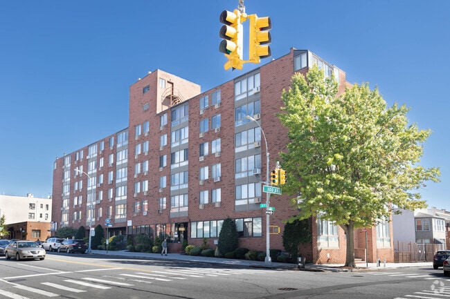
Property Record
9921 4Th Ave, Brooklyn, NY 11209
Current Lease Availabilities
NEARBY LISTINGS FOR SALE OR LEASE
Property Detail
9921 4Th Ave
New York-Jersey City-White Plains, NY-NJ
Harbour At Bay Ridge
06135-1019
DOCID-2023073100519002
Condominium
Kings
X
New York
3604970331F
1019
2024
0.50 AC
2025
Bay Ridge
016200
Long Island (New York)
919 SF
DEMOGRAPHICS near 9921 4Th Ave
1 mile
3 mile
5 mile
2024 Total Population
42,843
525,065
1,287,764
2029 Population
40,285
485,299
1,212,112
Pop Growth 2024-2029
(5.97%)
(7.57%)
(5.87%)
Average Age
43
39
40
2024 Total Households
18,816
172,357
451,151
HH Growth 2024-2029
(6.38%)
(7.85%)
(6.10%)
Median Household Inc
$80,049
$62,004
$67,774
Avg Household Size
2.20
2.90
2.70
2024 Avg HH Vehicles
1.00
1.00
1.00
Median Home Value
$837,003
$832,449
$797,995
Median Year Built
1947
1947
1948
Nearby Places
Map Layers
Map Styles
 Street
 Aerial
Transit
 Traffic
 Biking
Places
Listings with unknown addresses are not visible on the map
- Restaurants
- Banks
- Shops
- Fitness
- Groceries
PUBLIC TRANSPORTATION
TRANSIT/SUBWAY
Bay Ridge-95 Street (R - New York MTA Subway (The Subway))
Drive
Walk
Distance
Bay Ridge-95 Street (R - New York MTA Subway (The Subway))
1 min
6 min
0.3 mi
86 Street (R Line) (R - New York MTA Subway (The Subway))
Drive
Walk
Distance
86 Street (R Line) (R - New York MTA Subway (The Subway))
2 min
15 min
0.7 mi
COMMUTER RAIL
Grasmere (Staten Island Railway - New York MTA Subway (The Subway))
Drive
Walk
Distance
Grasmere (Staten Island Railway - New York MTA Subway (The Subway))
9 min
4.4 mi
Clifton (Staten Island Railway - New York MTA Subway (The Subway))
Drive
Walk
Distance
Clifton (Staten Island Railway - New York MTA Subway (The Subway))
10 min
4.9 mi
AIRPORT
LaGuardia
Drive
Walk
Distance
LaGuardia
31 min
17.4 mi
Newark Liberty International
Drive
Walk
Distance
Newark Liberty International
31 min
19.6 mi
John F Kennedy International
Drive
Walk
Distance
John F Kennedy International
28 min
19.6 mi
Freight Ports
NY - Red Hook Container Terminal
Drive
Walk
Distance
NY - Red Hook Container Terminal
11 min
6.3 mi
Nearby Properties
Address
Land Use
TOTAL SIZE
Lot Size
Zoning
Address
Land Use
TOTAL SIZE
Lot Size
Zoning
1,524,659 SF
170.96 AC
R4
Address
Land Use
TOTAL SIZE
Lot Size
Zoning
965,600 SF
6.65 AC
R5
Address
Land Use
TOTAL SIZE
Lot Size
Zoning
460,000 SF
3.21 AC
R6
Address
Land Use
TOTAL SIZE
Lot Size
Zoning
305,093 SF
0.60 AC
C1-9
Address
Land Use
TOTAL SIZE
Lot Size
Zoning
335,800 SF
1.51 AC
R6
Address
Land Use
TOTAL SIZE
Lot Size
Zoning
340,837 SF
0.61 AC
C1-9
Address
Land Use
TOTAL SIZE
Lot Size
Zoning
397,354 SF
0.61 AC
C5-2
Address
Land Use
TOTAL SIZE
Lot Size
Zoning
340,068 SF
0.58 AC
C2-8
Address
Land Use
TOTAL SIZE
Lot Size
Zoning
340,068 SF
0.58 AC
C2-8
Address
Land Use
TOTAL SIZE
Lot Size
Zoning
236,591 SF
207.66 AC
R3-2
Address
Land Use
TOTAL SIZE
Lot Size
Zoning
537,885 SF
2.98 AC
R8
Address
Land Use
TOTAL SIZE
Lot Size
Zoning
808,372 SF
0.18 AC
R6
Address
Land Use
TOTAL SIZE
Lot Size
Zoning
5,359,400 SF
59.07 AC
M2-1
Address
Land Use
TOTAL SIZE
Lot Size
Zoning
286,000 SF
12.63 AC
PARK
Address
Land Use
TOTAL SIZE
Lot Size
Zoning
370,248 SF
0.52 AC
C1-9
Address
Land Use
TOTAL SIZE
Lot Size
Zoning
418,000 SF
0.78 AC
R10A
Address
Land Use
TOTAL SIZE
Lot Size
Zoning
301,400 SF
22.27 AC
M3-1
Address
Land Use
TOTAL SIZE
Lot Size
Zoning
310,068 SF
0.58 AC
C2-8
Address
Land Use
TOTAL SIZE
Lot Size
Zoning
421,800 SF
2.35 AC
R6
Address
Land Use
TOTAL SIZE
Lot Size
Zoning
421,800 SF
2.35 AC
R6
Address
Land Use
TOTAL SIZE
Lot Size
Zoning
421,800 SF
2.35 AC
R6
Address
Land Use
TOTAL SIZE
Lot Size
Zoning
139,557 SF
11.47 AC
M1-1
Address
Land Use
TOTAL SIZE
Lot Size
Zoning
171,591 SF
0.14 AC
C5-2
Address
Land Use
TOTAL SIZE
Lot Size
Zoning
305,093 SF
0.60 AC
C1-9
Address
Land Use
TOTAL SIZE
Lot Size
Zoning
581,250 SF
3.22 AC
M3-1
Address
Land Use
TOTAL SIZE
Lot Size
Zoning
112,900 SF
0.22 AC
R10A
Address
Land Use
TOTAL SIZE
Lot Size
Zoning
369,046 SF
2.11 AC
R6A
Address
Land Use
TOTAL SIZE
Lot Size
Zoning
369,046 SF
2.11 AC
R6A
Address
Land Use
TOTAL SIZE
Lot Size
Zoning
369,046 SF
2.11 AC
R6A
Address
Land Use
TOTAL SIZE
Lot Size
Zoning
369,046 SF
2.11 AC
R6A
The World's #1 Commercial Real Estate Marketplace
Connect with us
© 2026 CoStar Group
The information above has been obtained from sources believed reliable. While we do not doubt its accuracy we have not verified it and make no guarantee, warranty or representation about it. It is your responsibility to independently confirm its accuracy and completeness. Any projections, opinions, assumptions, or estimates used are for example only and do not represent the current or future performance of the property. The value of this transaction to you depends on tax and other factors which should be evaluated by your tax, financial, and legal advisors. You and your advisors should conduct a careful, independent investigation of the property to determine to your satisfaction the suitability of the property for your needs.