Property Record
9949 W 80Th Ave, Arvada, CO 80005
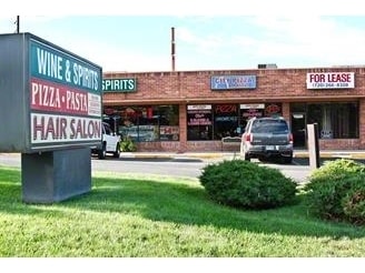


Property Detail
9949 W 80Th Ave
Denver-Aurora-Centennial, CO
SECTION 27 TOWNSHIP 02 RANGE 69 QTR SW SUBDIVISIONCD 235800 SUBDIVISIONNAME FABRY MINOR SUBDIVISION BLOCK LOT 000B SIZE: 28109 TRACT VALUE: .645
29-273-17-080
Jefferson
Commercialnec
Colorado
B and X Area of moderate flood hazard, usually the area between the limits of the 100-year and 500-year floods.
b
2025
0.65 AC
2025
Northwest
009835
Denver
5,289 SF
NEARBY LISTINGS FOR SALE OR LEASE
DEMOGRAPHICS near 9949 W 80Th Ave
1 mile
3 mile
5 mile
2025 Total Population
10,552
102,993
244,170
2030 Population
10,361
101,889
245,447
Pop Growth 2025-2030
(1.81%)
(1.07%)
+ 0.52%
Average Age
44
42
41
2025 Total Households
4,169
41,142
97,790
HH Growth 2025-2030
(1.94%)
(1.11%)
+ 0.54%
Median Household Inc
$131,535
$105,261
$101,460
Avg Household Size
2.50
2.40
2.40
2025 Avg HH Vehicles
2.00
2.00
2.00
Median Home Value
$694,404
$653,745
$639,816
Median Year Built
1976
1977
1979
Nearby Places
Map Layers
Map Styles
 Street
 Aerial
Layers
 Traffic
 Biking
Places
Listings with unknown addresses are not visible on the map
- Restaurants
- Banks
- Shops
- Fitness
- Groceries
PUBLIC TRANSPORTATION
COMMUTER RAIL
Drive
Walk
Distance
9 min
4.4 mi
Drive
Walk
Distance
9 min
4.4 mi
AIRPORT
Denver International
Drive
Walk
Distance
Denver International
44 min
32.2 mi
SALE & LEASE HISTORY
LISTING DATE
SALE/LEASE

Sep 09, 2020
For Lease
Nearby Properties
Address
Land Use
TOTAL SIZE
Lot Size
Zoning
Address
Land Use
TOTAL SIZE
Lot Size
Zoning
559,786 SF
26.52 AC
Address
Land Use
TOTAL SIZE
Lot Size
Zoning
248,096 SF
19.67 AC
Address
Land Use
TOTAL SIZE
Lot Size
Zoning
224,600 SF
6.22 AC
Address
Land Use
TOTAL SIZE
Lot Size
Zoning
176,583 SF
Address
Land Use
TOTAL SIZE
Lot Size
Zoning
117,774 SF
8.60 AC
Address
Land Use
TOTAL SIZE
Lot Size
Zoning
103,174 SF
1.23 AC
Address
Land Use
TOTAL SIZE
Lot Size
Zoning
81,065 SF
4.51 AC
Address
Land Use
TOTAL SIZE
Lot Size
Zoning
97,944 SF
6.34 AC
Address
Land Use
TOTAL SIZE
Lot Size
Zoning
59,824 SF
0.96 AC
Address
Land Use
TOTAL SIZE
Lot Size
Zoning
269,013 SF
31.89 AC
Address
Land Use
TOTAL SIZE
Lot Size
Zoning
46,922 SF
2.35 AC
Address
Land Use
TOTAL SIZE
Lot Size
Zoning
253,643 SF
50.87 AC
A2
Address
Land Use
TOTAL SIZE
Lot Size
Zoning
29,986 SF
2.88 AC
Address
Land Use
TOTAL SIZE
Lot Size
Zoning
25,016 SF
3.10 AC
Address
Land Use
TOTAL SIZE
Lot Size
Zoning
361,013 SF
2.88 AC
Address
Land Use
TOTAL SIZE
Lot Size
Zoning
54,191 SF
2.37 AC
Address
Land Use
TOTAL SIZE
Lot Size
Zoning
25,711 SF
2.57 AC
Address
Land Use
TOTAL SIZE
Lot Size
Zoning
212,427 SF
21.38 AC
Address
Land Use
TOTAL SIZE
Lot Size
Zoning
162,509 SF
11.84 AC
Address
Land Use
TOTAL SIZE
Lot Size
Zoning
345,445 SF
8.41 AC
Address
Land Use
TOTAL SIZE
Lot Size
Zoning
269,040 SF
16.05 AC
Address
Land Use
TOTAL SIZE
Lot Size
Zoning
262,699 SF
13.10 AC
A2
Address
Land Use
TOTAL SIZE
Lot Size
Zoning
215,878 SF
11.82 AC
A2
Address
Land Use
TOTAL SIZE
Lot Size
Zoning
101,761 SF
4.34 AC
Address
Land Use
TOTAL SIZE
Lot Size
Zoning
115,723 SF
24.06 AC
Address
Land Use
TOTAL SIZE
Lot Size
Zoning
116,262 SF
8.14 AC
Address
Land Use
TOTAL SIZE
Lot Size
Zoning
113,903 SF
12.25 AC
Address
Land Use
TOTAL SIZE
Lot Size
Zoning
264,405 SF
10.82 AC
Address
Land Use
TOTAL SIZE
Lot Size
Zoning
150,962 SF
4.20 AC
Address
Land Use
TOTAL SIZE
Lot Size
Zoning
253,558 SF
10.26 AC
A2
The World's #1 Commercial Real Estate Marketplace
Connect with us
© 2026 CoStar Group
The information above has been obtained from sources believed reliable. While we do not doubt its accuracy we have not verified it and make no guarantee, warranty or representation about it. It is your responsibility to independently confirm its accuracy and completeness. Any projections, opinions, assumptions, or estimates used are for example only and do not represent the current or future performance of the property. The value of this transaction to you depends on tax and other factors which should be evaluated by your tax, financial, and legal advisors. You and your advisors should conduct a careful, independent investigation of the property to determine to your satisfaction the suitability of the property for your needs.