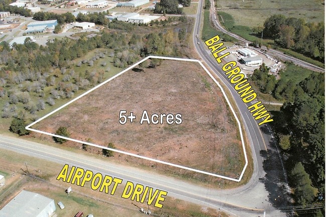
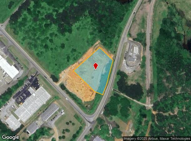
Property Record
Ball Ground Hwy, Ball Ground, GA 30107


NEARBY LISTINGS FOR SALE OR LEASE
Property Detail
Ball Ground Hwy
Atlanta-Sandy Springs-Roswell, GA
LL 318,319,432,433; 3RD D
003N02-00000-001-000-0000
Cherokee
Industrialgeneral
Georgia
X
432
13057C0170E
2.54 AC
2025
Cherokee County
2025
Atlanta
090101
DEMOGRAPHICS near Ball Ground Hwy
1 Mile
3 Mile
5 Mile
2024 Total Population
874
7,496
26,865
2029 Population
1,011
8,650
30,867
Pop Growth 2024-2029
+ 15.68%
+ 15.39%
+ 14.90%
Average Age
41
41
40
2024 Total Households
345
2,680
9,605
HH Growth 2024-2029
+ 15.94%
+ 15.52%
+ 15.04%
Median Household Inc
$59,999
$83,037
$85,244
Avg Household Size
2.60
2.80
2.80
2024 Avg HH Vehicles
2.00
2.00
2.00
Median Home Value
$216,197
$362,737
$377,018
Median Year Built
2004
2004
2001
Nearby Places
Map Layers
Map Styles
 Street
 Aerial
- Restaurants
- Banks
- Shops
- Fitness
- Groceries
SALE & LEASE HISTORY
LISTING DATE
SALE/LEASE

Sep 24, 2016
For Sale
Apr 24, 2017
For Sale
Nearby Properties
Address
Land Use
TOTAL SIZE
Lot Size
Zoning
Address
Land Use
TOTAL SIZE
Lot Size
Zoning
2,752 SF
959.77 AC
AG
Address
Land Use
TOTAL SIZE
Lot Size
Zoning
548,520 SF
70.10 AC
LI
Address
Land Use
TOTAL SIZE
Lot Size
Zoning
687,913 SF
24.31 AC
LI
Address
Land Use
TOTAL SIZE
Lot Size
Zoning
296,607 SF
46.53 AC
LI
Address
Land Use
TOTAL SIZE
Lot Size
Zoning
107,556 SF
13.77 AC
TND
Address
Land Use
TOTAL SIZE
Lot Size
Zoning
84,304 SF
18.65 AC
HI
Address
Land Use
TOTAL SIZE
Lot Size
Zoning
9,142 SF
89.03 AC
LI
Address
Land Use
TOTAL SIZE
Lot Size
Zoning
30,816 SF
63.71 AC
LI
Address
Land Use
TOTAL SIZE
Lot Size
Zoning
58.19 AC
PD-MIXED U
Address
Land Use
TOTAL SIZE
Lot Size
Zoning
62,108 SF
25 AC
OI
Address
Land Use
TOTAL SIZE
Lot Size
Zoning
108,892 SF
16.53 AC
LI
Address
Land Use
TOTAL SIZE
Lot Size
Zoning
82,621 SF
9.63 AC
PD-MU
Address
Land Use
TOTAL SIZE
Lot Size
Zoning
83.99 AC
LI
Address
Land Use
TOTAL SIZE
Lot Size
Zoning
123.28 AC
LI
Address
Land Use
TOTAL SIZE
Lot Size
Zoning
35,530 SF
15.18 AC
TND
Address
Land Use
TOTAL SIZE
Lot Size
Zoning
73,584 SF
10.93 AC
LI
Address
Land Use
TOTAL SIZE
Lot Size
Zoning
1 SF
54.80 AC
AG
Address
Land Use
TOTAL SIZE
Lot Size
Zoning
76,696 SF
5.75 AC
LI
Address
Land Use
TOTAL SIZE
Lot Size
Zoning
21,896 SF
1.63 AC
LI
Address
Land Use
TOTAL SIZE
Lot Size
Zoning
15,748 SF
35.85 AC
HI
Address
Land Use
TOTAL SIZE
Lot Size
Zoning
56,298 SF
5.48 AC
PD-MU
Address
Land Use
TOTAL SIZE
Lot Size
Zoning
57,587 SF
5.89 AC
PD-MU
Address
Land Use
TOTAL SIZE
Lot Size
Zoning
24,800 SF
100.45 AC
HI
Address
Land Use
TOTAL SIZE
Lot Size
Zoning
13,754 SF
2.31 AC
TND
Address
Land Use
TOTAL SIZE
Lot Size
Zoning
49,300 SF
4.18 AC
PD-MU
Address
Land Use
TOTAL SIZE
Lot Size
Zoning
19.45 AC
LI
Address
Land Use
TOTAL SIZE
Lot Size
Zoning
51.33 AC
LI
Address
Land Use
TOTAL SIZE
Lot Size
Zoning
48,750 SF
4.33 AC
PD-MU
Address
Land Use
TOTAL SIZE
Lot Size
Zoning
106,396 SF
12.42 AC
LI
Address
Land Use
TOTAL SIZE
Lot Size
Zoning
85,876 SF
3.96 AC
LI
The World's #1 Commercial Real Estate Marketplace
Connect with us
© 2025 CoStar Group
The information above has been obtained from sources believed reliable. While we do not doubt its accuracy we have not verified it and make no guarantee, warranty or representation about it. It is your responsibility to independently confirm its accuracy and completeness. Any projections, opinions, assumptions, or estimates used are for example only and do not represent the current or future performance of the property. The value of this transaction to you depends on tax and other factors which should be evaluated by your tax, financial, and legal advisors. You and your advisors should conduct a careful, independent investigation of the property to determine to your satisfaction the suitability of the property for your needs.