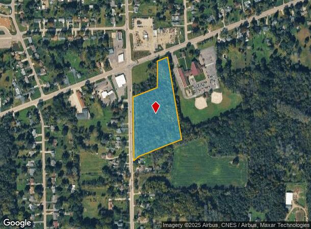
Property Record
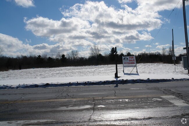
N Belsay Rd, Flint, MI 48506

NEARBY LISTINGS FOR SALE OR LEASE
Property Detail
N Belsay Rd
11-36-300-054
A PARCEL OF LAND BEG E 33 FT & N 81.58 FT & N 70 DEG 12 MIN 23 SEC E 300 FT FROM W 1/4 COR OF SEC TH N 70 DEG 12 MIN 23 SEC E
Residentialacreage
Genesee
X
Michigan
26049C0211D
8.79 AC
2024
Flint
2025
Detroit
012006
Flint, MI
DEMOGRAPHICS near N Belsay Rd
1 Mile
3 Mile
5 Mile
2024 Total Population
3,048
27,169
81,730
2029 Population
2,950
26,552
80,939
Pop Growth 2024-2029
(3.22%)
(2.27%)
(0.97%)
Average Age
43
41
40
2024 Total Households
1,224
11,234
34,480
HH Growth 2024-2029
(3.27%)
(2.35%)
(1.08%)
Median Household Inc
$62,979
$56,523
$47,857
Avg Household Size
2.40
2.30
2.30
2024 Avg HH Vehicles
2.00
2.00
2.00
Median Home Value
$143,565
$141,413
$131,669
Median Year Built
1960
1964
1966
Nearby Places
Map Layers
Map Styles
 Street
 Aerial
- Restaurants
- Banks
- Shops
- Fitness
- Groceries
PUBLIC TRANSPORTATION
COMMUTER RAIL
DRIVE
WALK
Distance
11 min
5.6 mi
AIRPORT
Bishop International
DRIVE
WALK
Distance
Bishop International
29 min
15.1 mi
SALE & LEASE HISTORY
LISTING DATE
SALE/LEASE

Sep 24, 2016
For Sale
Nearby Properties
Address
Land Use
TOTAL SIZE
Lot Size
Zoning
Address
Land Use
TOTAL SIZE
Lot Size
Zoning
MOBILE
Address
Land Use
TOTAL SIZE
Lot Size
Zoning
290,267 SF
79 AC
PC
Address
Land Use
TOTAL SIZE
Lot Size
Zoning
34,652 SF
208.43 AC
SRA
Address
Land Use
TOTAL SIZE
Lot Size
Zoning
302,862 SF
27.14 AC
NOT AVAILA
Address
Land Use
TOTAL SIZE
Lot Size
Zoning
227,669 SF
25.87 AC
C-2
Address
Land Use
TOTAL SIZE
Lot Size
Zoning
371,636 SF
12.50 AC
M-1
Address
Land Use
TOTAL SIZE
Lot Size
Zoning
2,400 SF
81 AC
R-4 MANUF
Address
Land Use
TOTAL SIZE
Lot Size
Zoning
Address
Land Use
TOTAL SIZE
Lot Size
Zoning
111,882 SF
5.36 AC
C-4
Address
Land Use
TOTAL SIZE
Lot Size
Zoning
419,038 SF
57.18 AC
M-2
Address
Land Use
TOTAL SIZE
Lot Size
Zoning
Address
Land Use
TOTAL SIZE
Lot Size
Zoning
107,580 SF
5.18 AC
RETAIL
Address
Land Use
TOTAL SIZE
Lot Size
Zoning
82,240 SF
15.03 AC
C-2
Address
Land Use
TOTAL SIZE
Lot Size
Zoning
14,336 SF
3.29 AC
NOT AVAILA
Address
Land Use
TOTAL SIZE
Lot Size
Zoning
72,720 SF
6.41 AC
C-2
Address
Land Use
TOTAL SIZE
Lot Size
Zoning
57.47 AC
R-4 MANUF
Address
Land Use
TOTAL SIZE
Lot Size
Zoning
726 SF
10.40 AC
R-4 MANUF
Address
Land Use
TOTAL SIZE
Lot Size
Zoning
19,744 SF
3.52 AC
C-2
Address
Land Use
TOTAL SIZE
Lot Size
Zoning
2,560 SF
42 AC
R-4 MANUF
Address
Land Use
TOTAL SIZE
Lot Size
Zoning
10.05 AC
NOT AVAILA
Address
Land Use
TOTAL SIZE
Lot Size
Zoning
58,197 SF
11.90 AC
C-2
Address
Land Use
TOTAL SIZE
Lot Size
Zoning
43,751 SF
3.14 AC
TN-2
Address
Land Use
TOTAL SIZE
Lot Size
Zoning
70,312 SF
30.90 AC
M-1
Address
Land Use
TOTAL SIZE
Lot Size
Zoning
60,000 SF
6.43 AC
NOT AVAILA
Address
Land Use
TOTAL SIZE
Lot Size
Zoning
138,232 SF
16.84 AC
C-4
Address
Land Use
TOTAL SIZE
Lot Size
Zoning
60,925 SF
2.69 AC
M-1
Address
Land Use
TOTAL SIZE
Lot Size
Zoning
74,480 SF
3.73 AC
M-1
Address
Land Use
TOTAL SIZE
Lot Size
Zoning
45,248 SF
10.19 AC
M-1
Address
Land Use
TOTAL SIZE
Lot Size
Zoning
4,554 SF
80.40 AC
RMH
Address
Land Use
TOTAL SIZE
Lot Size
Zoning
44,973 SF
20.21 AC
NOT AVAILA
The World's #1 Commercial Real Estate Marketplace
Connect with us
© 2026 CoStar Group
The information above has been obtained from sources believed reliable. While we do not doubt its accuracy we have not verified it and make no guarantee, warranty or representation about it. It is your responsibility to independently confirm its accuracy and completeness. Any projections, opinions, assumptions, or estimates used are for example only and do not represent the current or future performance of the property. The value of this transaction to you depends on tax and other factors which should be evaluated by your tax, financial, and legal advisors. You and your advisors should conduct a careful, independent investigation of the property to determine to your satisfaction the suitability of the property for your needs.