Property Record
Berens Dr, New Lenox, IL 60451

Save to a Folder
{{folder.Name}}
{{folder.ListingIds.length}} Properties
{{folder.ListingIds.length}} Property
Create a New Folder
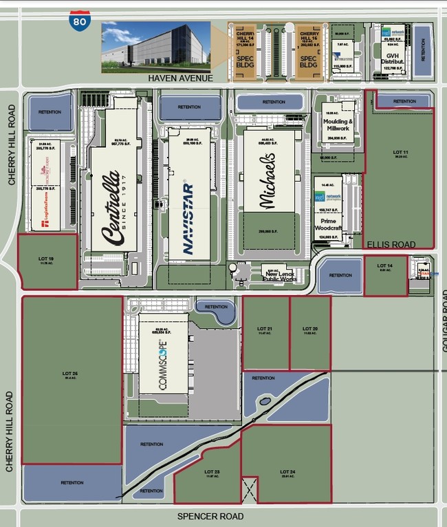
Property Detail
Berens Dr
Chicago-Naperville-Elgin, IL-IN
LOT 2 IN CHERRY HILL RAIL PARK PHASE 1, BEING A SUB OF PRT OF THE E1/2 OF SEC 30, T35N-R11E.
15-08-30-201-003
WILL
Industrialacreage
Illinois
B and X Area of moderate flood hazard, usually the area between the limits of the 100-year and 500-year floods.
2
2025
14.73 AC
2024
Joliet Area
8811091008
Chicago
NEARBY LISTINGS FOR SALE OR LEASE
DEMOGRAPHICS near Berens Dr
1 mile
3 mile
5 mile
2025 Total Population
1,382
27,660
92,614
2030 Population
1,415
28,132
94,565
Pop Growth 2025-2030
+ 2.39%
+ 1.71%
+ 2.11%
Average Age
39
40
38
2025 Total Households
502
9,678
30,951
HH Growth 2025-2030
+ 2.19%
+ 1.68%
+ 2.14%
Median Household Inc
$128,804
$104,825
$92,441
Avg Household Size
2.70
2.80
2.90
2025 Avg HH Vehicles
2.00
2.00
2.00
Median Home Value
$354,117
$351,396
$328,685
Median Year Built
1981
1982
1979
Nearby Places
Map Layers
Map Styles
 Street
 Aerial
Layers
 Traffic
 Biking
Places
Listings with unknown addresses are not visible on the map
- Restaurants
- Banks
- Shops
- Fitness
- Groceries
PUBLIC TRANSPORTATION
COMMUTER RAIL
New Lenox Laraway Road (SouthWest Service - Northeast Illinois Regional Commuter Railroad (Metra))
Drive
Walk
Distance
New Lenox Laraway Road (SouthWest Service - Northeast Illinois Regional Commuter Railroad (Metra))
7 min
3.3 mi
New Lenox Station (Rock Island District Line - Northeast Illinois Regional Commuter Railroad (Metra))
Drive
Walk
Distance
New Lenox Station (Rock Island District Line - Northeast Illinois Regional Commuter Railroad (Metra))
9 min
3.8 mi
AIRPORT
Chicago Midway International
Drive
Walk
Distance
Chicago Midway International
46 min
34.1 mi
Freight Ports
Port Milwaukee
Drive
Walk
Distance
Port Milwaukee
144 min
117.3 mi
SALE & LEASE HISTORY
LISTING DATE
SALE/LEASE

Apr 11, 2017
For Lease
Nearby Properties
Address
Land Use
TOTAL SIZE
Lot Size
Zoning
Address
Land Use
TOTAL SIZE
Lot Size
Zoning
27.63 AC
Address
Land Use
TOTAL SIZE
Lot Size
Zoning
67.82 AC
Address
Land Use
TOTAL SIZE
Lot Size
Zoning
53.05 AC
Address
Land Use
TOTAL SIZE
Lot Size
Zoning
59.92 AC
Address
Land Use
TOTAL SIZE
Lot Size
Zoning
128.88 AC
Address
Land Use
TOTAL SIZE
Lot Size
Zoning
45.09 AC
Address
Land Use
TOTAL SIZE
Lot Size
Zoning
34.48 AC
Address
Land Use
TOTAL SIZE
Lot Size
Zoning
52.25 AC
Address
Land Use
TOTAL SIZE
Lot Size
Zoning
26.04 AC
Address
Land Use
TOTAL SIZE
Lot Size
Zoning
17.49 AC
Address
Land Use
TOTAL SIZE
Lot Size
Zoning
30.99 AC
Address
Land Use
TOTAL SIZE
Lot Size
Zoning
22.77 AC
Address
Land Use
TOTAL SIZE
Lot Size
Zoning
Address
Land Use
TOTAL SIZE
Lot Size
Zoning
20.66 AC
Address
Land Use
TOTAL SIZE
Lot Size
Zoning
38.40 AC
Address
Land Use
TOTAL SIZE
Lot Size
Zoning
12.03 AC
Address
Land Use
TOTAL SIZE
Lot Size
Zoning
5.67 AC
Address
Land Use
TOTAL SIZE
Lot Size
Zoning
13.14 AC
Address
Land Use
TOTAL SIZE
Lot Size
Zoning
10.28 AC
Address
Land Use
TOTAL SIZE
Lot Size
Zoning
16.31 AC
Address
Land Use
TOTAL SIZE
Lot Size
Zoning
19.41 AC
Address
Land Use
TOTAL SIZE
Lot Size
Zoning
11.57 AC
Address
Land Use
TOTAL SIZE
Lot Size
Zoning
8.79 AC
Address
Land Use
TOTAL SIZE
Lot Size
Zoning
Address
Land Use
TOTAL SIZE
Lot Size
Zoning
1.71 AC
Address
Land Use
TOTAL SIZE
Lot Size
Zoning
4.65 AC
Address
Land Use
TOTAL SIZE
Lot Size
Zoning
4.32 AC
Address
Land Use
TOTAL SIZE
Lot Size
Zoning
7.69 AC
Address
Land Use
TOTAL SIZE
Lot Size
Zoning
6.40 AC
Address
Land Use
TOTAL SIZE
Lot Size
Zoning
0.96 AC
The World's #1 Commercial Real Estate Marketplace
Connect with us
© 2026 CoStar Group
The information above has been obtained from sources believed reliable. While we do not doubt its accuracy we have not verified it and make no guarantee, warranty or representation about it. It is your responsibility to independently confirm its accuracy and completeness. Any projections, opinions, assumptions, or estimates used are for example only and do not represent the current or future performance of the property. The value of this transaction to you depends on tax and other factors which should be evaluated by your tax, financial, and legal advisors. You and your advisors should conduct a careful, independent investigation of the property to determine to your satisfaction the suitability of the property for your needs.