Property Record
Caliente Rd, Hesperia, CA 92345
Property Detail
Caliente Rd
Riverside-San Bernardino-Ontario, CA
PARCEL MAP 20159 PTN PAR 2 LYING WITHIN TRA 20069
3039-341-13
SAN BERNARDINO
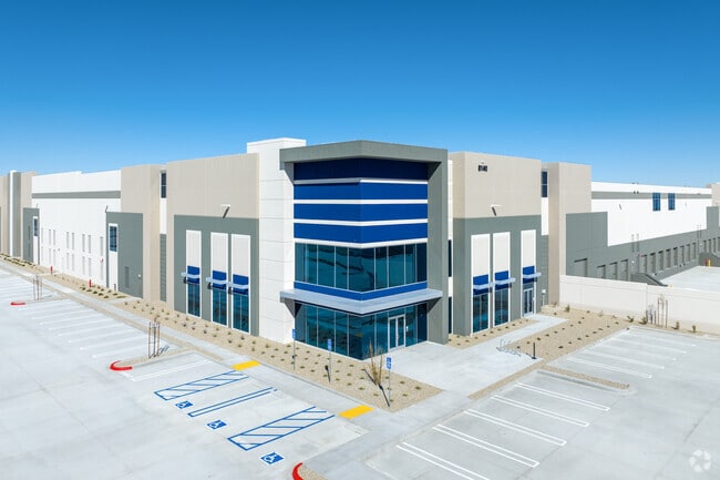
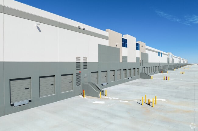
Warehouse
California
B and X Area of moderate flood hazard, usually the area between the limits of the 100-year and 500-year floods.
10.31 AC
2025
Mojave River Valley
2025
Inland Empire (California)
010019
NEARBY LISTINGS FOR SALE OR LEASE
DEMOGRAPHICS near Caliente Rd
1 mile
3 mile
5 mile
2025 Total Population
707
19,344
54,827
2030 Population
715
19,863
56,477
Pop Growth 2025-2030
+ 1.13%
+ 2.68%
+ 3.01%
Average Age
36
37
37
2025 Total Households
185
5,375
15,578
HH Growth 2025-2030
+ 1.08%
+ 2.59%
+ 2.98%
Median Household Inc
$97,499
$99,745
$93,900
Avg Household Size
3.90
3.50
3.40
2025 Avg HH Vehicles
2.00
3.00
3.00
Median Home Value
$651,960
$581,057
$458,632
Median Year Built
2005
2004
2001
Nearby Places
Map Layers
Map Styles
 Street
 Aerial
Layers
 Traffic
 Biking
Places
Listings with unknown addresses are not visible on the map
- Restaurants
- Banks
- Shops
- Fitness
- Groceries
PUBLIC TRANSPORTATION
AIRPORT
Ontario International
Drive
Walk
Distance
Ontario International
43 min
35.7 mi
Freight Ports
Port of Long Beach
Drive
Walk
Distance
Port of Long Beach
105 min
87.8 mi
SALE & LEASE HISTORY
LISTING DATE
SALE/LEASE

Feb 16, 2021
For Lease
Feb 16, 2021
For Sale
Nearby Properties
Address
Land Use
TOTAL SIZE
Lot Size
Zoning
Address
Land Use
TOTAL SIZE
Lot Size
Zoning
1,226,588 SF
54.88 AC
Address
Land Use
TOTAL SIZE
Lot Size
Zoning
1,055,350 SF
59.71 AC
Address
Land Use
TOTAL SIZE
Lot Size
Zoning
1,003,485 SF
54.80 AC
Address
Land Use
TOTAL SIZE
Lot Size
Zoning
315,603 SF
48.21 AC
Address
Land Use
TOTAL SIZE
Lot Size
Zoning
62.93 AC
Address
Land Use
TOTAL SIZE
Lot Size
Zoning
54,994 SF
9.12 AC
Address
Land Use
TOTAL SIZE
Lot Size
Zoning
38.91 AC
Address
Land Use
TOTAL SIZE
Lot Size
Zoning
37.37 AC
Address
Land Use
TOTAL SIZE
Lot Size
Zoning
38.45 AC
Address
Land Use
TOTAL SIZE
Lot Size
Zoning
194,712 SF
20.24 AC
Address
Land Use
TOTAL SIZE
Lot Size
Zoning
177,833 SF
14.29 AC
Address
Land Use
TOTAL SIZE
Lot Size
Zoning
61.29 AC
Address
Land Use
TOTAL SIZE
Lot Size
Zoning
52,612 SF
2 AC
Address
Land Use
TOTAL SIZE
Lot Size
Zoning
83,102 SF
2.94 AC
Address
Land Use
TOTAL SIZE
Lot Size
Zoning
150,000 SF
12.53 AC
Address
Land Use
TOTAL SIZE
Lot Size
Zoning
127,502 SF
9.32 AC
Address
Land Use
TOTAL SIZE
Lot Size
Zoning
28.68 AC
Address
Land Use
TOTAL SIZE
Lot Size
Zoning
14,228 SF
1.53 AC
Address
Land Use
TOTAL SIZE
Lot Size
Zoning
44,532 SF
1.93 AC
Address
Land Use
TOTAL SIZE
Lot Size
Zoning
51,021 SF
4.30 AC
Address
Land Use
TOTAL SIZE
Lot Size
Zoning
10,923 SF
17.01 AC
Address
Land Use
TOTAL SIZE
Lot Size
Zoning
18,800 SF
3.27 AC
Address
Land Use
TOTAL SIZE
Lot Size
Zoning
17.57 AC
Address
Land Use
TOTAL SIZE
Lot Size
Zoning
58.17 AC
Address
Land Use
TOTAL SIZE
Lot Size
Zoning
30.60 AC
Address
Land Use
TOTAL SIZE
Lot Size
Zoning
30,515 SF
2.59 AC
Address
Land Use
TOTAL SIZE
Lot Size
Zoning
20,678 SF
2.48 AC
Address
Land Use
TOTAL SIZE
Lot Size
Zoning
34.57 AC
Address
Land Use
TOTAL SIZE
Lot Size
Zoning
22,500 SF
6.32 AC
The World's #1 Commercial Real Estate Marketplace
Connect with us
© 2026 CoStar Group
The information above has been obtained from sources believed reliable. While we do not doubt its accuracy we have not verified it and make no guarantee, warranty or representation about it. It is your responsibility to independently confirm its accuracy and completeness. Any projections, opinions, assumptions, or estimates used are for example only and do not represent the current or future performance of the property. The value of this transaction to you depends on tax and other factors which should be evaluated by your tax, financial, and legal advisors. You and your advisors should conduct a careful, independent investigation of the property to determine to your satisfaction the suitability of the property for your needs.