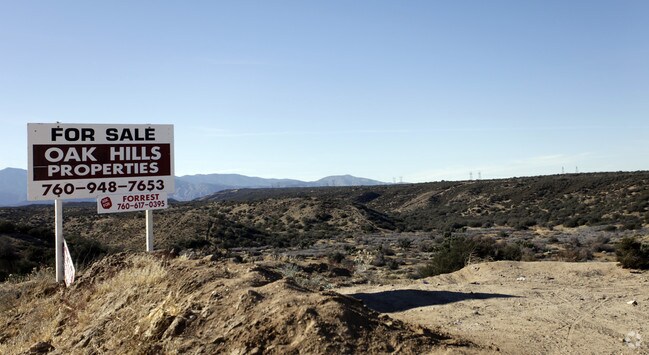
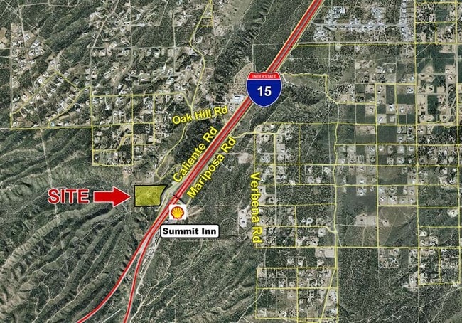
Property Record
Caliente Rd, Oak Hills, CA 92344


Save to a Folder
{{folder.Name}}
{{folder.ListingIds.length}} Properties
{{folder.ListingIds.length}} Property
Create a New Folder
Property Detail
Caliente Rd
Riverside-San Bernardino-Ontario, CA
S 1/2 SE 1/4 NE 1/4 SEC 7 TP 3N R 5W EX STATE HGWY (OD PER 5/18/81 #81-108251 EX PTN VAC ADJ ON N PER 9/29/86 #86-283467)
0357-063-45
SAN BERNARDINO
Vacantlandnec
California
B and X Area of moderate flood hazard, usually the area between the limits of the 100-year and 500-year floods.
14.46 AC
2025
Mojave River Valley
2026
Inland Empire (California)
010042
NEARBY LISTINGS FOR SALE OR LEASE
DEMOGRAPHICS near Caliente Rd
1 mile
3 mile
5 mile
2025 Total Population
656
4,318
15,502
2030 Population
655
4,375
15,869
Pop Growth 2025-2030
(0.15%)
+ 1.32%
+ 2.37%
Average Age
41
41
38
2025 Total Households
213
1,358
4,438
HH Growth 2025-2030
0.00%
+ 1.18%
+ 2.23%
Median Household Inc
$110,714
$124,783
$98,610
Avg Household Size
3.00
3.10
3.40
2025 Avg HH Vehicles
3.00
3.00
3.00
Median Home Value
$681,159
$690,812
$598,006
Median Year Built
1997
2002
2003
Nearby Places
Map Layers
Map Styles
 Street
 Aerial
Layers
 Traffic
 Biking
Places
Listings with unknown addresses are not visible on the map
- Restaurants
- Banks
- Shops
- Fitness
- Groceries
PUBLIC TRANSPORTATION
AIRPORT
Ontario International
Drive
Walk
Distance
Ontario International
39 min
31.7 mi
Freight Ports
Port of Long Beach
Drive
Walk
Distance
Port of Long Beach
101 min
83.8 mi
SALE & LEASE HISTORY
LISTING DATE
SALE/LEASE

Jan 12, 2017
For Sale
Nearby Properties
Address
Land Use
TOTAL SIZE
Lot Size
Zoning
Address
Land Use
TOTAL SIZE
Lot Size
Zoning
1,226,588 SF
54.88 AC
Address
Land Use
TOTAL SIZE
Lot Size
Zoning
1,003,485 SF
54.80 AC
Address
Land Use
TOTAL SIZE
Lot Size
Zoning
6,473 SF
1.34 AC
Address
Land Use
TOTAL SIZE
Lot Size
Zoning
4,798 SF
1.24 AC
Address
Land Use
TOTAL SIZE
Lot Size
Zoning
54.74 AC
Address
Land Use
TOTAL SIZE
Lot Size
Zoning
45.98 AC
Address
Land Use
TOTAL SIZE
Lot Size
Zoning
4,280 SF
1.07 AC
Address
Land Use
TOTAL SIZE
Lot Size
Zoning
1,888 SF
0.81 AC
Address
Land Use
TOTAL SIZE
Lot Size
Zoning
40.50 AC
Address
Land Use
TOTAL SIZE
Lot Size
Zoning
5.77 AC
Address
Land Use
TOTAL SIZE
Lot Size
Zoning
123.35 AC
OHCG
Address
Land Use
TOTAL SIZE
Lot Size
Zoning
3,307 SF
0.88 AC
Address
Land Use
TOTAL SIZE
Lot Size
Zoning
28.77 AC
Address
Land Use
TOTAL SIZE
Lot Size
Zoning
7,224 SF
0.50 AC
OHCG
Address
Land Use
TOTAL SIZE
Lot Size
Zoning
126.87 AC
OHRL
Address
Land Use
TOTAL SIZE
Lot Size
Zoning
125.95 AC
PHRL
Address
Land Use
TOTAL SIZE
Lot Size
Zoning
3,056 SF
5.78 AC
OHCG
Address
Land Use
TOTAL SIZE
Lot Size
Zoning
11,000 SF
7.54 AC
OHCG
Address
Land Use
TOTAL SIZE
Lot Size
Zoning
31 SF
4.79 AC
OHFW
Address
Land Use
TOTAL SIZE
Lot Size
Zoning
0.75 AC
Address
Land Use
TOTAL SIZE
Lot Size
Zoning
1.36 AC
Address
Land Use
TOTAL SIZE
Lot Size
Zoning
1,596 SF
0.73 AC
Address
Land Use
TOTAL SIZE
Lot Size
Zoning
38.20 AC
OHRL
Address
Land Use
TOTAL SIZE
Lot Size
Zoning
4,212 SF
0.92 AC
Address
Land Use
TOTAL SIZE
Lot Size
Zoning
11,169 SF
28.13 AC
OHRL
Address
Land Use
TOTAL SIZE
Lot Size
Zoning
10 AC
Address
Land Use
TOTAL SIZE
Lot Size
Zoning
1,440 SF
5.06 AC
Address
Land Use
TOTAL SIZE
Lot Size
Zoning
156.57 AC
OHRC
The World's #1 Commercial Real Estate Marketplace
Connect with us
© 2026 CoStar Group
The information above has been obtained from sources believed reliable. While we do not doubt its accuracy we have not verified it and make no guarantee, warranty or representation about it. It is your responsibility to independently confirm its accuracy and completeness. Any projections, opinions, assumptions, or estimates used are for example only and do not represent the current or future performance of the property. The value of this transaction to you depends on tax and other factors which should be evaluated by your tax, financial, and legal advisors. You and your advisors should conduct a careful, independent investigation of the property to determine to your satisfaction the suitability of the property for your needs.