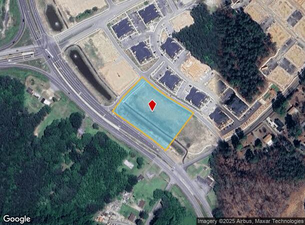
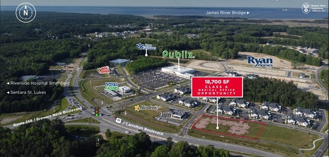
Property Record
Carrollton Blvd, Carrollton, VA 23314

NEARBY LISTINGS FOR SALE OR LEASE
Property Detail
Carrollton Blvd
Hampton Roads
Crossings
Virginia Beach-Chesapeake-Norfolk, VA-NC
PARCEL F JAMES RIVER CROSSINGS INC PROPERTY PLAT I#216527
34-01-070D3
Isle of Wight
Commercialacreage
Virginia
2025
2.61 AC
2025
Isle Of Wight
280108
DEMOGRAPHICS near Carrollton Blvd
1 Mile
3 Mile
5 Mile
2024 Total Population
3,301
11,759
23,073
2029 Population
3,914
13,974
27,276
Pop Growth 2024-2029
+ 18.57%
+ 18.84%
+ 18.22%
Average Age
42
42
43
2024 Total Households
1,332
4,574
8,929
HH Growth 2024-2029
+ 18.32%
+ 18.80%
+ 18.31%
Median Household Inc
$106,282
$106,101
$112,155
Avg Household Size
2.50
2.50
2.60
2024 Avg HH Vehicles
2.00
2.00
2.00
Median Home Value
$350,476
$389,603
$384,838
Median Year Built
1999
1999
1995
Nearby Places
Map Layers
Map Styles
 Street
 Aerial
- Restaurants
- Banks
- Shops
- Fitness
- Groceries
PUBLIC TRANSPORTATION
COMMUTER RAIL
Newport News (Northeast Regional - Amtrak)
DRIVE
WALK
Distance
Newport News (Northeast Regional - Amtrak)
12 min
8.0 mi
AIRPORT
Newport News/Williamsburg International
DRIVE
WALK
Distance
Newport News/Williamsburg International
30 min
17.1 mi
Norfolk International
DRIVE
WALK
Distance
Norfolk International
42 min
24.7 mi
Freight Ports
Virginia Port Authority - Newport News
DRIVE
WALK
Distance
Virginia Port Authority - Newport News
18 min
10.5 mi
Nearby Properties
Address
Land Use
TOTAL SIZE
Lot Size
Zoning
Address
Land Use
TOTAL SIZE
Lot Size
Zoning
27,718 SF
18.75 AC
Address
Land Use
TOTAL SIZE
Lot Size
Zoning
9,600 SF
17.35 AC
PDR
Address
Land Use
TOTAL SIZE
Lot Size
Zoning
3,998 SF
15.79 AC
01
Address
Land Use
TOTAL SIZE
Lot Size
Zoning
13,368 SF
19.96 AC
PDR
Address
Land Use
TOTAL SIZE
Lot Size
Zoning
51,086 SF
43.12 AC
01
Address
Land Use
TOTAL SIZE
Lot Size
Zoning
99,606 SF
34.89 AC
RAC
Address
Land Use
TOTAL SIZE
Lot Size
Zoning
77,001 SF
13.97 AC
01
Address
Land Use
TOTAL SIZE
Lot Size
Zoning
26,471 SF
29.55 AC
01
Address
Land Use
TOTAL SIZE
Lot Size
Zoning
57,513 SF
11.37 AC
Address
Land Use
TOTAL SIZE
Lot Size
Zoning
22,750 SF
19.51 AC
RAC
Address
Land Use
TOTAL SIZE
Lot Size
Zoning
99.89 AC
01
Address
Land Use
TOTAL SIZE
Lot Size
Zoning
1,018 SF
8.03 AC
GC
Address
Land Use
TOTAL SIZE
Lot Size
Zoning
4,900 SF
1.17 AC
Address
Land Use
TOTAL SIZE
Lot Size
Zoning
3,236 SF
55.59 AC
01
Address
Land Use
TOTAL SIZE
Lot Size
Zoning
25,200 SF
4.71 AC
01
Address
Land Use
TOTAL SIZE
Lot Size
Zoning
1,236.54 AC
RAC
Address
Land Use
TOTAL SIZE
Lot Size
Zoning
11,187 SF
2.74 AC
01
Address
Land Use
TOTAL SIZE
Lot Size
Zoning
2,541 SF
10.93 AC
07
Address
Land Use
TOTAL SIZE
Lot Size
Zoning
4,744 SF
5.11 AC
Address
Land Use
TOTAL SIZE
Lot Size
Zoning
110 AC
RAC
Address
Land Use
TOTAL SIZE
Lot Size
Zoning
14,788 SF
4.14 AC
RAC
Address
Land Use
TOTAL SIZE
Lot Size
Zoning
16,248 SF
7.03 AC
RAC
Address
Land Use
TOTAL SIZE
Lot Size
Zoning
26,922 SF
4.33 AC
01
Address
Land Use
TOTAL SIZE
Lot Size
Zoning
22.74 AC
01
Address
Land Use
TOTAL SIZE
Lot Size
Zoning
3,050 SF
2.48 AC
01
Address
Land Use
TOTAL SIZE
Lot Size
Zoning
3,340 SF
2.23 AC
01
Address
Land Use
TOTAL SIZE
Lot Size
Zoning
2,728 SF
51.27 AC
PDMX
Address
Land Use
TOTAL SIZE
Lot Size
Zoning
31,485 SF
2.89 AC
01
Address
Land Use
TOTAL SIZE
Lot Size
Zoning
4,628 SF
1.45 AC
Address
Land Use
TOTAL SIZE
Lot Size
Zoning
12,708 SF
1 AC
01
The World's #1 Commercial Real Estate Marketplace
Connect with us
© 2026 CoStar Group
The information above has been obtained from sources believed reliable. While we do not doubt its accuracy we have not verified it and make no guarantee, warranty or representation about it. It is your responsibility to independently confirm its accuracy and completeness. Any projections, opinions, assumptions, or estimates used are for example only and do not represent the current or future performance of the property. The value of this transaction to you depends on tax and other factors which should be evaluated by your tax, financial, and legal advisors. You and your advisors should conduct a careful, independent investigation of the property to determine to your satisfaction the suitability of the property for your needs.