Property Record
Clay Whaley Rd, Saint Cloud, FL 34772
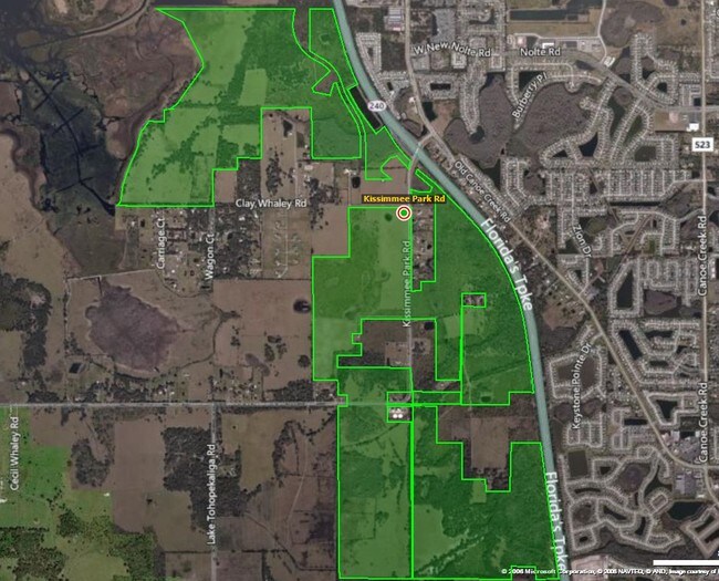
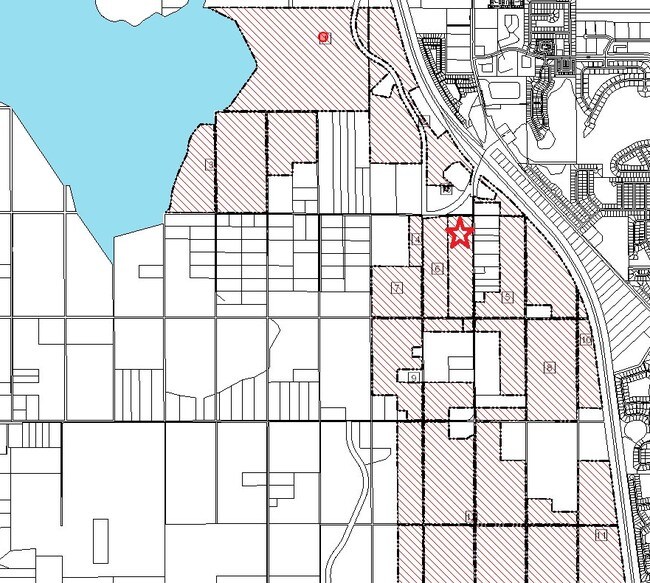
Property Detail
Clay Whaley Rd
Orlando-Kissimmee-Sanford, FL
S L & I C PB B PG 8 LOTS 71-74, 87-90, 104-106, 108, 117-119, 122 & 123 LESS S 250 FT OF W 250 FT OF LOT 122 & LESS S 250 FT OF E 250 FT OF LOT 87 & LESS THAT PORTION LYING WITHIN ABOVE SAID LEGAL:COM AT NW COR OF 21-26-30, S00-15-17E 1320.21 FT, S89
17-26-30-0000-0010-0000
OSCEOLA
Pasture
Florida
OAC
71
AE The base floodplain where base flood elevations are provided. AE Zones are now used on new format FIRMs instead of A1-A30 Zones.
107.80 AC
2024
Osceola Outlying
2025
Orlando
043304
NEARBY LISTINGS FOR SALE OR LEASE
DEMOGRAPHICS near Clay Whaley Rd
1 mile
3 mile
5 mile
2025 Total Population
5,704
47,249
92,793
2030 Population
6,742
55,268
109,177
Pop Growth 2025-2030
+ 18.20%
+ 16.97%
+ 17.66%
Average Age
40
38
39
2025 Total Households
1,947
15,800
31,571
HH Growth 2025-2030
+ 19.05%
+ 17.59%
+ 18.24%
Median Household Inc
$93,457
$85,814
$85,658
Avg Household Size
2.90
3.00
2.90
2025 Avg HH Vehicles
2.00
2.00
2.00
Median Home Value
$536,145
$385,252
$388,581
Median Year Built
2006
2005
2005
Nearby Places
Map Layers
Map Styles
 Street
 Aerial
Layers
 Traffic
 Biking
Places
Listings with unknown addresses are not visible on the map
- Restaurants
- Banks
- Shops
- Fitness
- Groceries
PUBLIC TRANSPORTATION
COMMUTER RAIL
Kissimmee Amtrak Station (Silver Meteor - Amtrak, Silver Star - Amtrak, SunRail - Amtrak)
Drive
Walk
Distance
Kissimmee Amtrak Station (Silver Meteor - Amtrak, Silver Star - Amtrak, SunRail - Amtrak)
21 min
10.0 mi
AIRPORT
Orlando International
Drive
Walk
Distance
Orlando International
34 min
23.1 mi
Freight Ports
Port Canaveral
Drive
Walk
Distance
Port Canaveral
80 min
64.8 mi
Nearby Properties
Address
Land Use
TOTAL SIZE
Lot Size
Zoning
Address
Land Use
TOTAL SIZE
Lot Size
Zoning
270,959 SF
10.84 AC
SPUD
Address
Land Use
TOTAL SIZE
Lot Size
Zoning
275,507 SF
22.19 AC
RM-2
Address
Land Use
TOTAL SIZE
Lot Size
Zoning
187,302 SF
20.85 AC
Address
Land Use
TOTAL SIZE
Lot Size
Zoning
118,121 SF
237.16 AC
SP
Address
Land Use
TOTAL SIZE
Lot Size
Zoning
208,677 SF
12.64 AC
Address
Land Use
TOTAL SIZE
Lot Size
Zoning
198,144 SF
12.18 AC
SR4
Address
Land Use
TOTAL SIZE
Lot Size
Zoning
227,369 SF
18.57 AC
ORM3
Address
Land Use
TOTAL SIZE
Lot Size
Zoning
82,614 SF
9.89 AC
SHB
Address
Land Use
TOTAL SIZE
Lot Size
Zoning
188,778 SF
15.62 AC
SR4
Address
Land Use
TOTAL SIZE
Lot Size
Zoning
106,078 SF
15.04 AC
SP
Address
Land Use
TOTAL SIZE
Lot Size
Zoning
50,025 SF
4.45 AC
SP
Address
Land Use
TOTAL SIZE
Lot Size
Zoning
79,854 SF
8.89 AC
SHB
Address
Land Use
TOTAL SIZE
Lot Size
Zoning
136,124 SF
14.46 AC
SAC
Address
Land Use
TOTAL SIZE
Lot Size
Zoning
137,208 SF
37.64 AC
OAC
Address
Land Use
TOTAL SIZE
Lot Size
Zoning
122,514 SF
22.15 AC
OAC
Address
Land Use
TOTAL SIZE
Lot Size
Zoning
102,869 SF
1.71 AC
Address
Land Use
TOTAL SIZE
Lot Size
Zoning
187,534 SF
19.79 AC
Address
Land Use
TOTAL SIZE
Lot Size
Zoning
4,940 SF
280.16 AC
AC
Address
Land Use
TOTAL SIZE
Lot Size
Zoning
60,772 SF
6.42 AC
SP
Address
Land Use
TOTAL SIZE
Lot Size
Zoning
84,902 SF
11.12 AC
SPUD
Address
Land Use
TOTAL SIZE
Lot Size
Zoning
66,682 SF
8.42 AC
SHB
Address
Land Use
TOTAL SIZE
Lot Size
Zoning
98,303 SF
3.34 AC
OCG
Address
Land Use
TOTAL SIZE
Lot Size
Zoning
88,725 SF
5.79 AC
SHB
Address
Land Use
TOTAL SIZE
Lot Size
Zoning
46.97 AC
Address
Land Use
TOTAL SIZE
Lot Size
Zoning
252.62 AC
Address
Land Use
TOTAL SIZE
Lot Size
Zoning
78,510 SF
3.95 AC
SI1
Address
Land Use
TOTAL SIZE
Lot Size
Zoning
103,716 SF
16.73 AC
SHB
Address
Land Use
TOTAL SIZE
Lot Size
Zoning
88,369 SF
15.54 AC
Address
Land Use
TOTAL SIZE
Lot Size
Zoning
92,108 SF
11.44 AC
SHB
Address
Land Use
TOTAL SIZE
Lot Size
Zoning
17.38 AC
AC
The World's #1 Commercial Real Estate Marketplace
Connect with us
© 2026 CoStar Group
The information above has been obtained from sources believed reliable. While we do not doubt its accuracy we have not verified it and make no guarantee, warranty or representation about it. It is your responsibility to independently confirm its accuracy and completeness. Any projections, opinions, assumptions, or estimates used are for example only and do not represent the current or future performance of the property. The value of this transaction to you depends on tax and other factors which should be evaluated by your tax, financial, and legal advisors. You and your advisors should conduct a careful, independent investigation of the property to determine to your satisfaction the suitability of the property for your needs.