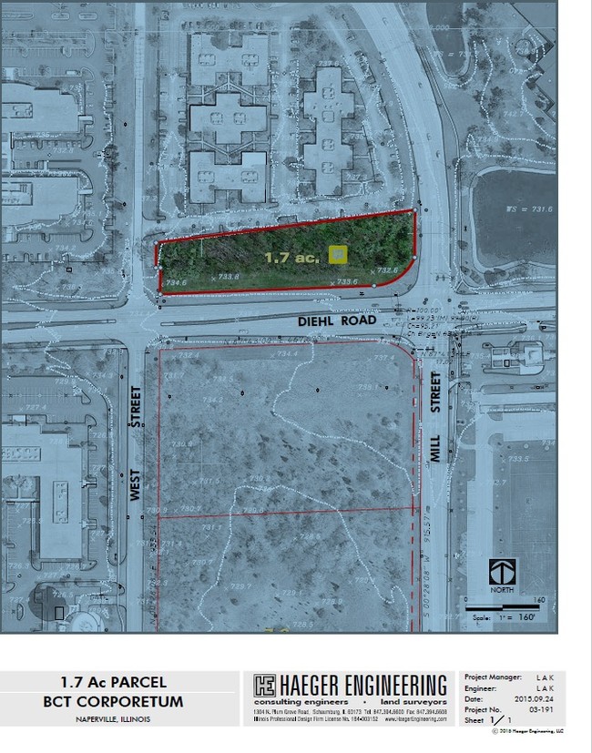
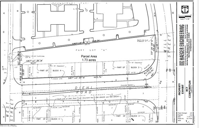
Property Record
Diehl Rd, Naperville, IL 60563
This Property Is For Sale
NEARBY LISTINGS FOR SALE OR LEASE
Property Detail
Diehl Rd
Chicago-Naperville-Elgin, IL-IN
Naper Villa Manor
07-01-401-013
NAPER VILLA MANOR /EX HWY DESC R89-84246/
Sfr
DuPage
X
Illinois
17043C0142J
1
2024
0.21 AC
2024
Western East/West Corr
846405
Chicago
DEMOGRAPHICS near Diehl Rd
1 mile
3 mile
5 mile
2024 Total Population
7,325
68,353
195,672
2029 Population
7,315
67,248
192,376
Pop Growth 2024-2029
(0.14%)
(1.62%)
(1.68%)
Average Age
43
41
40
2024 Total Households
2,896
26,689
76,266
HH Growth 2024-2029
(0.10%)
(1.52%)
(1.70%)
Median Household Inc
$121,720
$107,753
$111,760
Avg Household Size
2.40
2.40
2.50
2024 Avg HH Vehicles
2.00
2.00
2.00
Median Home Value
$462,078
$425,126
$399,871
Median Year Built
1978
1982
1982
Nearby Places
Map Layers
Map Styles
 Street
 Aerial
Transit
 Traffic
 Biking
Places
Listings with unknown addresses are not visible on the map
- Restaurants
- Banks
- Shops
- Fitness
- Groceries
PUBLIC TRANSPORTATION
COMMUTER RAIL
Naperville Station (Burlington Northern-Santa Fe Railway Line - Northeast Illinois Regional Commuter Railroad (Metra))
Drive
Walk
Distance
Naperville Station (Burlington Northern-Santa Fe Railway Line - Northeast Illinois Regional Commuter Railroad (Metra))
5 min
2.1 mi
Route 59 Station (Burlington Northern-Santa Fe Railway Line - Northeast Illinois Regional Commuter Railroad (Metra))
Drive
Walk
Distance
Route 59 Station (Burlington Northern-Santa Fe Railway Line - Northeast Illinois Regional Commuter Railroad (Metra))
9 min
4.5 mi
AIRPORT
Chicago Midway International
Drive
Walk
Distance
Chicago Midway International
40 min
27.1 mi
Chicago O'Hare International
Drive
Walk
Distance
Chicago O'Hare International
40 min
28.0 mi
Freight Ports
Port Milwaukee
Drive
Walk
Distance
Port Milwaukee
121 min
99.7 mi
Nearby Properties
Address
Land Use
TOTAL SIZE
Lot Size
Zoning
Address
Land Use
TOTAL SIZE
Lot Size
Zoning
83.99 AC
Address
Land Use
TOTAL SIZE
Lot Size
Zoning
Address
Land Use
TOTAL SIZE
Lot Size
Zoning
17.59 AC
Address
Land Use
TOTAL SIZE
Lot Size
Zoning
31.66 AC
C
Address
Land Use
TOTAL SIZE
Lot Size
Zoning
Address
Land Use
TOTAL SIZE
Lot Size
Zoning
797,399 SF
52.38 AC
C
Address
Land Use
TOTAL SIZE
Lot Size
Zoning
272,400 SF
20.94 AC
C
Address
Land Use
TOTAL SIZE
Lot Size
Zoning
20.05 AC
C
Address
Land Use
TOTAL SIZE
Lot Size
Zoning
315,328 SF
5.06 AC
Address
Land Use
TOTAL SIZE
Lot Size
Zoning
25 AC
M
Address
Land Use
TOTAL SIZE
Lot Size
Zoning
9.18 AC
C
Address
Land Use
TOTAL SIZE
Lot Size
Zoning
15.33 AC
I
Address
Land Use
TOTAL SIZE
Lot Size
Zoning
5.43 AC
Address
Land Use
TOTAL SIZE
Lot Size
Zoning
8.36 AC
C
Address
Land Use
TOTAL SIZE
Lot Size
Zoning
266,118 SF
21.65 AC
C
Address
Land Use
TOTAL SIZE
Lot Size
Zoning
1,059,897 SF
122.10 AC
C
Address
Land Use
TOTAL SIZE
Lot Size
Zoning
721,600 SF
34.74 AC
I
Address
Land Use
TOTAL SIZE
Lot Size
Zoning
16.15 AC
M
Address
Land Use
TOTAL SIZE
Lot Size
Zoning
166,222 SF
8.81 AC
C
Address
Land Use
TOTAL SIZE
Lot Size
Zoning
15.61 AC
M
Address
Land Use
TOTAL SIZE
Lot Size
Zoning
13.67 AC
M
Address
Land Use
TOTAL SIZE
Lot Size
Zoning
31.08 AC
Address
Land Use
TOTAL SIZE
Lot Size
Zoning
Address
Land Use
TOTAL SIZE
Lot Size
Zoning
239,418 SF
21.27 AC
C
Address
Land Use
TOTAL SIZE
Lot Size
Zoning
6.59 AC
Address
Land Use
TOTAL SIZE
Lot Size
Zoning
16.26 AC
C
Address
Land Use
TOTAL SIZE
Lot Size
Zoning
12.70 AC
Address
Land Use
TOTAL SIZE
Lot Size
Zoning
127,295 SF
1.44 AC
B
Address
Land Use
TOTAL SIZE
Lot Size
Zoning
13.27 AC
M
Address
Land Use
TOTAL SIZE
Lot Size
Zoning
712,133 SF
63.75 AC
The World's #1 Commercial Real Estate Marketplace
Connect with us
© 2026 CoStar Group
The information above has been obtained from sources believed reliable. While we do not doubt its accuracy we have not verified it and make no guarantee, warranty or representation about it. It is your responsibility to independently confirm its accuracy and completeness. Any projections, opinions, assumptions, or estimates used are for example only and do not represent the current or future performance of the property. The value of this transaction to you depends on tax and other factors which should be evaluated by your tax, financial, and legal advisors. You and your advisors should conduct a careful, independent investigation of the property to determine to your satisfaction the suitability of the property for your needs.