Property Record
E Irlo Bronson Memorial Hwy, Saint Cloud, FL 34771
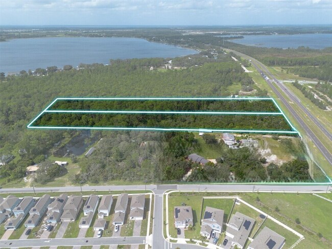

This Property Is For Sale
NEARBY LISTINGS FOR SALE OR LEASE
-
-
No Photo
-
-
-
-
-
View all Saint Cloud listings for sale on LoopNet.com
Property Detail
E Irlo Bronson Memorial Hwy
Orlando-Kissimmee-Sanford, FL
Whip O Will Hill
14-26-31-5475-0001-00D0
WHIP-O-WILL HILL PB 2 PG 149 LOT D LESS COM AT E 1/4 COR OF SEC, W 1519.03 FT, N 31 DEG W 143.96 FT, S 59 DEG W 33.00 FT TO SELY COR TRACT C AND POB, S 59 DEG W 19.51 FT, N 26 DEG W 257.00 FT, S 31 DEG E 256.25 FT TO POB
Vacantlandnec
Osceola
X
Florida
12097C0285G
d
2024
5.05 AC
2025
Osceola Outlying
043700
Orlando
DEMOGRAPHICS near E Irlo Bronson Memorial Hwy
1 Mile
3 Mile
5 Mile
2024 Total Population
1,152
10,497
31,945
2029 Population
1,413
12,874
39,415
Pop Growth 2024-2029
+ 22.66%
+ 22.64%
+ 23.38%
Average Age
41
40
39
2024 Total Households
406
3,594
10,888
HH Growth 2024-2029
+ 22.41%
+ 22.40%
+ 23.30%
Median Household Inc
$69,230
$76,288
$77,426
Avg Household Size
2.80
2.90
2.90
2024 Avg HH Vehicles
3.00
2.00
2.00
Median Home Value
$371,653
$344,763
$342,399
Median Year Built
2005
2009
2010
Nearby Places
Map Layers
Map Styles
 Street
 Aerial
- Restaurants
- Banks
- Shops
- Fitness
- Groceries
PUBLIC TRANSPORTATION
AIRPORT
Orlando International
DRIVE
WALK
Distance
Orlando International
39 min
25.0 mi
Freight Ports
Port Canaveral
DRIVE
WALK
Distance
Port Canaveral
76 min
48.0 mi
Nearby Properties
Address
Land Use
TOTAL SIZE
Lot Size
Zoning
Address
Land Use
TOTAL SIZE
Lot Size
Zoning
121,656 SF
9.49 AC
OPD
Address
Land Use
TOTAL SIZE
Lot Size
Zoning
107,288 SF
10.23 AC
OMXD
Address
Land Use
TOTAL SIZE
Lot Size
Zoning
13.38 AC
Address
Land Use
TOTAL SIZE
Lot Size
Zoning
22.31 AC
OAC
Address
Land Use
TOTAL SIZE
Lot Size
Zoning
619.50 AC
OA1A
Address
Land Use
TOTAL SIZE
Lot Size
Zoning
4.73 AC
Address
Land Use
TOTAL SIZE
Lot Size
Zoning
20,046 SF
1.46 AC
OMXD
Address
Land Use
TOTAL SIZE
Lot Size
Zoning
1,944 SF
16.47 AC
SA
Address
Land Use
TOTAL SIZE
Lot Size
Zoning
108.50 AC
Address
Land Use
TOTAL SIZE
Lot Size
Zoning
41.79 AC
RS-1C
Address
Land Use
TOTAL SIZE
Lot Size
Zoning
3,290 SF
1.60 AC
OPD
Address
Land Use
TOTAL SIZE
Lot Size
Zoning
3.95 AC
Address
Land Use
TOTAL SIZE
Lot Size
Zoning
1,842 SF
62.92 AC
OIN
Address
Land Use
TOTAL SIZE
Lot Size
Zoning
2.44 AC
Address
Land Use
TOTAL SIZE
Lot Size
Zoning
253.20 AC
OAC
Address
Land Use
TOTAL SIZE
Lot Size
Zoning
10,348 SF
326.84 AC
OAC
Address
Land Use
TOTAL SIZE
Lot Size
Zoning
60.69 AC
AC
Address
Land Use
TOTAL SIZE
Lot Size
Zoning
42.04 AC
AC
Address
Land Use
TOTAL SIZE
Lot Size
Zoning
7,004 SF
3.61 AC
RS-1C
Address
Land Use
TOTAL SIZE
Lot Size
Zoning
2.60 AC
Address
Land Use
TOTAL SIZE
Lot Size
Zoning
6,114 SF
3.10 AC
RS-2
Address
Land Use
TOTAL SIZE
Lot Size
Zoning
218.50 AC
OA1A
Address
Land Use
TOTAL SIZE
Lot Size
Zoning
1,400 SF
1.73 AC
OCG
Address
Land Use
TOTAL SIZE
Lot Size
Zoning
24.20 AC
Address
Land Use
TOTAL SIZE
Lot Size
Zoning
32.19 AC
OPUD
Address
Land Use
TOTAL SIZE
Lot Size
Zoning
2.07 AC
Address
Land Use
TOTAL SIZE
Lot Size
Zoning
31.91 AC
Address
Land Use
TOTAL SIZE
Lot Size
Zoning
3,240 SF
8.10 AC
OCG
Address
Land Use
TOTAL SIZE
Lot Size
Zoning
6,534 SF
5.48 AC
ORMH
The World's #1 Commercial Real Estate Marketplace
Connect with us
© 2026 CoStar Group
The information above has been obtained from sources believed reliable. While we do not doubt its accuracy we have not verified it and make no guarantee, warranty or representation about it. It is your responsibility to independently confirm its accuracy and completeness. Any projections, opinions, assumptions, or estimates used are for example only and do not represent the current or future performance of the property. The value of this transaction to you depends on tax and other factors which should be evaluated by your tax, financial, and legal advisors. You and your advisors should conduct a careful, independent investigation of the property to determine to your satisfaction the suitability of the property for your needs.