Property Record
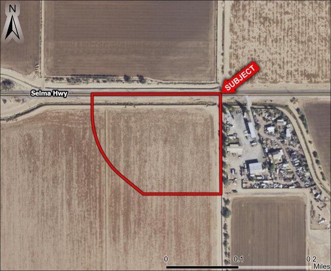
E Selma Hwy, , AZ

This Property Is For Sale
Property Detail
E Selma Hwy
511-20-002H
BEG @ THE N1/4 COR OF SEC 1 7S 6E TH S 608 TH W 473.5 TH N 50D W 164.86 TH NWLY ALONG CRV W/RAD 500 A DIST OF 443.31 TH N 116.27 T H E 783.61 TO POB, 9.86 AC
Farms
PINAL
UNDESIGNAT
Arizona
B and X Area of moderate flood hazard, usually the area between the limits of the 100-year and 500-year floods.
9.86 AC
2024
Pinal County
2025
Phoenix
000000
Phoenix-Mesa-Chandler, AZ
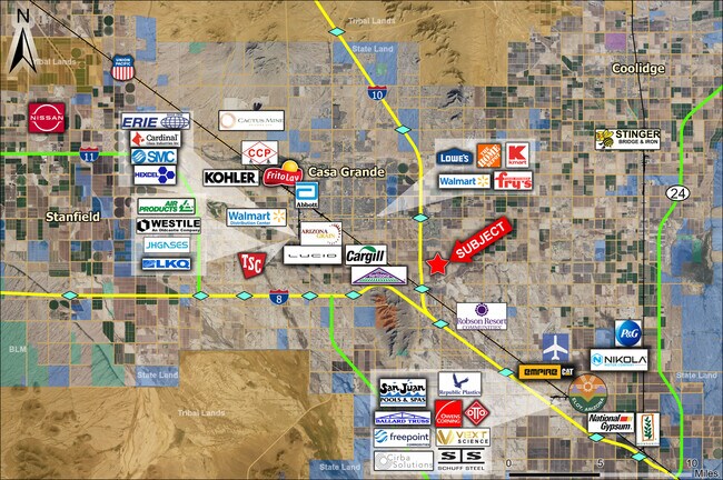
NEARBY LISTINGS FOR SALE OR LEASE
DEMOGRAPHICS near E Selma Hwy
1 mile
3 mile
5 mile
2025 Total Population
1,184
7,647
44,026
2030 Population
1,419
9,116
52,361
Pop Growth 2025-2030
+ 19.85%
+ 19.21%
+ 18.93%
Average Age
50
51
45
2025 Total Households
502
3,339
17,155
HH Growth 2025-2030
+ 19.52%
+ 18.75%
+ 19.05%
Median Household Inc
$88,808
$70,452
$70,202
Avg Household Size
2.40
2.30
2.50
2025 Avg HH Vehicles
2.00
2.00
2.00
Median Home Value
$407,670
$363,740
$341,349
Median Year Built
2010
2005
2004
Nearby Places
Map Layers
Map Styles
 Street
 Aerial
Layers
 Traffic
 Biking
Places
Listings with unknown addresses are not visible on the map
- Restaurants
- Banks
- Shops
- Fitness
- Groceries
Nearby Properties
Address
Land Use
TOTAL SIZE
Lot Size
Zoning
Address
Land Use
TOTAL SIZE
Lot Size
Zoning
48,433 SF
266.50 AC
Address
Land Use
TOTAL SIZE
Lot Size
Zoning
579,373 SF
32.18 AC
UNDESIGNAT
Address
Land Use
TOTAL SIZE
Lot Size
Zoning
272,663 SF
27.20 AC
Address
Land Use
TOTAL SIZE
Lot Size
Zoning
216,795 SF
11.15 AC
Address
Land Use
TOTAL SIZE
Lot Size
Zoning
131,386 SF
1.29 AC
UNDESIGNAT
Address
Land Use
TOTAL SIZE
Lot Size
Zoning
222,134 SF
24.14 AC
Address
Land Use
TOTAL SIZE
Lot Size
Zoning
173,706 SF
8.69 AC
Address
Land Use
TOTAL SIZE
Lot Size
Zoning
63,541 SF
12.10 AC
Address
Land Use
TOTAL SIZE
Lot Size
Zoning
134,042 SF
15.68 AC
Address
Land Use
TOTAL SIZE
Lot Size
Zoning
42,077 SF
3.37 AC
Address
Land Use
TOTAL SIZE
Lot Size
Zoning
125,899 SF
10.47 AC
Address
Land Use
TOTAL SIZE
Lot Size
Zoning
143,860 SF
14.88 AC
Address
Land Use
TOTAL SIZE
Lot Size
Zoning
189,892 SF
39.82 AC
UNDESIGNAT
Address
Land Use
TOTAL SIZE
Lot Size
Zoning
88,755 SF
7.60 AC
Address
Land Use
TOTAL SIZE
Lot Size
Zoning
100,086 SF
8.24 AC
Address
Land Use
TOTAL SIZE
Lot Size
Zoning
74,433 SF
15.44 AC
UNDESIGNAT
Address
Land Use
TOTAL SIZE
Lot Size
Zoning
45,799 SF
7.24 AC
Address
Land Use
TOTAL SIZE
Lot Size
Zoning
41,824 SF
8.74 AC
Address
Land Use
TOTAL SIZE
Lot Size
Zoning
103,413 SF
7.74 AC
Address
Land Use
TOTAL SIZE
Lot Size
Zoning
91,880 SF
13.63 AC
Address
Land Use
TOTAL SIZE
Lot Size
Zoning
39,422 SF
2.04 AC
Address
Land Use
TOTAL SIZE
Lot Size
Zoning
16,100 SF
43.35 AC
UNDESIGNAT
Address
Land Use
TOTAL SIZE
Lot Size
Zoning
40,859 SF
3.77 AC
Address
Land Use
TOTAL SIZE
Lot Size
Zoning
92,980 SF
19.29 AC
CI2
Address
Land Use
TOTAL SIZE
Lot Size
Zoning
78,092 SF
3.95 AC
UNDESIGNAT
Address
Land Use
TOTAL SIZE
Lot Size
Zoning
39,634 SF
1.79 AC
UNDESIGNAT
Address
Land Use
TOTAL SIZE
Lot Size
Zoning
40,685 SF
4.30 AC
Address
Land Use
TOTAL SIZE
Lot Size
Zoning
26,328 SF
22.85 AC
UNDESIGNAT
Address
Land Use
TOTAL SIZE
Lot Size
Zoning
32,596 SF
1.78 AC
UNDESIGNAT
Address
Land Use
TOTAL SIZE
Lot Size
Zoning
33,304 SF
3.59 AC
UNDESIGNAT
The World's #1 Commercial Real Estate Marketplace
Connect with us
© 2026 CoStar Group
The information above has been obtained from sources believed reliable. While we do not doubt its accuracy we have not verified it and make no guarantee, warranty or representation about it. It is your responsibility to independently confirm its accuracy and completeness. Any projections, opinions, assumptions, or estimates used are for example only and do not represent the current or future performance of the property. The value of this transaction to you depends on tax and other factors which should be evaluated by your tax, financial, and legal advisors. You and your advisors should conduct a careful, independent investigation of the property to determine to your satisfaction the suitability of the property for your needs.