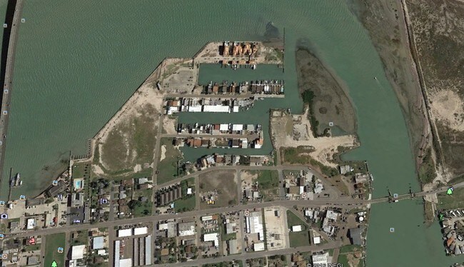
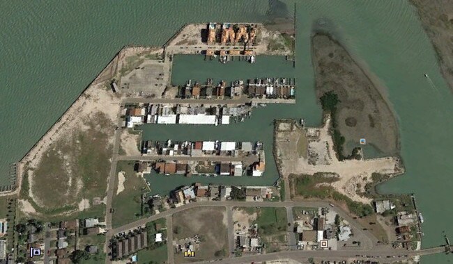
Property Record
E Washinton St, Port Isabel, TX 78578
NEARBY LISTINGS FOR SALE OR LEASE
Property Detail
E Washinton St
Brownsville-Harlingen, TX
Queens Point Subdivision
477000-0020-000000
PORT ISABEL - UNSUBDIVIDED PT 21.8 5 PART I TRACT D, 6.4400 ACRES
Commercialnec
Cameron
VE
Texas
48061C0505F
1001
2024
6.91 AC
2025
Outlying Cameron County
012304
Other Market Areas
900 SF
DEMOGRAPHICS near E Washinton St
1 Mile
3 Mile
5 Mile
2024 Total Population
3,420
6,518
9,191
2029 Population
3,485
6,628
9,464
Pop Growth 2024-2029
+ 1.90%
+ 1.69%
+ 2.97%
Average Age
45
44
45
2024 Total Households
1,433
2,668
3,823
HH Growth 2024-2029
+ 2.79%
+ 2.59%
+ 3.90%
Median Household Inc
$57,964
$55,468
$56,781
Avg Household Size
2.40
2.40
2.40
2024 Avg HH Vehicles
1.00
1.00
1.00
Median Home Value
$241,975
$217,042
$244,347
Median Year Built
1985
1985
1985
Nearby Places
Map Layers
Map Styles
 Street
 Aerial
- Restaurants
- Banks
- Shops
- Fitness
- Groceries
PUBLIC TRANSPORTATION
AIRPORT
Brownsville/South Padre Island International
DRIVE
WALK
Distance
Brownsville/South Padre Island International
29 min
21.2 mi
Valley International
DRIVE
WALK
Distance
Valley International
55 min
44.1 mi
Freight Ports
Port of Brownsville
DRIVE
WALK
Distance
Port of Brownsville
22 min
17.4 mi
SALE & LEASE HISTORY
LISTING DATE
SALE/LEASE

Aug 10, 2017
For Sale
Nearby Properties
Address
Land Use
TOTAL SIZE
Lot Size
Zoning
Address
Land Use
TOTAL SIZE
Lot Size
Zoning
136,397 SF
7.72 AC
D
Address
Land Use
TOTAL SIZE
Lot Size
Zoning
194,092 SF
40 AC
C
Address
Land Use
TOTAL SIZE
Lot Size
Zoning
94,964 SF
2.50 AC
D
Address
Land Use
TOTAL SIZE
Lot Size
Zoning
98,836 SF
Address
Land Use
TOTAL SIZE
Lot Size
Zoning
109,178 SF
6.12 AC
Address
Land Use
TOTAL SIZE
Lot Size
Zoning
13.50 AC
Address
Land Use
TOTAL SIZE
Lot Size
Zoning
90,794 SF
22.76 AC
C
Address
Land Use
TOTAL SIZE
Lot Size
Zoning
22,334 SF
141.41 AC
Address
Land Use
TOTAL SIZE
Lot Size
Zoning
159,538 SF
22.34 AC
Address
Land Use
TOTAL SIZE
Lot Size
Zoning
83,500 SF
4.80 AC
A-C
Address
Land Use
TOTAL SIZE
Lot Size
Zoning
Address
Land Use
TOTAL SIZE
Lot Size
Zoning
47,798 SF
1.32 AC
C
Address
Land Use
TOTAL SIZE
Lot Size
Zoning
6,669 SF
3.66 AC
Address
Land Use
TOTAL SIZE
Lot Size
Zoning
48,117 SF
2.68 AC
C
Address
Land Use
TOTAL SIZE
Lot Size
Zoning
15,193 SF
15.34 AC
M-R
Address
Land Use
TOTAL SIZE
Lot Size
Zoning
78,345 SF
7.05 AC
A-C
Address
Land Use
TOTAL SIZE
Lot Size
Zoning
18,952 SF
34.95 AC
Address
Land Use
TOTAL SIZE
Lot Size
Zoning
20,309 SF
0.25 AC
Address
Land Use
TOTAL SIZE
Lot Size
Zoning
49,078 SF
1.66 AC
C
Address
Land Use
TOTAL SIZE
Lot Size
Zoning
111,604 SF
2.25 AC
C
Address
Land Use
TOTAL SIZE
Lot Size
Zoning
15,824 SF
Address
Land Use
TOTAL SIZE
Lot Size
Zoning
31,066 SF
1.46 AC
C
Address
Land Use
TOTAL SIZE
Lot Size
Zoning
62,486 SF
9.83 AC
C
Address
Land Use
TOTAL SIZE
Lot Size
Zoning
9,081 SF
1.62 AC
C
Address
Land Use
TOTAL SIZE
Lot Size
Zoning
92,749 SF
8.58 AC
Address
Land Use
TOTAL SIZE
Lot Size
Zoning
21,431 SF
1.43 AC
Address
Land Use
TOTAL SIZE
Lot Size
Zoning
48,150 SF
3.14 AC
C
Address
Land Use
TOTAL SIZE
Lot Size
Zoning
65,490 SF
1.87 AC
Address
Land Use
TOTAL SIZE
Lot Size
Zoning
87,704 SF
3 AC
A-C
Address
Land Use
TOTAL SIZE
Lot Size
Zoning
9,093 SF
0.83 AC
C
The World's #1 Commercial Real Estate Marketplace
Connect with us
© 2025 CoStar Group
The information above has been obtained from sources believed reliable. While we do not doubt its accuracy we have not verified it and make no guarantee, warranty or representation about it. It is your responsibility to independently confirm its accuracy and completeness. Any projections, opinions, assumptions, or estimates used are for example only and do not represent the current or future performance of the property. The value of this transaction to you depends on tax and other factors which should be evaluated by your tax, financial, and legal advisors. You and your advisors should conduct a careful, independent investigation of the property to determine to your satisfaction the suitability of the property for your needs.