Property Record
Engle Rd, Fort Wayne, IN 46804
NEARBY LISTINGS FOR SALE OR LEASE
Property Detail
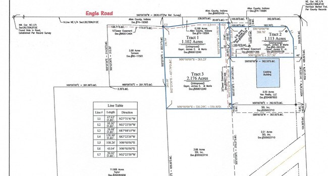
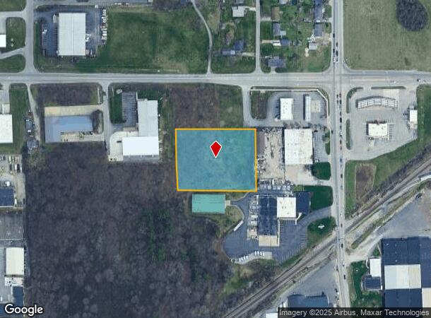
Engle Rd
02-12-20-226-004.003-074
W 330.29 OF E 692.79 OF S 261 OF FRL N 466.5 NE 1/4 SEC 20
Recreationalacreage
Allen
X
Indiana
18003C0290G
1.98 AC
2023
South Fort Wayne
2024
Fort Wayne
011603
Fort Wayne, IN
DEMOGRAPHICS near Engle Rd
1 Mile
3 Mile
5 Mile
2024 Total Population
2,291
47,336
148,803
2029 Population
2,362
49,362
155,724
Pop Growth 2024-2029
+ 3.10%
+ 4.28%
+ 4.65%
Average Age
41
38
37
2024 Total Households
993
20,433
60,763
HH Growth 2024-2029
+ 3.02%
+ 4.28%
+ 4.74%
Median Household Inc
$60,968
$51,869
$49,305
Avg Household Size
2.20
2.20
2.30
2024 Avg HH Vehicles
2.00
2.00
2.00
Median Home Value
$133,377
$137,681
$141,292
Median Year Built
1958
1957
1963
Nearby Places
Map Layers
Map Styles
 Street
 Aerial
- Restaurants
- Banks
- Shops
- Fitness
- Groceries
PUBLIC TRANSPORTATION
AIRPORT
Fort Wayne International
DRIVE
WALK
Distance
Fort Wayne International
13 min
6.3 mi
Freight Ports
Port of Toledo
DRIVE
WALK
Distance
Port of Toledo
148 min
109.9 mi
SALE & LEASE HISTORY
LISTING DATE
SALE/LEASE

Oct 20, 2020
For Sale
Jul 02, 2018
For Sale
Feb 15, 2023
For Sale
Feb 02, 2017
For Sale
Nearby Properties
Address
Land Use
TOTAL SIZE
Lot Size
Zoning
Address
Land Use
TOTAL SIZE
Lot Size
Zoning
725,686 SF
9.45 AC
Address
Land Use
TOTAL SIZE
Lot Size
Zoning
350,680 SF
33.85 AC
Address
Land Use
TOTAL SIZE
Lot Size
Zoning
337,548 SF
39.17 AC
Address
Land Use
TOTAL SIZE
Lot Size
Zoning
703,208 SF
41.90 AC
Address
Land Use
TOTAL SIZE
Lot Size
Zoning
98,361 SF
4.10 AC
Address
Land Use
TOTAL SIZE
Lot Size
Zoning
2.12 AC
Address
Land Use
TOTAL SIZE
Lot Size
Zoning
39,130 SF
6.14 AC
Address
Land Use
TOTAL SIZE
Lot Size
Zoning
143,804 SF
18.88 AC
Address
Land Use
TOTAL SIZE
Lot Size
Zoning
112,234 SF
16.76 AC
Address
Land Use
TOTAL SIZE
Lot Size
Zoning
140,400 SF
11.88 AC
Address
Land Use
TOTAL SIZE
Lot Size
Zoning
248,636 SF
44.24 AC
Address
Land Use
TOTAL SIZE
Lot Size
Zoning
352,058 SF
14.21 AC
Address
Land Use
TOTAL SIZE
Lot Size
Zoning
195,065 SF
13.50 AC
Address
Land Use
TOTAL SIZE
Lot Size
Zoning
55,993 SF
29.20 AC
Address
Land Use
TOTAL SIZE
Lot Size
Zoning
150,600 SF
20.36 AC
Address
Land Use
TOTAL SIZE
Lot Size
Zoning
221,088 SF
42.69 AC
Address
Land Use
TOTAL SIZE
Lot Size
Zoning
174,432 SF
35.29 AC
Address
Land Use
TOTAL SIZE
Lot Size
Zoning
67,749 SF
14.07 AC
Address
Land Use
TOTAL SIZE
Lot Size
Zoning
213,793 SF
20.57 AC
Address
Land Use
TOTAL SIZE
Lot Size
Zoning
92,980 SF
16.22 AC
Address
Land Use
TOTAL SIZE
Lot Size
Zoning
71,290 SF
23.80 AC
Address
Land Use
TOTAL SIZE
Lot Size
Zoning
276,392 SF
19.09 AC
Address
Land Use
TOTAL SIZE
Lot Size
Zoning
170,400 SF
28.17 AC
Address
Land Use
TOTAL SIZE
Lot Size
Zoning
64,080 SF
10 AC
Address
Land Use
TOTAL SIZE
Lot Size
Zoning
53,393 SF
5.41 AC
Address
Land Use
TOTAL SIZE
Lot Size
Zoning
167,836 SF
4.30 AC
Address
Land Use
TOTAL SIZE
Lot Size
Zoning
70,935 SF
20.46 AC
Address
Land Use
TOTAL SIZE
Lot Size
Zoning
117,264 SF
9.37 AC
Address
Land Use
TOTAL SIZE
Lot Size
Zoning
43,122 SF
11.44 AC
Address
Land Use
TOTAL SIZE
Lot Size
Zoning
233,424 SF
16.07 AC
The World's #1 Commercial Real Estate Marketplace
Connect with us
© 2025 CoStar Group
The information above has been obtained from sources believed reliable. While we do not doubt its accuracy we have not verified it and make no guarantee, warranty or representation about it. It is your responsibility to independently confirm its accuracy and completeness. Any projections, opinions, assumptions, or estimates used are for example only and do not represent the current or future performance of the property. The value of this transaction to you depends on tax and other factors which should be evaluated by your tax, financial, and legal advisors. You and your advisors should conduct a careful, independent investigation of the property to determine to your satisfaction the suitability of the property for your needs.