Property Record
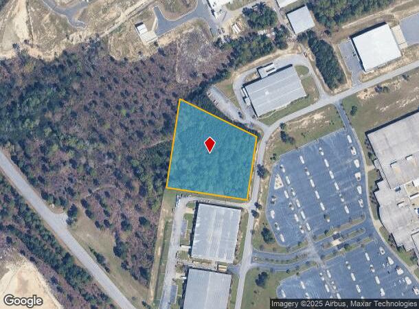
Enterprise Pkwy, West Columbia, SC 29170
Current Lease Availabilities
NEARBY LISTINGS FOR SALE OR LEASE
Property Detail
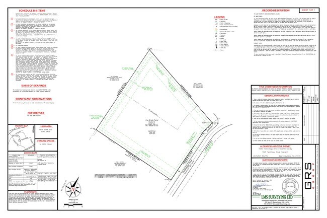
Enterprise Pkwy
005698-03-032
Lexington
Residentialacreage
South Carolina
X
3.37 AC
45063C0259J
Cayce/West Columbia
2025
Columbia
2024
Columbia, SC
980100
DEMOGRAPHICS near Enterprise Pkwy
1 Mile
3 Mile
5 Mile
2024 Total Population
1,537
29,135
86,453
2029 Population
1,691
31,665
94,132
Pop Growth 2024-2029
+ 10.02%
+ 8.68%
+ 8.88%
Average Age
39
40
40
2024 Total Households
630
12,000
36,339
HH Growth 2024-2029
+ 10.00%
+ 8.85%
+ 9.08%
Median Household Inc
$62,329
$64,190
$61,814
Avg Household Size
2.40
2.40
2.30
2024 Avg HH Vehicles
2.00
2.00
2.00
Median Home Value
$148,501
$155,585
$162,257
Median Year Built
1979
1985
1986
Nearby Places
Map Layers
Map Styles
 Street
 Aerial
- Restaurants
- Banks
- Shops
- Fitness
- Groceries
PUBLIC TRANSPORTATION
COMMUTER RAIL
Columbia Amtrak Station (Silver Star - Amtrak)
DRIVE
WALK
Distance
Columbia Amtrak Station (Silver Star - Amtrak)
14 min
7.4 mi
AIRPORT
Columbia Metro
DRIVE
WALK
Distance
Columbia Metro
16 min
4.3 mi
Freight Ports
North Charleston Terminal
DRIVE
WALK
Distance
North Charleston Terminal
119 min
104.1 mi
Nearby Properties
Address
Land Use
TOTAL SIZE
Lot Size
Zoning
Address
Land Use
TOTAL SIZE
Lot Size
Zoning
461,888 SF
61.50 AC
ID
Address
Land Use
TOTAL SIZE
Lot Size
Zoning
3,614 SF
1,444.32 AC
ID
Address
Land Use
TOTAL SIZE
Lot Size
Zoning
222,557 SF
26.90 AC
ID
Address
Land Use
TOTAL SIZE
Lot Size
Zoning
10,304 SF
11.89 AC
R1
Address
Land Use
TOTAL SIZE
Lot Size
Zoning
58.81 AC
RD
Address
Land Use
TOTAL SIZE
Lot Size
Zoning
257,688 SF
23.03 AC
ID
Address
Land Use
TOTAL SIZE
Lot Size
Zoning
41,860 SF
6.54 AC
ID
Address
Land Use
TOTAL SIZE
Lot Size
Zoning
318,309 SF
33.51 AC
ID
Address
Land Use
TOTAL SIZE
Lot Size
Zoning
70,740 SF
13 AC
ID
Address
Land Use
TOTAL SIZE
Lot Size
Zoning
430.11 AC
ID
Address
Land Use
TOTAL SIZE
Lot Size
Zoning
254,399 SF
49.79 AC
ID
Address
Land Use
TOTAL SIZE
Lot Size
Zoning
54,000 SF
8.60 AC
ID
Address
Land Use
TOTAL SIZE
Lot Size
Zoning
147,166 SF
18.27 AC
ID
Address
Land Use
TOTAL SIZE
Lot Size
Zoning
8,269 SF
12.99 AC
RD
Address
Land Use
TOTAL SIZE
Lot Size
Zoning
202,029 SF
21.13 AC
ID
Address
Land Use
TOTAL SIZE
Lot Size
Zoning
10.52 AC
ID
Address
Land Use
TOTAL SIZE
Lot Size
Zoning
115,000 SF
11.99 AC
ID
Address
Land Use
TOTAL SIZE
Lot Size
Zoning
73,778 SF
4.95 AC
A
Address
Land Use
TOTAL SIZE
Lot Size
Zoning
17,442 SF
2.78 AC
Address
Land Use
TOTAL SIZE
Lot Size
Zoning
54,092 SF
5.90 AC
ID
Address
Land Use
TOTAL SIZE
Lot Size
Zoning
95,730 SF
8.15 AC
ID
Address
Land Use
TOTAL SIZE
Lot Size
Zoning
3,250 SF
0.94 AC
ID
Address
Land Use
TOTAL SIZE
Lot Size
Zoning
52,096 SF
10.35 AC
ID
Address
Land Use
TOTAL SIZE
Lot Size
Zoning
29,167 SF
3.15 AC
ID
Address
Land Use
TOTAL SIZE
Lot Size
Zoning
8,030 SF
1.66 AC
C1
Address
Land Use
TOTAL SIZE
Lot Size
Zoning
480 SF
17.33 AC
RD
Address
Land Use
TOTAL SIZE
Lot Size
Zoning
54,883 SF
5.63 AC
ID
Address
Land Use
TOTAL SIZE
Lot Size
Zoning
69,870 SF
13.56 AC
ID
Address
Land Use
TOTAL SIZE
Lot Size
Zoning
35,712 SF
1.74 AC
RS1
Address
Land Use
TOTAL SIZE
Lot Size
Zoning
67,312 SF
2.04 AC
ID
The World's #1 Commercial Real Estate Marketplace
Connect with us
© 2025 CoStar Group
The information above has been obtained from sources believed reliable. While we do not doubt its accuracy we have not verified it and make no guarantee, warranty or representation about it. It is your responsibility to independently confirm its accuracy and completeness. Any projections, opinions, assumptions, or estimates used are for example only and do not represent the current or future performance of the property. The value of this transaction to you depends on tax and other factors which should be evaluated by your tax, financial, and legal advisors. You and your advisors should conduct a careful, independent investigation of the property to determine to your satisfaction the suitability of the property for your needs.