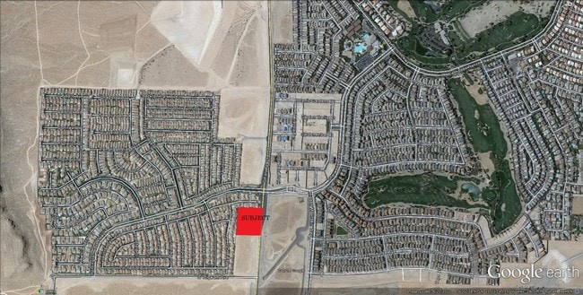
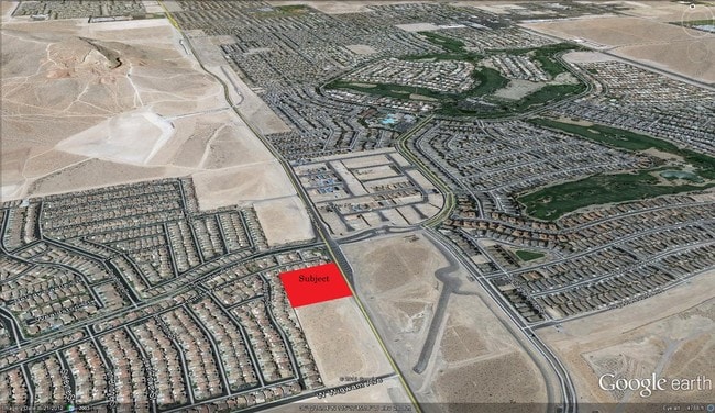
Property Record
8375 S Fort Apache Rd, Las Vegas, NV 89178


Property Detail
8375 S Fort Apache Rd
176-18-601-002
LAND DIVISION 155-80 LAND DIVISION 155-80 LOT 2 & VAC RD
Publicstorage
CLARK
C:C-2
Nevada
B and X Area of moderate flood hazard, usually the area between the limits of the 100-year and 500-year floods.
2
2026
2.20 AC
2026
Southwest Las Vegas
005858
Las Vegas
46,872 SF
Las Vegas-Henderson-North Las Vegas, NV
NEARBY LISTINGS FOR SALE OR LEASE
DEMOGRAPHICS near 8375 S Fort Apache Rd
1 mile
3 mile
5 mile
2025 Total Population
18,325
110,916
241,324
2030 Population
19,535
118,154
256,425
Pop Growth 2025-2030
+ 6.60%
+ 6.53%
+ 6.26%
Average Age
38
38
38
2025 Total Households
6,259
40,435
87,697
HH Growth 2025-2030
+ 6.57%
+ 6.50%
+ 6.28%
Median Household Inc
$105,678
$102,085
$100,287
Avg Household Size
2.90
2.70
2.70
2025 Avg HH Vehicles
2.00
2.00
2.00
Median Home Value
$580,083
$486,959
$487,503
Median Year Built
2009
2008
2007
Nearby Places
Map Layers
Map Styles
 Street
 Aerial
Transit
 Traffic
 Biking
Places
Listings with unknown addresses are not visible on the map
- Restaurants
- Banks
- Shops
- Fitness
- Groceries
PUBLIC TRANSPORTATION
AIRPORT
Harry Reid International
Drive
Walk
Distance
Harry Reid International
18 min
12.4 mi
Boulder City Municipal
Drive
Walk
Distance
Boulder City Municipal
43 min
32.1 mi
Freight Ports
Port of Long Beach
Drive
Walk
Distance
Port of Long Beach
316 min
280.5 mi
SALE & LEASE HISTORY
LISTING DATE
SALE/LEASE

Sep 24, 2016
For Sale
Nearby Properties
Address
Land Use
TOTAL SIZE
Lot Size
Zoning
Address
Land Use
TOTAL SIZE
Lot Size
Zoning
552,417 SF
49.39 AC
H1
Address
Land Use
TOTAL SIZE
Lot Size
Zoning
205,752 SF
36.24 AC
C1
Address
Land Use
TOTAL SIZE
Lot Size
Zoning
760,651 SF
41.25 AC
Address
Land Use
TOTAL SIZE
Lot Size
Zoning
17,206 SF
225 AC
Address
Land Use
TOTAL SIZE
Lot Size
Zoning
29.59 AC
CP
Address
Land Use
TOTAL SIZE
Lot Size
Zoning
Address
Land Use
TOTAL SIZE
Lot Size
Zoning
349,295 SF
25.97 AC
Address
Land Use
TOTAL SIZE
Lot Size
Zoning
8,754 SF
17.14 AC
C2
Address
Land Use
TOTAL SIZE
Lot Size
Zoning
6,142 SF
13.96 AC
C2
Address
Land Use
TOTAL SIZE
Lot Size
Zoning
151,243 SF
22.93 AC
Address
Land Use
TOTAL SIZE
Lot Size
Zoning
35.55 AC
PF
Address
Land Use
TOTAL SIZE
Lot Size
Zoning
12,349 SF
12.50 AC
Address
Land Use
TOTAL SIZE
Lot Size
Zoning
18.62 AC
PF
Address
Land Use
TOTAL SIZE
Lot Size
Zoning
396,742 SF
17.10 AC
Address
Land Use
TOTAL SIZE
Lot Size
Zoning
115,488 SF
6.41 AC
Address
Land Use
TOTAL SIZE
Lot Size
Zoning
3,398 SF
13.56 AC
Address
Land Use
TOTAL SIZE
Lot Size
Zoning
1,961 SF
4.34 AC
Address
Land Use
TOTAL SIZE
Lot Size
Zoning
398,545 SF
20.40 AC
Address
Land Use
TOTAL SIZE
Lot Size
Zoning
107.39 AC
RE
Address
Land Use
TOTAL SIZE
Lot Size
Zoning
7,302 SF
9.21 AC
Address
Land Use
TOTAL SIZE
Lot Size
Zoning
4,382 SF
13.65 AC
C2
Address
Land Use
TOTAL SIZE
Lot Size
Zoning
4,446 SF
14.37 AC
Address
Land Use
TOTAL SIZE
Lot Size
Zoning
3,764 SF
2.78 AC
Address
Land Use
TOTAL SIZE
Lot Size
Zoning
4,718 SF
9.17 AC
R-4
Address
Land Use
TOTAL SIZE
Lot Size
Zoning
9,787 SF
65.73 AC
RE
Address
Land Use
TOTAL SIZE
Lot Size
Zoning
12.18 AC
PF
Address
Land Use
TOTAL SIZE
Lot Size
Zoning
Address
Land Use
TOTAL SIZE
Lot Size
Zoning
126,523 SF
21.55 AC
Address
Land Use
TOTAL SIZE
Lot Size
Zoning
4.37 AC
MLZ
Address
Land Use
TOTAL SIZE
Lot Size
Zoning
86,780 SF
14.58 AC
PF
The World's #1 Commercial Real Estate Marketplace
Connect with us
© 2026 CoStar Group
The information above has been obtained from sources believed reliable. While we do not doubt its accuracy we have not verified it and make no guarantee, warranty or representation about it. It is your responsibility to independently confirm its accuracy and completeness. Any projections, opinions, assumptions, or estimates used are for example only and do not represent the current or future performance of the property. The value of this transaction to you depends on tax and other factors which should be evaluated by your tax, financial, and legal advisors. You and your advisors should conduct a careful, independent investigation of the property to determine to your satisfaction the suitability of the property for your needs.