Property Record
6627 S Old Bastrop Rd, San Marcos, TX 78666


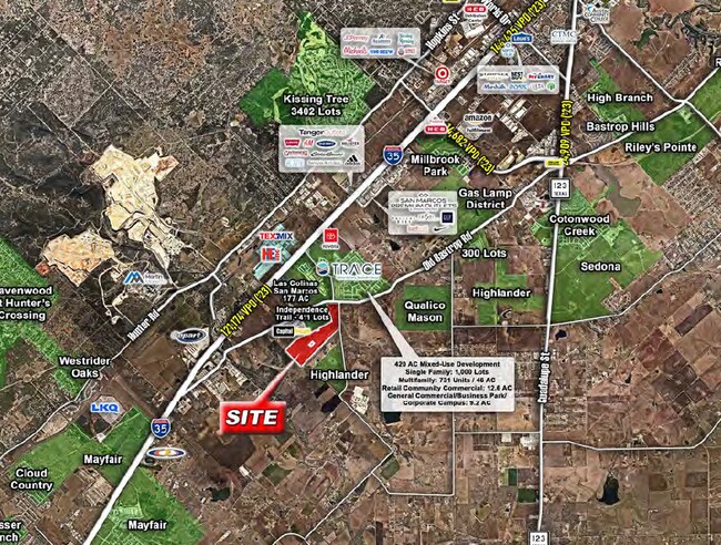
This Property Is For Sale
Property Detail
6627 S Old Bastrop Rd
R10849
A0006 ANTONIO & MARIA ESNANRIZAR SURVEY, ACRES 24.4
Farms
HAYS
B and X Area of moderate flood hazard, usually the area between the limits of the 100-year and 500-year floods.
Texas
2024
24.40 AC
2025
Hays County
010100
Austin
1,064 SF
Austin-Round Rock-San Marcos, TX
NEARBY LISTINGS FOR SALE OR LEASE
DEMOGRAPHICS near 6627 S Old Bastrop Rd
1 mile
3 mile
5 mile
2025 Total Population
635
4,647
25,526
2030 Population
762
5,489
29,998
Pop Growth 2025-2030
+ 20.00%
+ 18.12%
+ 17.52%
Average Age
31
37
39
2025 Total Households
266
1,882
10,087
HH Growth 2025-2030
+ 21.43%
+ 19.34%
+ 18.47%
Median Household Inc
$55,737
$61,480
$69,360
Avg Household Size
2.30
2.40
2.50
2025 Avg HH Vehicles
2.00
2.00
2.00
Median Home Value
$304,545
$328,889
$380,186
Median Year Built
2010
2009
2010
Nearby Places
Map Layers
Map Styles
 Street
 Aerial
Transit
 Traffic
 Biking
Places
Listings with unknown addresses are not visible on the map
- Restaurants
- Banks
- Shops
- Fitness
- Groceries
PUBLIC TRANSPORTATION
COMMUTER RAIL
San Marcos Amtrak (Texas Eagle - Amtrak)
Drive
Walk
Distance
San Marcos Amtrak (Texas Eagle - Amtrak)
3 min
1.3 mi
AIRPORT
Austin-Bergstrom International
Drive
Walk
Distance
Austin-Bergstrom International
49 min
36.8 mi
Freight Ports
Calhoun Port
Drive
Walk
Distance
Calhoun Port
166 min
136.2 mi
Nearby Properties
Address
Land Use
TOTAL SIZE
Lot Size
Zoning
Address
Land Use
TOTAL SIZE
Lot Size
Zoning
623,823 SF
1.46 AC
Address
Land Use
TOTAL SIZE
Lot Size
Zoning
855,000 SF
95.65 AC
Address
Land Use
TOTAL SIZE
Lot Size
Zoning
215,932 SF
3.67 AC
Address
Land Use
TOTAL SIZE
Lot Size
Zoning
419,973 SF
23.69 AC
Address
Land Use
TOTAL SIZE
Lot Size
Zoning
324,430 SF
23.60 AC
Address
Land Use
TOTAL SIZE
Lot Size
Zoning
479,270 SF
24.78 AC
Address
Land Use
TOTAL SIZE
Lot Size
Zoning
458,948 SF
35.43 AC
Address
Land Use
TOTAL SIZE
Lot Size
Zoning
402,983 SF
21.31 AC
Address
Land Use
TOTAL SIZE
Lot Size
Zoning
343,094 SF
39.30 AC
Address
Land Use
TOTAL SIZE
Lot Size
Zoning
545,643 SF
2.69 AC
Address
Land Use
TOTAL SIZE
Lot Size
Zoning
279,131 SF
22.46 AC
Address
Land Use
TOTAL SIZE
Lot Size
Zoning
466,968 SF
15.19 AC
Address
Land Use
TOTAL SIZE
Lot Size
Zoning
311,146 SF
5.11 AC
Address
Land Use
TOTAL SIZE
Lot Size
Zoning
352,285 SF
12.75 AC
Address
Land Use
TOTAL SIZE
Lot Size
Zoning
283,033 SF
19.46 AC
Address
Land Use
TOTAL SIZE
Lot Size
Zoning
327,917 SF
10.54 AC
Address
Land Use
TOTAL SIZE
Lot Size
Zoning
266,157 SF
14.70 AC
Address
Land Use
TOTAL SIZE
Lot Size
Zoning
365,750 SF
19.65 AC
Address
Land Use
TOTAL SIZE
Lot Size
Zoning
184,438 SF
12.57 AC
Address
Land Use
TOTAL SIZE
Lot Size
Zoning
255,621 SF
8.83 AC
Address
Land Use
TOTAL SIZE
Lot Size
Zoning
277,659 SF
10.77 AC
Address
Land Use
TOTAL SIZE
Lot Size
Zoning
307,962 SF
14.23 AC
Address
Land Use
TOTAL SIZE
Lot Size
Zoning
215,688 SF
10.36 AC
Address
Land Use
TOTAL SIZE
Lot Size
Zoning
24.14 AC
Address
Land Use
TOTAL SIZE
Lot Size
Zoning
179,764 SF
3.27 AC
Address
Land Use
TOTAL SIZE
Lot Size
Zoning
145,336 SF
0.87 AC
Address
Land Use
TOTAL SIZE
Lot Size
Zoning
195,018 SF
7.37 AC
Address
Land Use
TOTAL SIZE
Lot Size
Zoning
185,184 SF
11.22 AC
Address
Land Use
TOTAL SIZE
Lot Size
Zoning
233,640 SF
12.99 AC
Address
Land Use
TOTAL SIZE
Lot Size
Zoning
305,644 SF
27.93 AC
The World's #1 Commercial Real Estate Marketplace
Connect with us
© 2026 CoStar Group
The information above has been obtained from sources believed reliable. While we do not doubt its accuracy we have not verified it and make no guarantee, warranty or representation about it. It is your responsibility to independently confirm its accuracy and completeness. Any projections, opinions, assumptions, or estimates used are for example only and do not represent the current or future performance of the property. The value of this transaction to you depends on tax and other factors which should be evaluated by your tax, financial, and legal advisors. You and your advisors should conduct a careful, independent investigation of the property to determine to your satisfaction the suitability of the property for your needs.