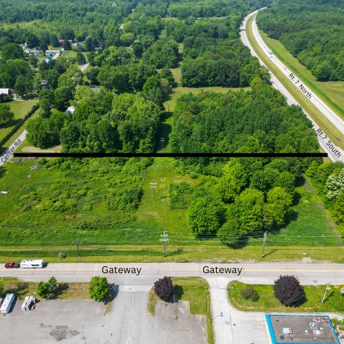
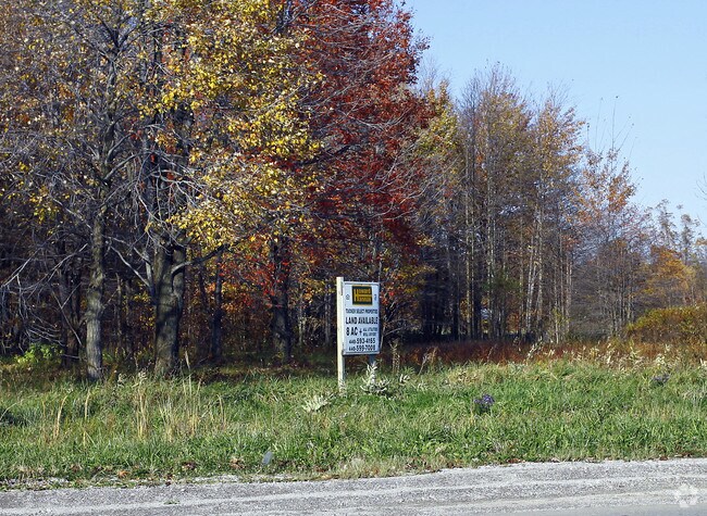
Property Record
584 Center Rd, Conneaut, OH 44030

Save to a Folder
{{folder.Name}}
{{folder.ListingIds.length}} Properties
{{folder.ListingIds.length}} Property
Create a New Folder
Property Detail
584 Center Rd
Cleveland-Elyria, OH
T 13--63 S E
123130007200
Ashtabula
Farms
Ohio
B and X Area of moderate flood hazard, usually the area between the limits of the 100-year and 500-year floods.
63
2025
11.40 AC
2025
Ashtabula County
000101
Cleveland
2,284 SF
NEARBY LISTINGS FOR SALE OR LEASE
DEMOGRAPHICS near 584 Center Rd
1 mile
3 mile
5 mile
2025 Total Population
395
13,111
16,018
2030 Population
396
13,230
16,104
Pop Growth 2025-2030
+ 0.25%
+ 0.91%
+ 0.54%
Average Age
43
42
43
2025 Total Households
176
4,921
6,112
HH Growth 2025-2030
0.00%
+ 0.91%
+ 0.52%
Median Household Inc
$56,428
$51,427
$56,272
Avg Household Size
2.10
2.20
2.20
2025 Avg HH Vehicles
2.00
2.00
2.00
Median Home Value
$150,892
$134,672
$144,632
Median Year Built
1952
1949
1952
Nearby Places
Map Layers
Map Styles
 Street
 Aerial
Layers
 Traffic
 Biking
Places
Listings with unknown addresses are not visible on the map
- Restaurants
- Banks
- Shops
- Fitness
- Groceries
PUBLIC TRANSPORTATION
AIRPORT
Erie International/Tom Ridge Field
Drive
Walk
Distance
Erie International/Tom Ridge Field
39 min
27.9 mi
Freight Ports
Port of Toledo
Drive
Walk
Distance
Port of Toledo
214 min
183.0 mi
SALE & LEASE HISTORY
LISTING DATE
SALE/LEASE

Sep 24, 2016
For Sale
Sep 24, 2016
For Sale
Oct 03, 2019
For Sale
Jun 20, 2024
For Sale
Jun 20, 2024
For Sale
Jan 25, 2017
For Sale
Nearby Properties
Address
Land Use
TOTAL SIZE
Lot Size
Zoning
Address
Land Use
TOTAL SIZE
Lot Size
Zoning
196,866 SF
119.64 AC
Address
Land Use
TOTAL SIZE
Lot Size
Zoning
Address
Land Use
TOTAL SIZE
Lot Size
Zoning
94,656 SF
27.89 AC
Address
Land Use
TOTAL SIZE
Lot Size
Zoning
Address
Land Use
TOTAL SIZE
Lot Size
Zoning
78,100 SF
7.28 AC
Address
Land Use
TOTAL SIZE
Lot Size
Zoning
0.09 AC
Address
Land Use
TOTAL SIZE
Lot Size
Zoning
70,523 SF
17.69 AC
Address
Land Use
TOTAL SIZE
Lot Size
Zoning
105,869 SF
6.90 AC
Address
Land Use
TOTAL SIZE
Lot Size
Zoning
64,728 SF
21.53 AC
Address
Land Use
TOTAL SIZE
Lot Size
Zoning
213,400 SF
10.02 AC
Address
Land Use
TOTAL SIZE
Lot Size
Zoning
5,607 SF
16.41 AC
Address
Land Use
TOTAL SIZE
Lot Size
Zoning
254,037 SF
16.47 AC
Address
Land Use
TOTAL SIZE
Lot Size
Zoning
57,714 SF
8.65 AC
Address
Land Use
TOTAL SIZE
Lot Size
Zoning
202,939 SF
36.27 AC
Address
Land Use
TOTAL SIZE
Lot Size
Zoning
1.01 AC
Address
Land Use
TOTAL SIZE
Lot Size
Zoning
Address
Land Use
TOTAL SIZE
Lot Size
Zoning
Address
Land Use
TOTAL SIZE
Lot Size
Zoning
102,157 SF
10 AC
Address
Land Use
TOTAL SIZE
Lot Size
Zoning
75,074 SF
5.61 AC
Address
Land Use
TOTAL SIZE
Lot Size
Zoning
98,857 SF
18.62 AC
Address
Land Use
TOTAL SIZE
Lot Size
Zoning
16,103 SF
12.65 AC
Address
Land Use
TOTAL SIZE
Lot Size
Zoning
110,576 SF
17.91 AC
Address
Land Use
TOTAL SIZE
Lot Size
Zoning
31,756 SF
4.34 AC
Address
Land Use
TOTAL SIZE
Lot Size
Zoning
24,142 SF
11.46 AC
Address
Land Use
TOTAL SIZE
Lot Size
Zoning
53,569 SF
8.83 AC
Address
Land Use
TOTAL SIZE
Lot Size
Zoning
16,680 SF
0.90 AC
Address
Land Use
TOTAL SIZE
Lot Size
Zoning
47,480 SF
0.53 AC
Address
Land Use
TOTAL SIZE
Lot Size
Zoning
52,436 SF
5.82 AC
Address
Land Use
TOTAL SIZE
Lot Size
Zoning
83,400 SF
12.13 AC
Address
Land Use
TOTAL SIZE
Lot Size
Zoning
160,414 SF
10.69 AC
The World's #1 Commercial Real Estate Marketplace
Connect with us
© 2026 CoStar Group
The information above has been obtained from sources believed reliable. While we do not doubt its accuracy we have not verified it and make no guarantee, warranty or representation about it. It is your responsibility to independently confirm its accuracy and completeness. Any projections, opinions, assumptions, or estimates used are for example only and do not represent the current or future performance of the property. The value of this transaction to you depends on tax and other factors which should be evaluated by your tax, financial, and legal advisors. You and your advisors should conduct a careful, independent investigation of the property to determine to your satisfaction the suitability of the property for your needs.