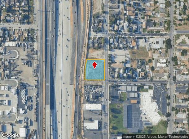
Property Record
H St, San Bernardino, CA 92405
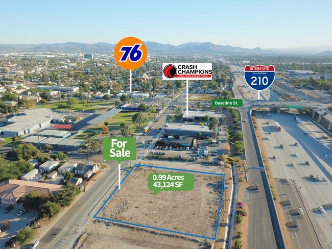
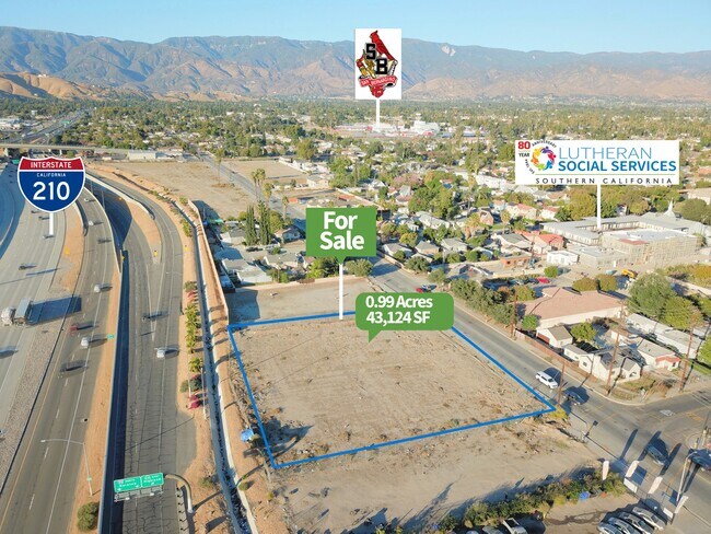
This Property Is For Sale
NEARBY LISTINGS FOR SALE OR LEASE
Property Detail
H St
Riverside-San Bernardino-Ontario, CA
THAT PORTION OF LOT 10, BLOCK 36, RANCHO SAN BERNARDINO, AS PER MAP RECORDED IN BOOK 7 OF MAPS, PAGE 2, RECORDS OF SAN BERNARDINO COUNTY, DESCRIBED AS FOLLOWS: BEGINNING AT THE INTERSECTION OF A LINE THAT IS 30 FEET NORTHERLY, MEASURED AT RIGHT ANGLE
0145-192-61
San Bernardino
Vacantlandnec
California
X
10
06071C8681J
0.99 AC
2024
San Bernardino
2025
Inland Empire (California)
005300
DEMOGRAPHICS near H St
1 Mile
3 Mile
5 Mile
2024 Total Population
27,241
157,528
369,004
2029 Population
27,568
159,709
374,599
Pop Growth 2024-2029
+ 1.20%
+ 1.38%
+ 1.52%
Average Age
33
34
34
2024 Total Households
7,404
43,725
101,784
HH Growth 2024-2029
+ 1.28%
+ 1.48%
+ 1.57%
Median Household Inc
$44,399
$50,505
$59,933
Avg Household Size
3.50
3.40
3.50
2024 Avg HH Vehicles
2.00
2.00
2.00
Median Home Value
$275,736
$305,171
$343,192
Median Year Built
1957
1961
1968
Nearby Places
Map Layers
Map Styles
 Street
 Aerial
- Restaurants
- Banks
- Shops
- Fitness
- Groceries
PUBLIC TRANSPORTATION
COMMUTER RAIL
San Bernardino (Inland Empire-Orange County Line - Southern California Regional Rail Authority (Metrolink), San Bernardino Line - Southern California Regional Rail Authority (Metrolink))
DRIVE
WALK
Distance
San Bernardino (Inland Empire-Orange County Line - Southern California Regional Rail Authority (Metrolink), San Bernardino Line - Southern California Regional Rail Authority (Metrolink))
5 min
2.1 mi
DRIVE
WALK
Distance
6 min
2.2 mi
AIRPORT
Ontario International
DRIVE
WALK
Distance
Ontario International
31 min
23.3 mi
Nearby Properties
Address
Land Use
TOTAL SIZE
Lot Size
Zoning
Address
Land Use
TOTAL SIZE
Lot Size
Zoning
778,653 SF
19.31 AC
Address
Land Use
TOTAL SIZE
Lot Size
Zoning
497,664 SF
56.39 AC
Address
Land Use
TOTAL SIZE
Lot Size
Zoning
330,420 SF
15.31 AC
Address
Land Use
TOTAL SIZE
Lot Size
Zoning
379,299 SF
19.97 AC
Address
Land Use
TOTAL SIZE
Lot Size
Zoning
758,180 SF
31.86 AC
Address
Land Use
TOTAL SIZE
Lot Size
Zoning
1,205,400 SF
58.05 AC
Address
Land Use
TOTAL SIZE
Lot Size
Zoning
206,244 SF
15.22 AC
Address
Land Use
TOTAL SIZE
Lot Size
Zoning
801,377 SF
20.81 AC
Address
Land Use
TOTAL SIZE
Lot Size
Zoning
472,962 SF
23.28 AC
Address
Land Use
TOTAL SIZE
Lot Size
Zoning
178,926 SF
9.12 AC
IC
Address
Land Use
TOTAL SIZE
Lot Size
Zoning
277,822 SF
13.65 AC
Address
Land Use
TOTAL SIZE
Lot Size
Zoning
335,000 SF
8.44 AC
Address
Land Use
TOTAL SIZE
Lot Size
Zoning
151,859 SF
7.23 AC
Address
Land Use
TOTAL SIZE
Lot Size
Zoning
415,405 SF
18.43 AC
IC
Address
Land Use
TOTAL SIZE
Lot Size
Zoning
592,710 SF
28.89 AC
Address
Land Use
TOTAL SIZE
Lot Size
Zoning
354,108 SF
16.93 AC
Address
Land Use
TOTAL SIZE
Lot Size
Zoning
599,690 SF
17.08 AC
IC
Address
Land Use
TOTAL SIZE
Lot Size
Zoning
24.24 AC
Address
Land Use
TOTAL SIZE
Lot Size
Zoning
413,953 SF
19.58 AC
Address
Land Use
TOTAL SIZE
Lot Size
Zoning
159,956 SF
9.20 AC
Address
Land Use
TOTAL SIZE
Lot Size
Zoning
345,237 SF
14.52 AC
Address
Land Use
TOTAL SIZE
Lot Size
Zoning
166,376 SF
18.75 AC
Address
Land Use
TOTAL SIZE
Lot Size
Zoning
350,939 SF
6.29 AC
Address
Land Use
TOTAL SIZE
Lot Size
Zoning
179,550 SF
8.04 AC
Address
Land Use
TOTAL SIZE
Lot Size
Zoning
Address
Land Use
TOTAL SIZE
Lot Size
Zoning
8,200 SF
11.29 AC
Address
Land Use
TOTAL SIZE
Lot Size
Zoning
190,704 SF
6.39 AC
Address
Land Use
TOTAL SIZE
Lot Size
Zoning
448,460 SF
24.10 AC
Address
Land Use
TOTAL SIZE
Lot Size
Zoning
55,432 SF
5.31 AC
Address
Land Use
TOTAL SIZE
Lot Size
Zoning
146,800 SF
6.21 AC
The World's #1 Commercial Real Estate Marketplace
Connect with us
© 2025 CoStar Group
The information above has been obtained from sources believed reliable. While we do not doubt its accuracy we have not verified it and make no guarantee, warranty or representation about it. It is your responsibility to independently confirm its accuracy and completeness. Any projections, opinions, assumptions, or estimates used are for example only and do not represent the current or future performance of the property. The value of this transaction to you depends on tax and other factors which should be evaluated by your tax, financial, and legal advisors. You and your advisors should conduct a careful, independent investigation of the property to determine to your satisfaction the suitability of the property for your needs.