Property Record
Hampton Rd, Cherry Hill, NJ 08002
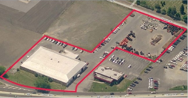
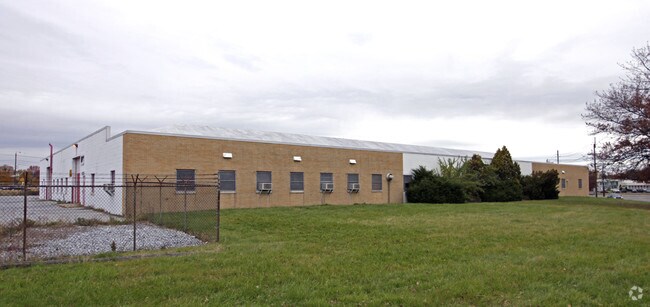
Property Detail
Hampton Rd
Philadelphia-Camden-Wilmington, PA-NJ-DE-MD
CAMDEN
09-00065-01-00005
New Jersey
Commercialnec
3
B and X Area of moderate flood hazard, usually the area between the limits of the 100-year and 500-year floods.
1.20 AC
2025
Camden County
2025
Philadelphia
603202
NEARBY LISTINGS FOR SALE OR LEASE
DEMOGRAPHICS near Hampton Rd
1 mile
3 mile
5 mile
2025 Total Population
10,954
166,224
361,826
2030 Population
11,127
170,264
369,405
Pop Growth 2025-2030
+ 1.58%
+ 2.43%
+ 2.09%
Average Age
42
39
39
2025 Total Households
4,643
62,871
143,391
HH Growth 2025-2030
+ 1.68%
+ 2.44%
+ 2.02%
Median Household Inc
$90,561
$79,480
$83,418
Avg Household Size
2.30
2.60
2.40
2025 Avg HH Vehicles
2.00
2.00
2.00
Median Home Value
$321,889
$293,402
$303,568
Median Year Built
1956
1953
1954
Nearby Places
Map Layers
Map Styles
 Street
 Aerial
Layers
 Traffic
 Biking
Places
Listings with unknown addresses are not visible on the map
- Restaurants
- Banks
- Shops
- Fitness
- Groceries
PUBLIC TRANSPORTATION
COMMUTER RAIL
Cherry Hill (Atlantic City Line - NJ Transit Commuter Rail (NJ Transit))
Drive
Walk
Distance
Cherry Hill (Atlantic City Line - NJ Transit Commuter Rail (NJ Transit))
4 min
1.8 mi
Pennsauken Transit Center (Atlantic City Rail Line - NJ TRANSIT RAIL)
Drive
Walk
Distance
Pennsauken Transit Center (Atlantic City Rail Line - NJ TRANSIT RAIL)
8 min
4.0 mi
AIRPORT
Philadelphia International
Drive
Walk
Distance
Philadelphia International
25 min
14.6 mi
Trenton Mercer
Drive
Walk
Distance
Trenton Mercer
50 min
35.5 mi
Freight Ports
Broadway Terminal - Pier 5
Drive
Walk
Distance
Broadway Terminal - Pier 5
9 min
5.1 mi
Nearby Properties
Address
Land Use
TOTAL SIZE
Lot Size
Zoning
Address
Land Use
TOTAL SIZE
Lot Size
Zoning
66.02 AC
Address
Land Use
TOTAL SIZE
Lot Size
Zoning
Address
Land Use
TOTAL SIZE
Lot Size
Zoning
Address
Land Use
TOTAL SIZE
Lot Size
Zoning
12.53 AC
Address
Land Use
TOTAL SIZE
Lot Size
Zoning
Address
Land Use
TOTAL SIZE
Lot Size
Zoning
20.13 AC
Address
Land Use
TOTAL SIZE
Lot Size
Zoning
7.11 AC
Address
Land Use
TOTAL SIZE
Lot Size
Zoning
49.16 AC
Address
Land Use
TOTAL SIZE
Lot Size
Zoning
10,292 SF
21.30 AC
Address
Land Use
TOTAL SIZE
Lot Size
Zoning
8.50 AC
Address
Land Use
TOTAL SIZE
Lot Size
Zoning
Address
Land Use
TOTAL SIZE
Lot Size
Zoning
37.60 AC
Address
Land Use
TOTAL SIZE
Lot Size
Zoning
Address
Land Use
TOTAL SIZE
Lot Size
Zoning
12.80 AC
R20
Address
Land Use
TOTAL SIZE
Lot Size
Zoning
31.99 AC
Address
Land Use
TOTAL SIZE
Lot Size
Zoning
16,872 SF
RH
Address
Land Use
TOTAL SIZE
Lot Size
Zoning
1,504 SF
61.44 AC
Address
Land Use
TOTAL SIZE
Lot Size
Zoning
39,080 SF
18.60 AC
C2
Address
Land Use
TOTAL SIZE
Lot Size
Zoning
1.48 AC
PCR
Address
Land Use
TOTAL SIZE
Lot Size
Zoning
17.62 AC
Address
Land Use
TOTAL SIZE
Lot Size
Zoning
35 AC
R1
Address
Land Use
TOTAL SIZE
Lot Size
Zoning
14.11 AC
RG
Address
Land Use
TOTAL SIZE
Lot Size
Zoning
12.68 AC
RG
Address
Land Use
TOTAL SIZE
Lot Size
Zoning
16,796 SF
RH
Address
Land Use
TOTAL SIZE
Lot Size
Zoning
50,464 SF
20.22 AC
RH
Address
Land Use
TOTAL SIZE
Lot Size
Zoning
2.32 AC
Address
Land Use
TOTAL SIZE
Lot Size
Zoning
Address
Land Use
TOTAL SIZE
Lot Size
Zoning
27.83 AC
Address
Land Use
TOTAL SIZE
Lot Size
Zoning
5.23 AC
Address
Land Use
TOTAL SIZE
Lot Size
Zoning
4.10 AC
The World's #1 Commercial Real Estate Marketplace
Connect with us
© 2026 CoStar Group
The information above has been obtained from sources believed reliable. While we do not doubt its accuracy we have not verified it and make no guarantee, warranty or representation about it. It is your responsibility to independently confirm its accuracy and completeness. Any projections, opinions, assumptions, or estimates used are for example only and do not represent the current or future performance of the property. The value of this transaction to you depends on tax and other factors which should be evaluated by your tax, financial, and legal advisors. You and your advisors should conduct a careful, independent investigation of the property to determine to your satisfaction the suitability of the property for your needs.