Property Record
Harry Mccarty Rd, Bethlehem, GA 30620

NEARBY LISTINGS FOR SALE OR LEASE
Property Detail
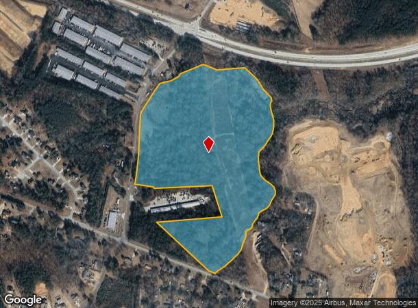
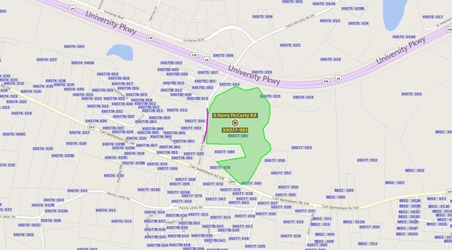
Harry Mccarty Rd
XX077-081
HARRY MCCARTY RD
Agriculturalland
Barrow
A
Georgia
13297C0040E
39.60 AC
2024
Barrow County
2024
Atlanta
180503
Atlanta-Sandy Springs-Roswell, GA
DEMOGRAPHICS near Harry Mccarty Rd
1 Mile
3 Mile
5 Mile
2024 Total Population
1,722
17,198
46,075
2029 Population
2,006
20,113
53,635
Pop Growth 2024-2029
+ 16.49%
+ 16.95%
+ 16.41%
Average Age
36
35
37
2024 Total Households
586
5,571
15,616
HH Growth 2024-2029
+ 16.55%
+ 17.09%
+ 16.59%
Median Household Inc
$57,391
$66,618
$65,473
Avg Household Size
2.90
3.00
2.90
2024 Avg HH Vehicles
2.00
2.00
2.00
Median Home Value
$227,124
$209,440
$216,547
Median Year Built
1998
2002
1999
Nearby Places
Map Layers
Map Styles
 Street
 Aerial
- Restaurants
- Banks
- Shops
- Fitness
- Groceries
SALE & LEASE HISTORY
LISTING DATE
SALE/LEASE

Sep 05, 2017
For Sale
Mar 28, 2017
For Sale
Nearby Properties
Address
Land Use
TOTAL SIZE
Lot Size
Zoning
Address
Land Use
TOTAL SIZE
Lot Size
Zoning
1,456 SF
1,732.80 AC
G
Address
Land Use
TOTAL SIZE
Lot Size
Zoning
26,789 SF
35.60 AC
C-3
Address
Land Use
TOTAL SIZE
Lot Size
Zoning
22,320 SF
15.90 AC
R-3
Address
Land Use
TOTAL SIZE
Lot Size
Zoning
2,046 SF
13 AC
B-2,R-3
Address
Land Use
TOTAL SIZE
Lot Size
Zoning
132,156 SF
10.10 AC
C-2
Address
Land Use
TOTAL SIZE
Lot Size
Zoning
79,029 SF
9.70 AC
C-2
Address
Land Use
TOTAL SIZE
Lot Size
Zoning
37,162 SF
4.60 AC
R-3
Address
Land Use
TOTAL SIZE
Lot Size
Zoning
104,805 SF
12.50 AC
C-3
Address
Land Use
TOTAL SIZE
Lot Size
Zoning
3,370 SF
352.40 AC
G,TNPD
Address
Land Use
TOTAL SIZE
Lot Size
Zoning
1,188 SF
7.60 AC
R-3
Address
Land Use
TOTAL SIZE
Lot Size
Zoning
55,420 SF
5 AC
C-3
Address
Land Use
TOTAL SIZE
Lot Size
Zoning
26,802 SF
5 AC
AG
Address
Land Use
TOTAL SIZE
Lot Size
Zoning
24,982 SF
16.10 AC
R-1
Address
Land Use
TOTAL SIZE
Lot Size
Zoning
46,339 SF
2 AC
B-2
Address
Land Use
TOTAL SIZE
Lot Size
Zoning
76,768 SF
19 AC
AG
Address
Land Use
TOTAL SIZE
Lot Size
Zoning
45,296 SF
8.20 AC
B-2
Address
Land Use
TOTAL SIZE
Lot Size
Zoning
143,025 SF
9.30 AC
M-1
Address
Land Use
TOTAL SIZE
Lot Size
Zoning
19,483 SF
2.80 AC
B-2
Address
Land Use
TOTAL SIZE
Lot Size
Zoning
2,398 SF
8.10 AC
R-3
Address
Land Use
TOTAL SIZE
Lot Size
Zoning
49,920 SF
24.50 AC
AG
Address
Land Use
TOTAL SIZE
Lot Size
Zoning
18,240 SF
0.93 AC
B-2
Address
Land Use
TOTAL SIZE
Lot Size
Zoning
5,500 SF
12.90 AC
C-3
Address
Land Use
TOTAL SIZE
Lot Size
Zoning
14,300 SF
5.80 AC
M-1
Address
Land Use
TOTAL SIZE
Lot Size
Zoning
4,026 SF
1.60 AC
B-2
Address
Land Use
TOTAL SIZE
Lot Size
Zoning
47,130 SF
17.60 AC
M-1
Address
Land Use
TOTAL SIZE
Lot Size
Zoning
21,514 SF
0.50 AC
B-2
Address
Land Use
TOTAL SIZE
Lot Size
Zoning
14,356 SF
2.30 AC
B-2
Address
Land Use
TOTAL SIZE
Lot Size
Zoning
1,395 SF
0.16 AC
HPM2*
Address
Land Use
TOTAL SIZE
Lot Size
Zoning
13,439 SF
1.30 AC
B-2
Address
Land Use
TOTAL SIZE
Lot Size
Zoning
14.70 AC
C-2
The World's #1 Commercial Real Estate Marketplace
Connect with us
© 2025 CoStar Group
The information above has been obtained from sources believed reliable. While we do not doubt its accuracy we have not verified it and make no guarantee, warranty or representation about it. It is your responsibility to independently confirm its accuracy and completeness. Any projections, opinions, assumptions, or estimates used are for example only and do not represent the current or future performance of the property. The value of this transaction to you depends on tax and other factors which should be evaluated by your tax, financial, and legal advisors. You and your advisors should conduct a careful, independent investigation of the property to determine to your satisfaction the suitability of the property for your needs.