Property Record
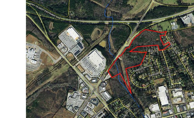
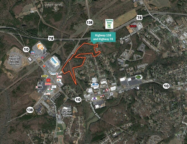
830 Highway 138 Blvd, Monroe, GA 30655

Property Detail
830 Highway 138 Blvd
M006000000017000
34.68AC
Governmentalpublicusegeneral
WALTON
B3
Georgia
AE The base floodplain where base flood elevations are provided. AE Zones are now used on new format FIRMs instead of A1-A30 Zones.
0
0
34.68 AC
2025
Walton County
110702
Atlanta
898 SF
Atlanta-Sandy Springs-Roswell, GA
NEARBY LISTINGS FOR SALE OR LEASE
DEMOGRAPHICS near 830 Highway 138 Blvd
1 mile
3 mile
5 mile
2025 Total Population
2,291
22,309
38,496
2030 Population
2,536
24,914
43,033
Pop Growth 2025-2030
+ 10.69%
+ 11.68%
+ 11.79%
Average Age
37
39
40
2025 Total Households
950
8,381
14,095
HH Growth 2025-2030
+ 10.84%
+ 11.79%
+ 11.88%
Median Household Inc
$40,199
$46,904
$62,781
Avg Household Size
2.40
2.60
2.70
2025 Avg HH Vehicles
2.00
2.00
2.00
Median Home Value
$319,444
$314,208
$331,987
Median Year Built
1982
1988
1993
Nearby Places
Map Layers
Map Styles
 Street
 Aerial
Transit
 Traffic
 Biking
Places
Listings with unknown addresses are not visible on the map
- Restaurants
- Banks
- Shops
- Fitness
- Groceries
SALE & LEASE HISTORY
LISTING DATE
SALE/LEASE

Jan 13, 2020
For Sale
Aug 04, 2017
For Sale
Nearby Properties
Address
Land Use
TOTAL SIZE
Lot Size
Zoning
Address
Land Use
TOTAL SIZE
Lot Size
Zoning
63,172 SF
226.40 AC
R1 P
Address
Land Use
TOTAL SIZE
Lot Size
Zoning
117,471 SF
65.68 AC
B3
Address
Land Use
TOTAL SIZE
Lot Size
Zoning
113,162 SF
26.22 AC
PCD
Address
Land Use
TOTAL SIZE
Lot Size
Zoning
35,900 SF
44.30 AC
B3
Address
Land Use
TOTAL SIZE
Lot Size
Zoning
9,424 SF
76 AC
MIX WP2
Address
Land Use
TOTAL SIZE
Lot Size
Zoning
185,112 SF
26.38 AC
PCD
Address
Land Use
TOTAL SIZE
Lot Size
Zoning
122,949 SF
28.37 AC
R1 P
Address
Land Use
TOTAL SIZE
Lot Size
Zoning
188,663 SF
25.40 AC
B3
Address
Land Use
TOTAL SIZE
Lot Size
Zoning
235.08 AC
B3 R1
Address
Land Use
TOTAL SIZE
Lot Size
Zoning
2,736 SF
8.96 AC
P
Address
Land Use
TOTAL SIZE
Lot Size
Zoning
96,107 SF
58.49 AC
R1
Address
Land Use
TOTAL SIZE
Lot Size
Zoning
72,434 SF
14.12 AC
B3
Address
Land Use
TOTAL SIZE
Lot Size
Zoning
29,161 SF
42.44 AC
B2 R1 R2
Address
Land Use
TOTAL SIZE
Lot Size
Zoning
4,319 SF
12.16 AC
PRD
Address
Land Use
TOTAL SIZE
Lot Size
Zoning
78,644 SF
9.90 AC
B3
Address
Land Use
TOTAL SIZE
Lot Size
Zoning
58,980 SF
8.84 AC
PCD
Address
Land Use
TOTAL SIZE
Lot Size
Zoning
39,385 SF
38.48 AC
B3
Address
Land Use
TOTAL SIZE
Lot Size
Zoning
104,716 SF
11.70 AC
B3
Address
Land Use
TOTAL SIZE
Lot Size
Zoning
2,640 SF
64.81 AC
R1A
Address
Land Use
TOTAL SIZE
Lot Size
Zoning
2,900 SF
30.02 AC
M1
Address
Land Use
TOTAL SIZE
Lot Size
Zoning
52,185 SF
3.64 AC
PCD
Address
Land Use
TOTAL SIZE
Lot Size
Zoning
27,300 SF
8 AC
PCD
Address
Land Use
TOTAL SIZE
Lot Size
Zoning
11,215 SF
7.46 AC
B1
Address
Land Use
TOTAL SIZE
Lot Size
Zoning
45,428 SF
8.11 AC
B3
Address
Land Use
TOTAL SIZE
Lot Size
Zoning
25,192 SF
20.20 AC
A2
Address
Land Use
TOTAL SIZE
Lot Size
Zoning
90,557 SF
11.46 AC
B3
Address
Land Use
TOTAL SIZE
Lot Size
Zoning
104,104 SF
17.55 AC
R1A
Address
Land Use
TOTAL SIZE
Lot Size
Zoning
37,600 SF
5.96 AC
B2
Address
Land Use
TOTAL SIZE
Lot Size
Zoning
3,321 SF
9.58 AC
M1
Address
Land Use
TOTAL SIZE
Lot Size
Zoning
3,912 SF
221.14 AC
MIX
The World's #1 Commercial Real Estate Marketplace
Connect with us
© 2026 CoStar Group
The information above has been obtained from sources believed reliable. While we do not doubt its accuracy we have not verified it and make no guarantee, warranty or representation about it. It is your responsibility to independently confirm its accuracy and completeness. Any projections, opinions, assumptions, or estimates used are for example only and do not represent the current or future performance of the property. The value of this transaction to you depends on tax and other factors which should be evaluated by your tax, financial, and legal advisors. You and your advisors should conduct a careful, independent investigation of the property to determine to your satisfaction the suitability of the property for your needs.