Property Record
Highway 191, Midland, TX 79707
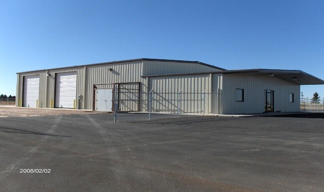

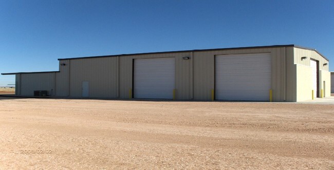
Property Detail
Highway 191
Midland, TX
ACRES: 296.646 SEC: 39 BLK: 40-T1S
R000007-501
MIDLAND
Ranch
Texas
2025
296.65 AC
2025
Midland & Odessa
010120
Other Market Areas
NEARBY LISTINGS FOR SALE OR LEASE
DEMOGRAPHICS near Highway 191
1 mile
3 mile
5 mile
2025 Total Population
681
20,242
76,969
2030 Population
760
22,523
84,716
Pop Growth 2025-2030
+ 11.60%
+ 11.27%
+ 10.07%
Average Age
32
34
35
2025 Total Households
232
7,262
28,577
HH Growth 2025-2030
+ 12.50%
+ 12.48%
+ 11.32%
Median Household Inc
$104,573
$117,001
$90,730
Avg Household Size
2.90
2.80
2.60
2025 Avg HH Vehicles
2.00
2.00
2.00
Median Home Value
$341,279
$366,367
$314,159
Median Year Built
2010
2007
1987
Nearby Places
Map Layers
Map Styles
 Street
 Aerial
Transit
 Traffic
 Biking
Places
Listings with unknown addresses are not visible on the map
- Restaurants
- Banks
- Shops
- Fitness
- Groceries
PUBLIC TRANSPORTATION
AIRPORT
Midland International Air And Space Port
Drive
Walk
Distance
Midland International Air And Space Port
16 min
11.5 mi
Freight Ports
Calhoun Port
Drive
Walk
Distance
Calhoun Port
534 min
478.6 mi
Nearby Properties
Address
Land Use
TOTAL SIZE
Lot Size
Zoning
Address
Land Use
TOTAL SIZE
Lot Size
Zoning
322,000 SF
24.88 AC
Address
Land Use
TOTAL SIZE
Lot Size
Zoning
25,575 SF
8.90 AC
Address
Land Use
TOTAL SIZE
Lot Size
Zoning
6,266 SF
17.84 AC
Address
Land Use
TOTAL SIZE
Lot Size
Zoning
2,339 SF
17.14 AC
Address
Land Use
TOTAL SIZE
Lot Size
Zoning
7,839 SF
12.92 AC
Address
Land Use
TOTAL SIZE
Lot Size
Zoning
2,453 SF
13.68 AC
Address
Land Use
TOTAL SIZE
Lot Size
Zoning
24,000 SF
11.87 AC
Address
Land Use
TOTAL SIZE
Lot Size
Zoning
28,750 SF
10.11 AC
Address
Land Use
TOTAL SIZE
Lot Size
Zoning
15,000 SF
39.46 AC
PDHD
Address
Land Use
TOTAL SIZE
Lot Size
Zoning
44,784 SF
11.97 AC
MF1
Address
Land Use
TOTAL SIZE
Lot Size
Zoning
209,680 SF
6.16 AC
Address
Land Use
TOTAL SIZE
Lot Size
Zoning
1,618 SF
4.18 AC
Address
Land Use
TOTAL SIZE
Lot Size
Zoning
442 SF
2.99 AC
Address
Land Use
TOTAL SIZE
Lot Size
Zoning
55,790 SF
2.54 AC
PDSC
Address
Land Use
TOTAL SIZE
Lot Size
Zoning
11,716 SF
1.49 AC
Address
Land Use
TOTAL SIZE
Lot Size
Zoning
21,373 SF
2.82 AC
PDSC
Address
Land Use
TOTAL SIZE
Lot Size
Zoning
37,500 SF
3.93 AC
Address
Land Use
TOTAL SIZE
Lot Size
Zoning
20,440 SF
3.01 AC
PDSC
Address
Land Use
TOTAL SIZE
Lot Size
Zoning
103,600 SF
2.94 AC
Address
Land Use
TOTAL SIZE
Lot Size
Zoning
1,500 SF
11.04 AC
PDSC
Address
Land Use
TOTAL SIZE
Lot Size
Zoning
70,000 SF
4.42 AC
PDOC
Address
Land Use
TOTAL SIZE
Lot Size
Zoning
14,472 SF
2.50 AC
Address
Land Use
TOTAL SIZE
Lot Size
Zoning
59,368 SF
2.27 AC
PDSC
Address
Land Use
TOTAL SIZE
Lot Size
Zoning
7,697 SF
3.51 AC
PDSC
Address
Land Use
TOTAL SIZE
Lot Size
Zoning
14,026 SF
2.03 AC
PDSC
Address
Land Use
TOTAL SIZE
Lot Size
Zoning
643.30 AC
Address
Land Use
TOTAL SIZE
Lot Size
Zoning
15,838 SF
2 AC
PDSC
Address
Land Use
TOTAL SIZE
Lot Size
Zoning
27,025 SF
3.24 AC
Address
Land Use
TOTAL SIZE
Lot Size
Zoning
14,108 SF
1.97 AC
Address
Land Use
TOTAL SIZE
Lot Size
Zoning
539.32 AC
AE
The World's #1 Commercial Real Estate Marketplace
Connect with us
© 2026 CoStar Group
The information above has been obtained from sources believed reliable. While we do not doubt its accuracy we have not verified it and make no guarantee, warranty or representation about it. It is your responsibility to independently confirm its accuracy and completeness. Any projections, opinions, assumptions, or estimates used are for example only and do not represent the current or future performance of the property. The value of this transaction to you depends on tax and other factors which should be evaluated by your tax, financial, and legal advisors. You and your advisors should conduct a careful, independent investigation of the property to determine to your satisfaction the suitability of the property for your needs.