Property Record
2415 W Corral Rd, Phoenix, AZ 85041
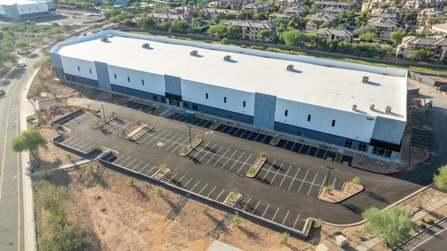
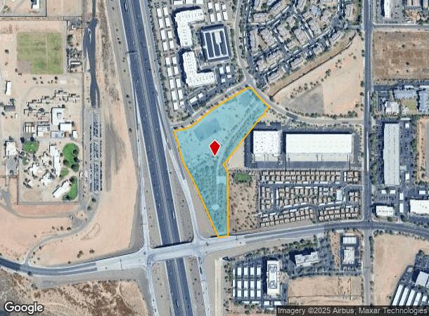
This Property Is For Sale
NEARBY LISTINGS FOR SALE OR LEASE
Property Detail
2415 W Corral Rd
Phoenix
PT W4 SEC 12 DAF COM N4 COR SD SEC 12 TH S 3973.4F TH W 1324.35F TO POB TH S 590.13F TH S 79D-58M W 88.85F TH N 24D-4M W 515.42F TH N 27D-44M W 75.78F TH N 27D-44M W 184.58F TH N 16D-7M W 279.7F TH N 31D-57M E 18.69F TH N 80D-0M E 60.37F TH TAN CUR L
Phoenix-Mesa-Scottsdale, AZ
Maricopa
210-05-943E
Arizona
Stateproperty
11.32 AC
0
Deer Vly/Pinnacle Pk
2025
DEMOGRAPHICS near 2415 W Corral Rd
1 Mile
3 Mile
5 Mile
2024 Total Population
4,919
62,729
178,037
2029 Population
5,545
68,389
192,314
Pop Growth 2024-2029
+ 12.73%
+ 9.02%
+ 8.02%
Average Age
35
37
38
2024 Total Households
2,271
24,485
68,682
HH Growth 2024-2029
+ 13.03%
+ 9.32%
+ 8.14%
Median Household Inc
$81,434
$85,413
$82,805
Avg Household Size
2.20
2.50
2.50
2024 Avg HH Vehicles
1.00
2.00
2.00
Median Home Value
$380,689
$355,064
$352,786
Median Year Built
2008
1996
1991
Nearby Places
Map Layers
Map Styles
 Street
 Aerial
- Restaurants
- Banks
- Shops
- Fitness
- Groceries
PUBLIC TRANSPORTATION
AIRPORT
Phoenix Sky Harbor International
DRIVE
WALK
Distance
Phoenix Sky Harbor International
37 min
25.7 mi
Freight Ports
Port of San Diego
DRIVE
WALK
Distance
Port of San Diego
412 min
368.1 mi
Nearby Properties
Address
Land Use
TOTAL SIZE
Lot Size
Zoning
Address
Land Use
TOTAL SIZE
Lot Size
Zoning
159,642 SF
11.85 AC
C-C
Address
Land Use
TOTAL SIZE
Lot Size
Zoning
132,348 SF
9.16 AC
I-P
Address
Land Use
TOTAL SIZE
Lot Size
Zoning
2,354,235 SF
83.18 AC
CPGCP
Address
Land Use
TOTAL SIZE
Lot Size
Zoning
Address
Land Use
TOTAL SIZE
Lot Size
Zoning
53,813 SF
1,286.11 AC
Address
Land Use
TOTAL SIZE
Lot Size
Zoning
267,397 SF
108.70 AC
R-43AG
Address
Land Use
TOTAL SIZE
Lot Size
Zoning
704,521 SF
15.12 AC
C-C
Address
Land Use
TOTAL SIZE
Lot Size
Zoning
625,318 SF
15.79 AC
Address
Land Use
TOTAL SIZE
Lot Size
Zoning
16.84 AC
Address
Land Use
TOTAL SIZE
Lot Size
Zoning
434,799 SF
69.70 AC
R-8
Address
Land Use
TOTAL SIZE
Lot Size
Zoning
302,786 SF
220.27 AC
S-1
Address
Land Use
TOTAL SIZE
Lot Size
Zoning
355,901 SF
40.61 AC
Address
Land Use
TOTAL SIZE
Lot Size
Zoning
471,671 SF
18.04 AC
I-1
Address
Land Use
TOTAL SIZE
Lot Size
Zoning
389,967 SF
245.48 AC
I-1
Address
Land Use
TOTAL SIZE
Lot Size
Zoning
264,909 SF
219.16 AC
I-1
Address
Land Use
TOTAL SIZE
Lot Size
Zoning
968,899 SF
76.37 AC
I-1
Address
Land Use
TOTAL SIZE
Lot Size
Zoning
425,279 SF
11.64 AC
S1
Address
Land Use
TOTAL SIZE
Lot Size
Zoning
408,519 SF
18.70 AC
PAD
Address
Land Use
TOTAL SIZE
Lot Size
Zoning
361,228 SF
24.60 AC
I-P
Address
Land Use
TOTAL SIZE
Lot Size
Zoning
296,753 SF
9.53 AC
CPBP
Address
Land Use
TOTAL SIZE
Lot Size
Zoning
307,891 SF
15.89 AC
Address
Land Use
TOTAL SIZE
Lot Size
Zoning
28.71 AC
Address
Land Use
TOTAL SIZE
Lot Size
Zoning
312,070 SF
20.04 AC
A1
Address
Land Use
TOTAL SIZE
Lot Size
Zoning
291,059 SF
16.54 AC
I-1
Address
Land Use
TOTAL SIZE
Lot Size
Zoning
228,085 SF
7.84 AC
I-P
Address
Land Use
TOTAL SIZE
Lot Size
Zoning
149,165 SF
12.33 AC
C2
Address
Land Use
TOTAL SIZE
Lot Size
Zoning
266,319 SF
10.28 AC
R3A
Address
Land Use
TOTAL SIZE
Lot Size
Zoning
244,787 SF
5.83 AC
Address
Land Use
TOTAL SIZE
Lot Size
Zoning
15,000 SF
359.72 AC
R-43
Address
Land Use
TOTAL SIZE
Lot Size
Zoning
189,524 SF
13.80 AC
I-P
The World's #1 Commercial Real Estate Marketplace
Connect with us
© 2025 CoStar Group
The information above has been obtained from sources believed reliable. While we do not doubt its accuracy we have not verified it and make no guarantee, warranty or representation about it. It is your responsibility to independently confirm its accuracy and completeness. Any projections, opinions, assumptions, or estimates used are for example only and do not represent the current or future performance of the property. The value of this transaction to you depends on tax and other factors which should be evaluated by your tax, financial, and legal advisors. You and your advisors should conduct a careful, independent investigation of the property to determine to your satisfaction the suitability of the property for your needs.