Property Record
5220 Bradshaw Rd, Sacramento, CA 95829
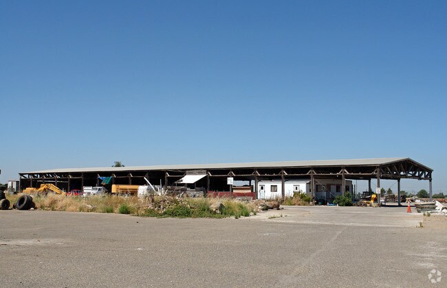

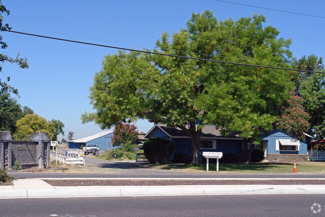
Property Detail
5220 Bradshaw Rd
Sacramento-Roseville-Folsom, CA
POR SEC 20 TWP 8 N R 6 E M D B & M DES AS BEG ATA PT ON E LINE LOT 1 ANDERSON TR LOC S 17% 2150 W 350.12 FT FROM NE COR TH S
063-0070-008
SACRAMENTO
Commercialacreage
California
GC
1
B and X Area of moderate flood hazard, usually the area between the limits of the 100-year and 500-year floods.
7.42 AC
2024
Power Inn
2025
Sacramento
009201
NEARBY LISTINGS FOR SALE OR LEASE
DEMOGRAPHICS near 5220 Bradshaw Rd
1 mile
3 mile
5 mile
2025 Total Population
60
39,311
199,882
2030 Population
57
39,935
202,495
Pop Growth 2025-2030
(5.00%)
+ 1.59%
+ 1.31%
Average Age
41
39
39
2025 Total Households
18
14,207
68,666
HH Growth 2025-2030
(5.56%)
+ 1.58%
+ 1.36%
Median Household Inc
$81,250
$87,713
$90,905
Avg Household Size
3.10
2.70
2.80
2025 Avg HH Vehicles
3.00
2.00
2.00
Median Home Value
$949,999
$474,530
$492,262
Median Year Built
1957
1977
1977
Nearby Places
Map Layers
Map Styles
 Street
 Aerial
Layers
 Traffic
 Biking
Places
Listings with unknown addresses are not visible on the map
- Restaurants
- Banks
- Shops
- Fitness
- Groceries
PUBLIC TRANSPORTATION
AIRPORT
Sacramento International
Drive
Walk
Distance
Sacramento International
31 min
21.9 mi
Freight Ports
Port of Stockton
Drive
Walk
Distance
Port of Stockton
61 min
47.1 mi
Nearby Properties
Address
Land Use
TOTAL SIZE
Lot Size
Zoning
Address
Land Use
TOTAL SIZE
Lot Size
Zoning
149,566 SF
9.68 AC
M-2S
Address
Land Use
TOTAL SIZE
Lot Size
Zoning
266,841 SF
47.29 AC
RD-5
Address
Land Use
TOTAL SIZE
Lot Size
Zoning
584,820 SF
29.12 AC
M-2S
Address
Land Use
TOTAL SIZE
Lot Size
Zoning
139,500 SF
5.21 AC
MP
Address
Land Use
TOTAL SIZE
Lot Size
Zoning
0.21 AC
RD-5
Address
Land Use
TOTAL SIZE
Lot Size
Zoning
135,375 SF
7.40 AC
RD-30
Address
Land Use
TOTAL SIZE
Lot Size
Zoning
198,131 SF
13.36 AC
BP
Address
Land Use
TOTAL SIZE
Lot Size
Zoning
188,144 SF
16.90 AC
M-2S
Address
Land Use
TOTAL SIZE
Lot Size
Zoning
12.04 AC
M-1S-R
Address
Land Use
TOTAL SIZE
Lot Size
Zoning
8,724 SF
101.84 AC
M-2 (SM)
Address
Land Use
TOTAL SIZE
Lot Size
Zoning
203,374 SF
12 AC
RD-20
Address
Land Use
TOTAL SIZE
Lot Size
Zoning
85,131 SF
4.90 AC
RD 20
Address
Land Use
TOTAL SIZE
Lot Size
Zoning
273,000 SF
14.38 AC
M-1S-SWR
Address
Land Use
TOTAL SIZE
Lot Size
Zoning
75,765 SF
19.04 AC
M-1S-R
Address
Land Use
TOTAL SIZE
Lot Size
Zoning
131,744 SF
6.66 AC
BP
Address
Land Use
TOTAL SIZE
Lot Size
Zoning
126,000 SF
8 AC
MP
Address
Land Use
TOTAL SIZE
Lot Size
Zoning
88,000 SF
5.60 AC
MP
Address
Land Use
TOTAL SIZE
Lot Size
Zoning
81,852 SF
4.13 AC
RD-30
Address
Land Use
TOTAL SIZE
Lot Size
Zoning
178,135 SF
1.06 AC
BP
Address
Land Use
TOTAL SIZE
Lot Size
Zoning
800 SF
2.43 AC
M-1 (SM)
Address
Land Use
TOTAL SIZE
Lot Size
Zoning
Address
Land Use
TOTAL SIZE
Lot Size
Zoning
88,500 SF
4.74 AC
MP
Address
Land Use
TOTAL SIZE
Lot Size
Zoning
199,108 SF
11 AC
RD-10
Address
Land Use
TOTAL SIZE
Lot Size
Zoning
216,400 SF
11.68 AC
M-2S
Address
Land Use
TOTAL SIZE
Lot Size
Zoning
240,255 SF
13.67 AC
M-2S
Address
Land Use
TOTAL SIZE
Lot Size
Zoning
1,404 SF
16.14 AC
M-2S
Address
Land Use
TOTAL SIZE
Lot Size
Zoning
53,366 SF
9.07 AC
M-1
Address
Land Use
TOTAL SIZE
Lot Size
Zoning
86,400 SF
4.74 AC
C-2-SPD
Address
Land Use
TOTAL SIZE
Lot Size
Zoning
81,494 SF
4.69 AC
RD 30 RD 2
Address
Land Use
TOTAL SIZE
Lot Size
Zoning
96,658 SF
6.39 AC
M-2S
The World's #1 Commercial Real Estate Marketplace
Connect with us
© 2026 CoStar Group
The information above has been obtained from sources believed reliable. While we do not doubt its accuracy we have not verified it and make no guarantee, warranty or representation about it. It is your responsibility to independently confirm its accuracy and completeness. Any projections, opinions, assumptions, or estimates used are for example only and do not represent the current or future performance of the property. The value of this transaction to you depends on tax and other factors which should be evaluated by your tax, financial, and legal advisors. You and your advisors should conduct a careful, independent investigation of the property to determine to your satisfaction the suitability of the property for your needs.