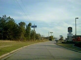
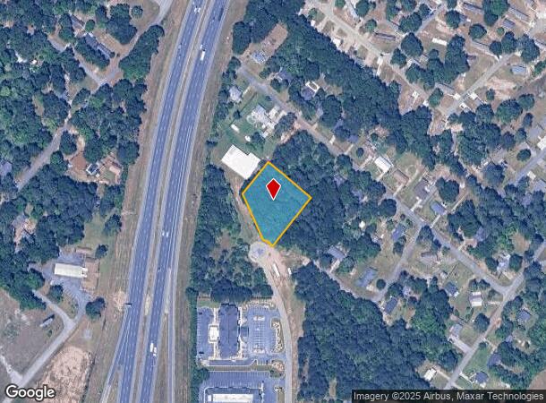
Property Record
Lect Dr, Perry, GA 31069
NEARBY LISTINGS FOR SALE OR LEASE
Property Detail
Lect Dr
Warner Robins, GA
W F Ragin 3.00 Sf
0P0290049000
PT LOT 7 0.974 ACRE LL 315 13TH LD
Commercialacreage
Houston
X
Georgia
13193C0250E
7
2024
0.97 AC
2024
Perry/Warner Robins
021206
Other Market Areas
DEMOGRAPHICS near Lect Dr
1 mile
3 mile
5 mile
2024 Total Population
1,923
13,846
22,618
2029 Population
2,110
15,292
24,984
Pop Growth 2024-2029
+ 9.72%
+ 10.44%
+ 10.46%
Average Age
41
40
39
2024 Total Households
710
5,496
8,729
HH Growth 2024-2029
+ 9.58%
+ 10.28%
+ 10.29%
Median Household Inc
$14,695
$56,290
$67,144
Avg Household Size
2.50
2.40
2.50
2024 Avg HH Vehicles
2.00
2.00
2.00
Median Home Value
$105,426
$158,712
$175,931
Median Year Built
1976
1985
1991
Nearby Places
Map Layers
Map Styles
 Street
 Aerial
Transit
 Traffic
 Biking
Places
Listings with unknown addresses are not visible on the map
- Restaurants
- Banks
- Shops
- Fitness
- Groceries
SALE & LEASE HISTORY
LISTING DATE
SALE/LEASE

Sep 24, 2016
For Sale
Feb 04, 2019
For Sale
Nearby Properties
Address
Land Use
TOTAL SIZE
Lot Size
Zoning
Address
Land Use
TOTAL SIZE
Lot Size
Zoning
68,186 SF
562.30 AC
GU
Address
Land Use
TOTAL SIZE
Lot Size
Zoning
262,500 SF
20 AC
GU
Address
Land Use
TOTAL SIZE
Lot Size
Zoning
528,578 SF
32.75 AC
M2
Address
Land Use
TOTAL SIZE
Lot Size
Zoning
158,300 SF
30 AC
GU
Address
Land Use
TOTAL SIZE
Lot Size
Zoning
120,000 SF
20 AC
M1
Address
Land Use
TOTAL SIZE
Lot Size
Zoning
49,947 SF
4.03 AC
C2
Address
Land Use
TOTAL SIZE
Lot Size
Zoning
78,010 SF
20 AC
C2
Address
Land Use
TOTAL SIZE
Lot Size
Zoning
6,382 SF
24.71 AC
RM-2
Address
Land Use
TOTAL SIZE
Lot Size
Zoning
304,196 SF
177.46 AC
M1
Address
Land Use
TOTAL SIZE
Lot Size
Zoning
25,002 SF
15.17 AC
RM-2
Address
Land Use
TOTAL SIZE
Lot Size
Zoning
442.42 AC
M2
Address
Land Use
TOTAL SIZE
Lot Size
Zoning
151,525 SF
17.55 AC
C2
Address
Land Use
TOTAL SIZE
Lot Size
Zoning
19,125 SF
27.94 AC
R1
Address
Land Use
TOTAL SIZE
Lot Size
Zoning
31,248 SF
10.30 AC
RM-2
Address
Land Use
TOTAL SIZE
Lot Size
Zoning
255.39 AC
GU/M1
Address
Land Use
TOTAL SIZE
Lot Size
Zoning
54,262 SF
38.29 AC
M1
Address
Land Use
TOTAL SIZE
Lot Size
Zoning
4,820 SF
14.59 AC
RM-2
Address
Land Use
TOTAL SIZE
Lot Size
Zoning
12,000 SF
7.27 AC
RM-2
Address
Land Use
TOTAL SIZE
Lot Size
Zoning
226.03 AC
GU
Address
Land Use
TOTAL SIZE
Lot Size
Zoning
134,145 SF
3.08 AC
M2
Address
Land Use
TOTAL SIZE
Lot Size
Zoning
43,486 SF
9.70 AC
FBR
Address
Land Use
TOTAL SIZE
Lot Size
Zoning
134,145 SF
3.08 AC
M2
Address
Land Use
TOTAL SIZE
Lot Size
Zoning
30,050 SF
47.52 AC
GU
Address
Land Use
TOTAL SIZE
Lot Size
Zoning
38,066 SF
11.73 AC
GU
Address
Land Use
TOTAL SIZE
Lot Size
Zoning
44,832 SF
11.95 AC
GU
Address
Land Use
TOTAL SIZE
Lot Size
Zoning
42,908 SF
7.93 AC
C2
Address
Land Use
TOTAL SIZE
Lot Size
Zoning
4,820 SF
14.95 AC
RM-2
Address
Land Use
TOTAL SIZE
Lot Size
Zoning
124.57 AC
M2
Address
Land Use
TOTAL SIZE
Lot Size
Zoning
6,948 SF
10 AC
C2
Address
Land Use
TOTAL SIZE
Lot Size
Zoning
33,970 SF
2.47 AC
C2
The World's #1 Commercial Real Estate Marketplace
Connect with us
© 2026 CoStar Group
The information above has been obtained from sources believed reliable. While we do not doubt its accuracy we have not verified it and make no guarantee, warranty or representation about it. It is your responsibility to independently confirm its accuracy and completeness. Any projections, opinions, assumptions, or estimates used are for example only and do not represent the current or future performance of the property. The value of this transaction to you depends on tax and other factors which should be evaluated by your tax, financial, and legal advisors. You and your advisors should conduct a careful, independent investigation of the property to determine to your satisfaction the suitability of the property for your needs.