Property Record
Lifecore Dr, Fishersville, VA 22939

Property Detail
Lifecore Dr
067-97
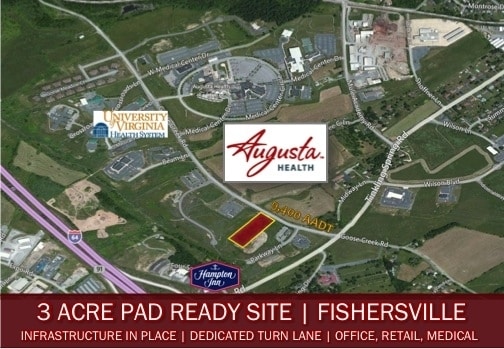
67-97 LOT NEAR TINKLING SPRINGS CH 2.984 AC
Medicalbuilding
AUGUSTA
GENERAL BU
Virginia
B and X Area of moderate flood hazard, usually the area between the limits of the 100-year and 500-year floods.
2.95 AC
2026
Staunton & Harrisonburg
2026
Other Market Areas
070603
Staunton-Stuarts Draft, VA
5,225 SF
NEARBY LISTINGS FOR SALE OR LEASE
DEMOGRAPHICS near Lifecore Dr
1 mile
3 mile
5 mile
2025 Total Population
1,645
13,942
34,842
2030 Population
1,718
14,247
35,865
Pop Growth 2025-2030
+ 4.44%
+ 2.19%
+ 2.94%
Average Age
44
43
44
2025 Total Households
682
5,515
14,581
HH Growth 2025-2030
+ 4.69%
+ 2.39%
+ 3.09%
Median Household Inc
$49,999
$69,595
$63,951
Avg Household Size
2.30
2.40
2.30
2025 Avg HH Vehicles
2.00
2.00
2.00
Median Home Value
$270,426
$330,210
$310,676
Median Year Built
2002
1996
1990
Nearby Places
Map Layers
Map Styles
 Street
 Aerial
Layers
 Traffic
 Biking
Places
Listings with unknown addresses are not visible on the map
- Restaurants
- Banks
- Shops
- Fitness
- Groceries
PUBLIC TRANSPORTATION
COMMUTER RAIL
Drive
Walk
Distance
12 min
7.1 mi
AIRPORT
Charlottesville-Albemarle
Drive
Walk
Distance
Charlottesville-Albemarle
53 min
39.4 mi
Nearby Properties
Address
Land Use
TOTAL SIZE
Lot Size
Zoning
Address
Land Use
TOTAL SIZE
Lot Size
Zoning
35,328 SF
100.10 AC
GENERAL IN
Address
Land Use
TOTAL SIZE
Lot Size
Zoning
422,707 SF
53.88 AC
GENERAL BU
Address
Land Use
TOTAL SIZE
Lot Size
Zoning
103,815 SF
144.63 AC
GENERAL AG
Address
Land Use
TOTAL SIZE
Lot Size
Zoning
17,442 SF
22.14 AC
MULTI-FAMI
Address
Land Use
TOTAL SIZE
Lot Size
Zoning
17,442 SF
7.16 AC
MULTI-FAMI
Address
Land Use
TOTAL SIZE
Lot Size
Zoning
89,506 SF
5.02 AC
GENERAL BU
Address
Land Use
TOTAL SIZE
Lot Size
Zoning
98,326 SF
14.62 AC
GENERAL AG
Address
Land Use
TOTAL SIZE
Lot Size
Zoning
55,056 SF
40 AC
MULTI-FAMI
Address
Land Use
TOTAL SIZE
Lot Size
Zoning
71,141 SF
21.91 AC
GENERAL BU
Address
Land Use
TOTAL SIZE
Lot Size
Zoning
58,660 SF
6.50 AC
GENERAL BU
Address
Land Use
TOTAL SIZE
Lot Size
Zoning
138,341 SF
18.94 AC
H-B
Address
Land Use
TOTAL SIZE
Lot Size
Zoning
15,304 SF
13.39 AC
RS-12
Address
Land Use
TOTAL SIZE
Lot Size
Zoning
56,516 SF
8.29 AC
GENERAL BU
Address
Land Use
TOTAL SIZE
Lot Size
Zoning
39,748 SF
28.84 AC
GENERAL BU
Address
Land Use
TOTAL SIZE
Lot Size
Zoning
46,170 SF
7.83 AC
GENERAL BU
Address
Land Use
TOTAL SIZE
Lot Size
Zoning
34,543 SF
5.01 AC
GENERAL BU
Address
Land Use
TOTAL SIZE
Lot Size
Zoning
44,378 SF
156.80 AC
GENERAL BU
Address
Land Use
TOTAL SIZE
Lot Size
Zoning
48,725 SF
9.21 AC
GENERAL BU
Address
Land Use
TOTAL SIZE
Lot Size
Zoning
54,400 SF
9.33 AC
H-B
Address
Land Use
TOTAL SIZE
Lot Size
Zoning
55,919 SF
3.73 AC
H-B
Address
Land Use
TOTAL SIZE
Lot Size
Zoning
23,826 SF
4.56 AC
GENERAL BU
Address
Land Use
TOTAL SIZE
Lot Size
Zoning
41,913 SF
9.73 AC
PLANNED UN
Address
Land Use
TOTAL SIZE
Lot Size
Zoning
29,520 SF
33.28 AC
GENERAL IN
Address
Land Use
TOTAL SIZE
Lot Size
Zoning
42,343 SF
2.53 AC
GENERAL BU
Address
Land Use
TOTAL SIZE
Lot Size
Zoning
10,704 SF
11 AC
MULTI-FAMI
Address
Land Use
TOTAL SIZE
Lot Size
Zoning
58,706 SF
8.44 AC
GENERAL BU
Address
Land Use
TOTAL SIZE
Lot Size
Zoning
37,080 SF
12 AC
MULTI-FAMI
Address
Land Use
TOTAL SIZE
Lot Size
Zoning
47.54 AC
MANUFACTUR
Address
Land Use
TOTAL SIZE
Lot Size
Zoning
13,994 SF
4.63 AC
MULTI-FAMI
Address
Land Use
TOTAL SIZE
Lot Size
Zoning
30,844 SF
4.72 AC
H-B
The World's #1 Commercial Real Estate Marketplace
Connect with us
© 2026 CoStar Group
The information above has been obtained from sources believed reliable. While we do not doubt its accuracy we have not verified it and make no guarantee, warranty or representation about it. It is your responsibility to independently confirm its accuracy and completeness. Any projections, opinions, assumptions, or estimates used are for example only and do not represent the current or future performance of the property. The value of this transaction to you depends on tax and other factors which should be evaluated by your tax, financial, and legal advisors. You and your advisors should conduct a careful, independent investigation of the property to determine to your satisfaction the suitability of the property for your needs.