Property Record
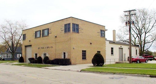
Mason Ave, Aurora, IL 60506
Property Detail
Mason Ave
Chicago-Naperville-Elgin, IL-IN
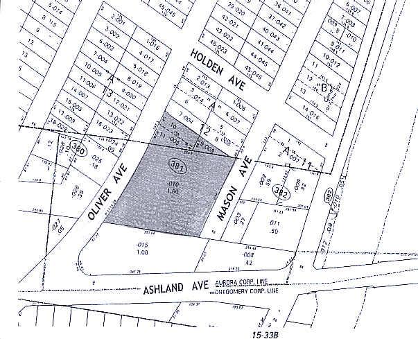
SOUTH END ADDN : LOTS 9, 10 & 11 BLK 12 LOT DIMENSIONS: 78.5 IRREG APPROX LOT SQ FT 79 SUBDIVISION: SOUTH END ADDN RANGE CODE: 001
15-28-381-009
KANE
Industrialgeneral
Illinois
B and X Area of moderate flood hazard, usually the area between the limits of the 100-year and 500-year floods.
9-11
2024
0.15 AC
2024
I-88 West
854002
Chicago
NEARBY LISTINGS FOR SALE OR LEASE
DEMOGRAPHICS near Mason Ave
1 mile
3 mile
5 mile
2025 Total Population
10,122
111,242
228,870
2030 Population
10,220
112,847
234,428
Pop Growth 2025-2030
+ 0.97%
+ 1.44%
+ 2.43%
Average Age
37
37
37
2025 Total Households
3,219
36,226
76,081
HH Growth 2025-2030
+ 0.99%
+ 1.59%
+ 2.47%
Median Household Inc
$70,953
$74,035
$90,208
Avg Household Size
3.00
2.90
2.90
2025 Avg HH Vehicles
2.00
2.00
2.00
Median Home Value
$223,981
$240,755
$271,729
Median Year Built
1955
1966
1985
Nearby Places
Map Layers
Map Styles
 Street
 Aerial
Layers
 Traffic
 Biking
Places
Listings with unknown addresses are not visible on the map
- Restaurants
- Banks
- Shops
- Fitness
- Groceries
PUBLIC TRANSPORTATION
COMMUTER RAIL
Aurora Station (Burlington Northern-Santa Fe Railway Line - Northeast Illinois Regional Commuter Railroad (Metra))
Drive
Walk
Distance
Aurora Station (Burlington Northern-Santa Fe Railway Line - Northeast Illinois Regional Commuter Railroad (Metra))
6 min
2.2 mi
Route 59 Station (Burlington Northern-Santa Fe Railway Line - Northeast Illinois Regional Commuter Railroad (Metra))
Drive
Walk
Distance
Route 59 Station (Burlington Northern-Santa Fe Railway Line - Northeast Illinois Regional Commuter Railroad (Metra))
18 min
9.1 mi
AIRPORT
Chicago O'Hare International
Drive
Walk
Distance
Chicago O'Hare International
59 min
40.1 mi
Freight Ports
Port Milwaukee
Drive
Walk
Distance
Port Milwaukee
140 min
111.8 mi
Nearby Properties
Address
Land Use
TOTAL SIZE
Lot Size
Zoning
Address
Land Use
TOTAL SIZE
Lot Size
Zoning
272,948 SF
16.10 AC
Address
Land Use
TOTAL SIZE
Lot Size
Zoning
19.80 AC
Address
Land Use
TOTAL SIZE
Lot Size
Zoning
296,502 SF
19.01 AC
Address
Land Use
TOTAL SIZE
Lot Size
Zoning
350.78 AC
Address
Land Use
TOTAL SIZE
Lot Size
Zoning
320,874 SF
1.49 AC
Address
Land Use
TOTAL SIZE
Lot Size
Zoning
989,724 SF
49.41 AC
Address
Land Use
TOTAL SIZE
Lot Size
Zoning
56.02 AC
Address
Land Use
TOTAL SIZE
Lot Size
Zoning
169,918 SF
20 AC
Address
Land Use
TOTAL SIZE
Lot Size
Zoning
100,340 SF
1.80 AC
Address
Land Use
TOTAL SIZE
Lot Size
Zoning
428,544 SF
41.38 AC
Address
Land Use
TOTAL SIZE
Lot Size
Zoning
73,880 SF
0.75 AC
Address
Land Use
TOTAL SIZE
Lot Size
Zoning
218,020 SF
21.35 AC
Address
Land Use
TOTAL SIZE
Lot Size
Zoning
97,136 SF
6.08 AC
Address
Land Use
TOTAL SIZE
Lot Size
Zoning
220,091 SF
22.09 AC
Address
Land Use
TOTAL SIZE
Lot Size
Zoning
9.86 AC
Address
Land Use
TOTAL SIZE
Lot Size
Zoning
207,596 SF
20.63 AC
Address
Land Use
TOTAL SIZE
Lot Size
Zoning
259,140 SF
18.05 AC
Address
Land Use
TOTAL SIZE
Lot Size
Zoning
366,503 SF
11.88 AC
Address
Land Use
TOTAL SIZE
Lot Size
Zoning
140,888 SF
16.31 AC
Address
Land Use
TOTAL SIZE
Lot Size
Zoning
56.13 AC
Address
Land Use
TOTAL SIZE
Lot Size
Zoning
51,375 SF
8.73 AC
Address
Land Use
TOTAL SIZE
Lot Size
Zoning
136,900 SF
3.63 AC
Address
Land Use
TOTAL SIZE
Lot Size
Zoning
82,150 SF
23.67 AC
Address
Land Use
TOTAL SIZE
Lot Size
Zoning
217,505 SF
17.50 AC
Address
Land Use
TOTAL SIZE
Lot Size
Zoning
581,048 SF
37.29 AC
Address
Land Use
TOTAL SIZE
Lot Size
Zoning
3.85 AC
Address
Land Use
TOTAL SIZE
Lot Size
Zoning
70,780 SF
10.91 AC
Address
Land Use
TOTAL SIZE
Lot Size
Zoning
201,713 SF
16.55 AC
The World's #1 Commercial Real Estate Marketplace
Connect with us
© 2026 CoStar Group
The information above has been obtained from sources believed reliable. While we do not doubt its accuracy we have not verified it and make no guarantee, warranty or representation about it. It is your responsibility to independently confirm its accuracy and completeness. Any projections, opinions, assumptions, or estimates used are for example only and do not represent the current or future performance of the property. The value of this transaction to you depends on tax and other factors which should be evaluated by your tax, financial, and legal advisors. You and your advisors should conduct a careful, independent investigation of the property to determine to your satisfaction the suitability of the property for your needs.