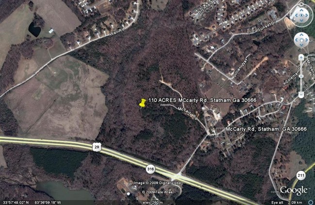
Property Record
Mccarty Rd, Statham, GA 30666

Save to a Folder
{{folder.Name}}
{{folder.ListingIds.length}} Properties
{{folder.ListingIds.length}} Property
Create a New Folder
Property Detail
Mccarty Rd
ST02-011
BARROW
Residentialacreage
Georgia
PUD
109.58 AC
B and X Area of moderate flood hazard, usually the area between the limits of the 100-year and 500-year floods.
Barrow County
2025
Atlanta
2025
Atlanta-Sandy Springs-Roswell, GA
180402
NEARBY LISTINGS FOR SALE OR LEASE
DEMOGRAPHICS near Mccarty Rd
1 mile
3 mile
5 mile
2025 Total Population
1,523
12,925
30,718
2030 Population
1,727
14,638
34,490
Pop Growth 2025-2030
+ 13.39%
+ 13.25%
+ 12.28%
Average Age
40
39
38
2025 Total Households
545
4,559
10,576
HH Growth 2025-2030
+ 13.58%
+ 13.40%
+ 12.43%
Median Household Inc
$63,587
$74,262
$79,031
Avg Household Size
2.80
2.80
2.90
2025 Avg HH Vehicles
2.00
2.00
2.00
Median Home Value
$284,926
$301,957
$301,959
Median Year Built
2000
2004
2004
Nearby Places
Map Layers
Map Styles
 Street
 Aerial
Layers
 Traffic
 Biking
Places
Listings with unknown addresses are not visible on the map
- Restaurants
- Banks
- Shops
- Fitness
- Groceries
Nearby Properties
Address
Land Use
TOTAL SIZE
Lot Size
Zoning
Address
Land Use
TOTAL SIZE
Lot Size
Zoning
398,490 SF
56.68 AC
M-1
Address
Land Use
TOTAL SIZE
Lot Size
Zoning
275,840 SF
22.10 AC
M-1
Address
Land Use
TOTAL SIZE
Lot Size
Zoning
66,052 SF
30.25 AC
AG
Address
Land Use
TOTAL SIZE
Lot Size
Zoning
85,000 SF
85.91 AC
AC
Address
Land Use
TOTAL SIZE
Lot Size
Zoning
160,000 SF
29.44 AC
O-I
Address
Land Use
TOTAL SIZE
Lot Size
Zoning
27,337 SF
60 AC
M-2
Address
Land Use
TOTAL SIZE
Lot Size
Zoning
30,056 SF
311.73 AC
R-2
Address
Land Use
TOTAL SIZE
Lot Size
Zoning
224,093 SF
17.12 AC
LI
Address
Land Use
TOTAL SIZE
Lot Size
Zoning
85,290 SF
29.13 AC
C-3
Address
Land Use
TOTAL SIZE
Lot Size
Zoning
33,704 SF
14.25 AC
O-I
Address
Land Use
TOTAL SIZE
Lot Size
Zoning
67,000 SF
20 AC
AC
Address
Land Use
TOTAL SIZE
Lot Size
Zoning
41,916 SF
16.11 AC
LI
Address
Land Use
TOTAL SIZE
Lot Size
Zoning
2,800 SF
5.32 AC
O-I
Address
Land Use
TOTAL SIZE
Lot Size
Zoning
25,044 SF
9.01 AC
M-1
Address
Land Use
TOTAL SIZE
Lot Size
Zoning
10,125 SF
63.63 AC
M-2
Address
Land Use
TOTAL SIZE
Lot Size
Zoning
24,222 SF
3.81 AC
O-I
Address
Land Use
TOTAL SIZE
Lot Size
Zoning
20,891 SF
3.10 AC
HB
Address
Land Use
TOTAL SIZE
Lot Size
Zoning
1,421 SF
6.09 AC
R-2
Address
Land Use
TOTAL SIZE
Lot Size
Zoning
7,500 SF
3 AC
LI
Address
Land Use
TOTAL SIZE
Lot Size
Zoning
5,343 SF
0.32 AC
R-1-MPD
Address
Land Use
TOTAL SIZE
Lot Size
Zoning
2,350 SF
238.88 AC
M-1
Address
Land Use
TOTAL SIZE
Lot Size
Zoning
984 SF
2.07 AC
HB
Address
Land Use
TOTAL SIZE
Lot Size
Zoning
26,400 SF
13.38 AC
M-1
Address
Land Use
TOTAL SIZE
Lot Size
Zoning
64,733 SF
1.58 AC
CB
Address
Land Use
TOTAL SIZE
Lot Size
Zoning
3,200 SF
3.43 AC
M-1
Address
Land Use
TOTAL SIZE
Lot Size
Zoning
18,865 SF
0.46 AC
HR
Address
Land Use
TOTAL SIZE
Lot Size
Zoning
84.74 AC
AG
Address
Land Use
TOTAL SIZE
Lot Size
Zoning
10,000 SF
2.57 AC
LI
Address
Land Use
TOTAL SIZE
Lot Size
Zoning
50.42 AC
AG
Address
Land Use
TOTAL SIZE
Lot Size
Zoning
86.11 AC
LI/HB
The World's #1 Commercial Real Estate Marketplace
Connect with us
© 2026 CoStar Group
The information above has been obtained from sources believed reliable. While we do not doubt its accuracy we have not verified it and make no guarantee, warranty or representation about it. It is your responsibility to independently confirm its accuracy and completeness. Any projections, opinions, assumptions, or estimates used are for example only and do not represent the current or future performance of the property. The value of this transaction to you depends on tax and other factors which should be evaluated by your tax, financial, and legal advisors. You and your advisors should conduct a careful, independent investigation of the property to determine to your satisfaction the suitability of the property for your needs.