Property Record
Mousette Ln, Cahokia, IL 62206
Save to a Folder
{{folder.Name}}
{{folder.ListingIds.length}} Properties
{{folder.ListingIds.length}} Property
Create a New Folder
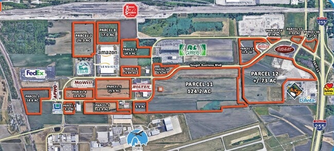
This Property Is For Sale
Property Detail
Mousette Ln
St. Louis, MO-IL
ST LOUIS DOWNTOWN AIRPORT BUSINESS PARK LOT/SEC-9 EXC PT FOR RD IN BK 2805-605
07-06.0-200-022
ST. CLAIR
Agriculturalland
Illinois
2024
2.11 AC
2024
Illinois
502603
St. Louis
NEARBY LISTINGS FOR SALE OR LEASE
DEMOGRAPHICS near Mousette Ln
1 mile
3 mile
5 mile
2025 Total Population
573
27,998
80,617
2030 Population
567
28,410
80,172
Pop Growth 2025-2030
(1.05%)
+ 1.47%
(0.55%)
Average Age
36
39
39
2025 Total Households
237
10,825
35,267
HH Growth 2025-2030
(1.27%)
+ 1.56%
(1.03%)
Median Household Inc
$37,941
$34,999
$47,504
Avg Household Size
2.40
2.50
2.20
2025 Avg HH Vehicles
1.00
1.00
1.00
Median Home Value
$62,337
$59,422
$93,102
Median Year Built
1966
1965
1956
Nearby Places
Map Layers
Map Styles
 Street
 Aerial
Layers
 Traffic
 Biking
Places
Listings with unknown addresses are not visible on the map
- Restaurants
- Banks
- Shops
- Fitness
- Groceries
PUBLIC TRANSPORTATION
COMMUTER RAIL
Washington Park (Lambert Airport Shiloh-Scott - St. Louis MetroLink (MetroLink), Shrewsbury-Lansdowne I-44 Emerson Park - St. Louis MetroLink (MetroLink))
Drive
Walk
Distance
Washington Park (Lambert Airport Shiloh-Scott - St. Louis MetroLink (MetroLink), Shrewsbury-Lansdowne I-44 Emerson Park - St. Louis MetroLink (MetroLink))
8 min
5.4 mi
Jackie Joyner-Kersee (Lambert Airport Shiloh-Scott - St. Louis MetroLink (MetroLink), Shrewsbury-Lansdowne I-44 Emerson Park - St. Louis MetroLink (MetroLink))
Drive
Walk
Distance
Jackie Joyner-Kersee (Lambert Airport Shiloh-Scott - St. Louis MetroLink (MetroLink), Shrewsbury-Lansdowne I-44 Emerson Park - St. Louis MetroLink (MetroLink))
10 min
6.1 mi
AIRPORT
St Louis Lambert International
Drive
Walk
Distance
St Louis Lambert International
33 min
22.1 mi
Scott AFB/Midamerica St Louis
Drive
Walk
Distance
Scott AFB/Midamerica St Louis
35 min
22.8 mi
Freight Ports
Port Milwaukee
Drive
Walk
Distance
Port Milwaukee
416 min
368.9 mi
Nearby Properties
Address
Land Use
TOTAL SIZE
Lot Size
Zoning
Address
Land Use
TOTAL SIZE
Lot Size
Zoning
12,308 SF
18.44 AC
Address
Land Use
TOTAL SIZE
Lot Size
Zoning
Address
Land Use
TOTAL SIZE
Lot Size
Zoning
Address
Land Use
TOTAL SIZE
Lot Size
Zoning
147,888 SF
52.30 AC
Address
Land Use
TOTAL SIZE
Lot Size
Zoning
197,690 SF
32.20 AC
Address
Land Use
TOTAL SIZE
Lot Size
Zoning
118,030 SF
6.78 AC
Address
Land Use
TOTAL SIZE
Lot Size
Zoning
80,000 SF
71.47 AC
Address
Land Use
TOTAL SIZE
Lot Size
Zoning
15,323 SF
10.38 AC
Address
Land Use
TOTAL SIZE
Lot Size
Zoning
Address
Land Use
TOTAL SIZE
Lot Size
Zoning
16,958 SF
24.53 AC
Address
Land Use
TOTAL SIZE
Lot Size
Zoning
Address
Land Use
TOTAL SIZE
Lot Size
Zoning
18.43 AC
Address
Land Use
TOTAL SIZE
Lot Size
Zoning
26.26 AC
C2
Address
Land Use
TOTAL SIZE
Lot Size
Zoning
8,745 SF
14.55 AC
Address
Land Use
TOTAL SIZE
Lot Size
Zoning
61,580 SF
16.32 AC
Address
Land Use
TOTAL SIZE
Lot Size
Zoning
Address
Land Use
TOTAL SIZE
Lot Size
Zoning
4,638 SF
13.10 AC
Address
Land Use
TOTAL SIZE
Lot Size
Zoning
Address
Land Use
TOTAL SIZE
Lot Size
Zoning
12,354 SF
52.25 AC
Address
Land Use
TOTAL SIZE
Lot Size
Zoning
51,739 SF
1.99 AC
Address
Land Use
TOTAL SIZE
Lot Size
Zoning
16,637 SF
4.59 AC
Address
Land Use
TOTAL SIZE
Lot Size
Zoning
Address
Land Use
TOTAL SIZE
Lot Size
Zoning
19.66 AC
Address
Land Use
TOTAL SIZE
Lot Size
Zoning
67,386 SF
7.60 AC
Address
Land Use
TOTAL SIZE
Lot Size
Zoning
44,330 SF
5.66 AC
Address
Land Use
TOTAL SIZE
Lot Size
Zoning
14.70 AC
Address
Land Use
TOTAL SIZE
Lot Size
Zoning
67,524 SF
6.11 AC
Address
Land Use
TOTAL SIZE
Lot Size
Zoning
20,924 SF
6.16 AC
Address
Land Use
TOTAL SIZE
Lot Size
Zoning
37,368 SF
3.81 AC
Address
Land Use
TOTAL SIZE
Lot Size
Zoning
71,600 SF
32.19 AC
The World's #1 Commercial Real Estate Marketplace
Connect with us
© 2026 CoStar Group
The information above has been obtained from sources believed reliable. While we do not doubt its accuracy we have not verified it and make no guarantee, warranty or representation about it. It is your responsibility to independently confirm its accuracy and completeness. Any projections, opinions, assumptions, or estimates used are for example only and do not represent the current or future performance of the property. The value of this transaction to you depends on tax and other factors which should be evaluated by your tax, financial, and legal advisors. You and your advisors should conduct a careful, independent investigation of the property to determine to your satisfaction the suitability of the property for your needs.