Property Record
N Highway 83, Forsyth, GA 31029

Save to a Folder
{{folder.Name}}
{{folder.ListingIds.length}} Properties
{{folder.ListingIds.length}} Property
Create a New Folder
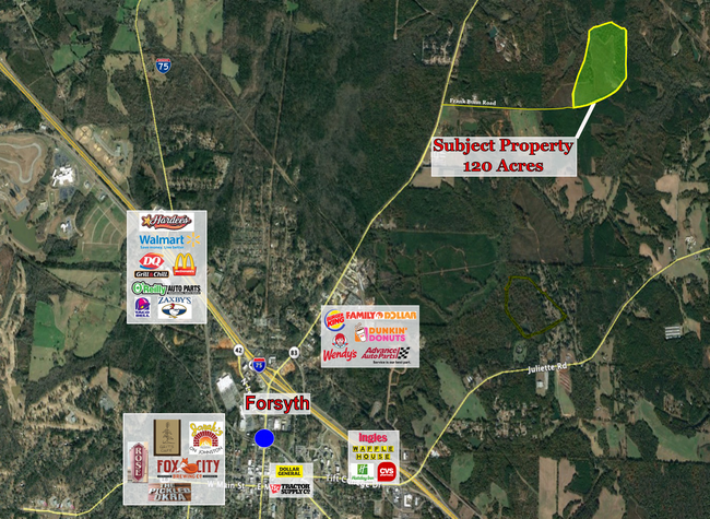
Property Detail
N Highway 83
Macon-Bibb County, GA
LL 230,231 LD 6
064-012A
MONROE
Privatepreserveopenspacevacantlandforestlandconservation
Georgia
A Areas with a 1% annual chance of flooding and a 26% chance of flooding over the life of a 30-year mortgage.
120 AC
2025
Monroe County
2025
Atlanta
050102
NEARBY LISTINGS FOR SALE OR LEASE
DEMOGRAPHICS near N Highway 83
1 mile
3 mile
5 mile
2025 Total Population
88
3,846
10,753
2030 Population
97
4,251
11,919
Pop Growth 2025-2030
+ 10.23%
+ 10.53%
+ 10.84%
Average Age
41
40
41
2025 Total Households
33
1,444
4,079
HH Growth 2025-2030
+ 12.12%
+ 10.87%
+ 11.23%
Median Household Inc
$77,500
$75,326
$76,378
Avg Household Size
2.50
2.60
2.50
2025 Avg HH Vehicles
2.00
2.00
2.00
Median Home Value
$287,499
$249,696
$243,528
Median Year Built
1985
1986
1983
Nearby Places
Map Layers
Map Styles
 Street
 Aerial
Layers
 Traffic
 Biking
Places
Listings with unknown addresses are not visible on the map
- Restaurants
- Banks
- Shops
- Fitness
- Groceries
SALE & LEASE HISTORY
LISTING DATE
SALE/LEASE

Sep 17, 2020
For Sale
Nearby Properties
Address
Land Use
TOTAL SIZE
Lot Size
Zoning
Address
Land Use
TOTAL SIZE
Lot Size
Zoning
30.77 AC
002
Address
Land Use
TOTAL SIZE
Lot Size
Zoning
0.11 AC
007
Address
Land Use
TOTAL SIZE
Lot Size
Zoning
47,072 SF
2.89 AC
003
Address
Land Use
TOTAL SIZE
Lot Size
Zoning
55,261 SF
17.91 AC
006
Address
Land Use
TOTAL SIZE
Lot Size
Zoning
12,960 SF
2.70 AC
001
Address
Land Use
TOTAL SIZE
Lot Size
Zoning
2,464 SF
10.70 AC
006
Address
Land Use
TOTAL SIZE
Lot Size
Zoning
3.02 AC
006
Address
Land Use
TOTAL SIZE
Lot Size
Zoning
50,820 SF
2.43 AC
006
Address
Land Use
TOTAL SIZE
Lot Size
Zoning
15,628 SF
5.56 AC
001
Address
Land Use
TOTAL SIZE
Lot Size
Zoning
76.10 AC
Address
Land Use
TOTAL SIZE
Lot Size
Zoning
1,382.47 AC
005
Address
Land Use
TOTAL SIZE
Lot Size
Zoning
27,125 SF
5.25 AC
006
Address
Land Use
TOTAL SIZE
Lot Size
Zoning
5,276 SF
1.78 AC
Address
Land Use
TOTAL SIZE
Lot Size
Zoning
27.81 AC
Address
Land Use
TOTAL SIZE
Lot Size
Zoning
22.37 AC
006
Address
Land Use
TOTAL SIZE
Lot Size
Zoning
9,000 SF
0.61 AC
003
Address
Land Use
TOTAL SIZE
Lot Size
Zoning
4,240 SF
1.33 AC
003
Address
Land Use
TOTAL SIZE
Lot Size
Zoning
25,296 SF
2.49 AC
Address
Land Use
TOTAL SIZE
Lot Size
Zoning
11,976 SF
0.80 AC
001
Address
Land Use
TOTAL SIZE
Lot Size
Zoning
3,600 SF
1.08 AC
Address
Land Use
TOTAL SIZE
Lot Size
Zoning
19,343 SF
5.40 AC
006
Address
Land Use
TOTAL SIZE
Lot Size
Zoning
23,040 SF
4.21 AC
001
Address
Land Use
TOTAL SIZE
Lot Size
Zoning
22.64 AC
Address
Land Use
TOTAL SIZE
Lot Size
Zoning
1,438 SF
2.30 AC
001
Address
Land Use
TOTAL SIZE
Lot Size
Zoning
9,613 SF
4.21 AC
001
Address
Land Use
TOTAL SIZE
Lot Size
Zoning
532.94 AC
005
Address
Land Use
TOTAL SIZE
Lot Size
Zoning
6,737 SF
5 AC
Address
Land Use
TOTAL SIZE
Lot Size
Zoning
16,096 SF
6.03 AC
001
Address
Land Use
TOTAL SIZE
Lot Size
Zoning
578 AC
005
Address
Land Use
TOTAL SIZE
Lot Size
Zoning
8,400 SF
3.60 AC
002
The World's #1 Commercial Real Estate Marketplace
Connect with us
© 2026 CoStar Group
The information above has been obtained from sources believed reliable. While we do not doubt its accuracy we have not verified it and make no guarantee, warranty or representation about it. It is your responsibility to independently confirm its accuracy and completeness. Any projections, opinions, assumptions, or estimates used are for example only and do not represent the current or future performance of the property. The value of this transaction to you depends on tax and other factors which should be evaluated by your tax, financial, and legal advisors. You and your advisors should conduct a careful, independent investigation of the property to determine to your satisfaction the suitability of the property for your needs.