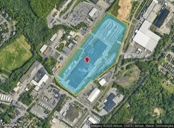
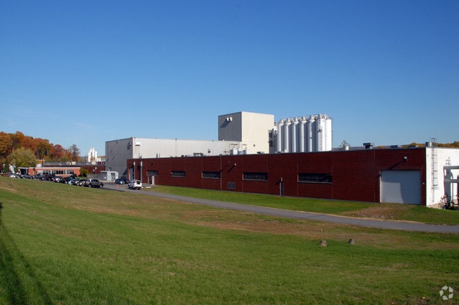
Property Record
N Keyser Ave At North South Rd, Scranton, PA 18504

NEARBY LISTINGS FOR SALE OR LEASE
Property Detail
N Keyser Ave At North South Rd
13417030001
27.28A BLDG & LAND W-21 B-0160 L-0000 P-00700
Industrialgeneral
Lackawanna
AE
Pennsylvania
42069C0212D
27.28 AC
2025
I-81 Corridor
2025
Philadelphia
102000
Scranton--Wilkes-Barre--Hazelton, PA
DEMOGRAPHICS near N Keyser Ave At North South Rd
1 Mile
3 Mile
5 Mile
2024 Total Population
7,401
74,651
128,260
2029 Population
7,288
74,238
127,091
Pop Growth 2024-2029
(1.53%)
(0.55%)
(0.91%)
Average Age
42
40
41
2024 Total Households
3,099
29,435
52,228
HH Growth 2024-2029
(1.58%)
(0.56%)
(0.93%)
Median Household Inc
$61,338
$48,799
$57,945
Avg Household Size
2.30
2.20
2.30
2024 Avg HH Vehicles
2.00
1.00
2.00
Median Home Value
$133,766
$132,671
$157,500
Median Year Built
1947
1947
1949
Nearby Places
Map Layers
Map Styles
 Street
 Aerial
- Restaurants
- Banks
- Shops
- Fitness
- Groceries
PUBLIC TRANSPORTATION
AIRPORT
Wilkes-Barre/Scranton International
DRIVE
WALK
Distance
Wilkes-Barre/Scranton International
20 min
11.4 mi
Freight Ports
Maher Terminal
DRIVE
WALK
Distance
Maher Terminal
148 min
117.9 mi
Nearby Properties
Address
Land Use
TOTAL SIZE
Lot Size
Zoning
Address
Land Use
TOTAL SIZE
Lot Size
Zoning
2.62 AC
Address
Land Use
TOTAL SIZE
Lot Size
Zoning
Address
Land Use
TOTAL SIZE
Lot Size
Zoning
Address
Land Use
TOTAL SIZE
Lot Size
Zoning
2.30 AC
Address
Land Use
TOTAL SIZE
Lot Size
Zoning
4.20 AC
Address
Land Use
TOTAL SIZE
Lot Size
Zoning
15.50 AC
Address
Land Use
TOTAL SIZE
Lot Size
Zoning
3.86 AC
Address
Land Use
TOTAL SIZE
Lot Size
Zoning
0.99 AC
Address
Land Use
TOTAL SIZE
Lot Size
Zoning
12.88 AC
Address
Land Use
TOTAL SIZE
Lot Size
Zoning
Address
Land Use
TOTAL SIZE
Lot Size
Zoning
43.52 AC
Address
Land Use
TOTAL SIZE
Lot Size
Zoning
Address
Land Use
TOTAL SIZE
Lot Size
Zoning
4.85 AC
Address
Land Use
TOTAL SIZE
Lot Size
Zoning
Address
Land Use
TOTAL SIZE
Lot Size
Zoning
Address
Land Use
TOTAL SIZE
Lot Size
Zoning
2.65 AC
Address
Land Use
TOTAL SIZE
Lot Size
Zoning
0.27 AC
Address
Land Use
TOTAL SIZE
Lot Size
Zoning
97.16 AC
Address
Land Use
TOTAL SIZE
Lot Size
Zoning
Address
Land Use
TOTAL SIZE
Lot Size
Zoning
5.35 AC
Address
Land Use
TOTAL SIZE
Lot Size
Zoning
Address
Land Use
TOTAL SIZE
Lot Size
Zoning
3.86 AC
Address
Land Use
TOTAL SIZE
Lot Size
Zoning
Address
Land Use
TOTAL SIZE
Lot Size
Zoning
Address
Land Use
TOTAL SIZE
Lot Size
Zoning
3.11 AC
Address
Land Use
TOTAL SIZE
Lot Size
Zoning
9.55 AC
Address
Land Use
TOTAL SIZE
Lot Size
Zoning
Address
Land Use
TOTAL SIZE
Lot Size
Zoning
Address
Land Use
TOTAL SIZE
Lot Size
Zoning
Address
Land Use
TOTAL SIZE
Lot Size
Zoning
34.57 AC
The World's #1 Commercial Real Estate Marketplace
Connect with us
© 2025 CoStar Group
The information above has been obtained from sources believed reliable. While we do not doubt its accuracy we have not verified it and make no guarantee, warranty or representation about it. It is your responsibility to independently confirm its accuracy and completeness. Any projections, opinions, assumptions, or estimates used are for example only and do not represent the current or future performance of the property. The value of this transaction to you depends on tax and other factors which should be evaluated by your tax, financial, and legal advisors. You and your advisors should conduct a careful, independent investigation of the property to determine to your satisfaction the suitability of the property for your needs.