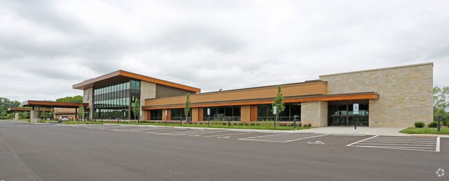
Property Record
N15w28300 Golf Rd, Pewaukee, WI 53072


NEARBY LISTINGS FOR SALE OR LEASE
Property Detail
N15w28300 Golf Rd
Milwaukee-Waukesha, WI
Access Easement
DELT-0813-983-005
LOT 2 CSM #11304 VOL 111/284 REC AS DOC #4141463 & 28.54% INT OUTLOT 1 CSM #11304 PT NE1/4 OF SE1/4 SEC 23; NE1/4 & NW1/4 OF SW1/4 & NE1/4 & NW1/4 OF SE1/4 SEC 24 T7N R18E :: INCLUDING ACCESS EASEMENT AS SHOWN ON CSM #11304 AND DESCRIBED IN DOC #4144
Commercialnec
Waukesha
X
Wisconsin
55133C0191H
2
2024
7.10 AC
2024
Central Waukesha
203200
Milwaukee/Madison
DEMOGRAPHICS near N15w28300 Golf Rd
1 Mile
3 Mile
5 Mile
2024 Total Population
1,904
22,960
82,625
2029 Population
1,935
23,333
84,779
Pop Growth 2024-2029
+ 1.63%
+ 1.62%
+ 2.61%
Average Age
44
43
42
2024 Total Households
748
9,206
35,307
HH Growth 2024-2029
+ 1.60%
+ 1.58%
+ 2.72%
Median Household Inc
$139,705
$107,978
$85,601
Avg Household Size
2.50
2.40
2.30
2024 Avg HH Vehicles
2.00
2.00
2.00
Median Home Value
$445,394
$389,775
$332,400
Median Year Built
1988
1990
1984
Nearby Places
Map Layers
Map Styles
 Street
 Aerial
- Restaurants
- Banks
- Shops
- Fitness
- Groceries
PUBLIC TRANSPORTATION
AIRPORT
General Mitchell International
DRIVE
WALK
Distance
General Mitchell International
39 min
26.8 mi
Freight Ports
Port Milwaukee
DRIVE
WALK
Distance
Port Milwaukee
32 min
23.4 mi
Nearby Properties
Address
Land Use
TOTAL SIZE
Lot Size
Zoning
Address
Land Use
TOTAL SIZE
Lot Size
Zoning
172.13 AC
M-2
Address
Land Use
TOTAL SIZE
Lot Size
Zoning
63,482 SF
39.53 AC
I-1
Address
Land Use
TOTAL SIZE
Lot Size
Zoning
51,676 SF
7.41 AC
RM-3(PUD)
Address
Land Use
TOTAL SIZE
Lot Size
Zoning
51,676 SF
6.96 AC
RM-3(PUD)
Address
Land Use
TOTAL SIZE
Lot Size
Zoning
129,059 SF
19.19 AC
RM-2(PUD)
Address
Land Use
TOTAL SIZE
Lot Size
Zoning
7.45 AC
Address
Land Use
TOTAL SIZE
Lot Size
Zoning
203,208 SF
41.18 AC
B-5,C-1
Address
Land Use
TOTAL SIZE
Lot Size
Zoning
65,803 SF
15.22 AC
RM-2(PUD),
Address
Land Use
TOTAL SIZE
Lot Size
Zoning
136.33 AC
M-2
Address
Land Use
TOTAL SIZE
Lot Size
Zoning
14.91 AC
Address
Land Use
TOTAL SIZE
Lot Size
Zoning
180,616 SF
10.46 AC
B-5(PUD)
Address
Land Use
TOTAL SIZE
Lot Size
Zoning
16.23 AC
Address
Land Use
TOTAL SIZE
Lot Size
Zoning
36,054 SF
10.62 AC
I-1
Address
Land Use
TOTAL SIZE
Lot Size
Zoning
81,796 SF
5.96 AC
B-5
Address
Land Use
TOTAL SIZE
Lot Size
Zoning
6.66 AC
Address
Land Use
TOTAL SIZE
Lot Size
Zoning
65,173 SF
3.83 AC
I-1
Address
Land Use
TOTAL SIZE
Lot Size
Zoning
7.04 AC
Address
Land Use
TOTAL SIZE
Lot Size
Zoning
28.53 AC
Address
Land Use
TOTAL SIZE
Lot Size
Zoning
Address
Land Use
TOTAL SIZE
Lot Size
Zoning
10.89 AC
Address
Land Use
TOTAL SIZE
Lot Size
Zoning
12.11 AC
Address
Land Use
TOTAL SIZE
Lot Size
Zoning
7.65 AC
RM-2
Address
Land Use
TOTAL SIZE
Lot Size
Zoning
104,151 SF
3.68 AC
B-5
Address
Land Use
TOTAL SIZE
Lot Size
Zoning
12.98 AC
Address
Land Use
TOTAL SIZE
Lot Size
Zoning
25,839 SF
6.28 AC
RM-2(PUD)
Address
Land Use
TOTAL SIZE
Lot Size
Zoning
5.31 AC
B-6
Address
Land Use
TOTAL SIZE
Lot Size
Zoning
58,289 SF
6.70 AC
B-5(PUD)
Address
Land Use
TOTAL SIZE
Lot Size
Zoning
6.83 AC
Address
Land Use
TOTAL SIZE
Lot Size
Zoning
1.80 AC
The World's #1 Commercial Real Estate Marketplace
Connect with us
© 2026 CoStar Group
The information above has been obtained from sources believed reliable. While we do not doubt its accuracy we have not verified it and make no guarantee, warranty or representation about it. It is your responsibility to independently confirm its accuracy and completeness. Any projections, opinions, assumptions, or estimates used are for example only and do not represent the current or future performance of the property. The value of this transaction to you depends on tax and other factors which should be evaluated by your tax, financial, and legal advisors. You and your advisors should conduct a careful, independent investigation of the property to determine to your satisfaction the suitability of the property for your needs.