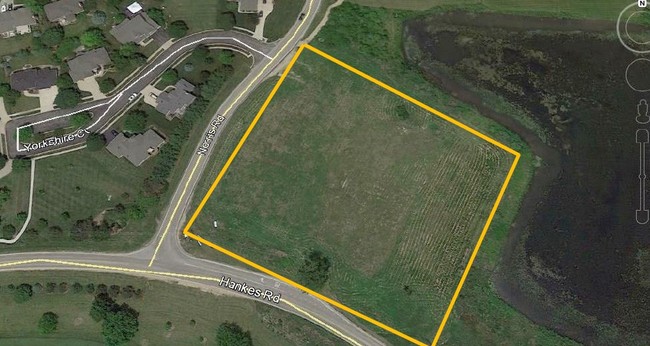
Property Record
Hankes & Norris New Rd, Aurora, IL 60506
This Property Is For Sale
NEARBY LISTINGS FOR SALE OR LEASE
Property Detail
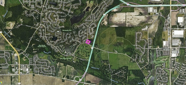
Hankes & Norris New Rd
Chicago-Naperville-Elgin, IL-IN
Prestbury
14-11-300-043
COMMERCIAL TACT D-1 OF PRESTBURY LT 1 (EX FOR THAT PT TAKEN FOR RD PER 2018K012002)
Commercialnec
Kane
AE
Illinois
17089C0316H
1
2024
1.78 AC
2024
Western East/West Corr
853100
Chicago
DEMOGRAPHICS near Hankes & Norris New Rd
1 Mile
3 Mile
5 Mile
2024 Total Population
3,447
28,720
89,089
2029 Population
3,480
28,677
89,795
Pop Growth 2024-2029
+ 0.96%
(0.15%)
+ 0.79%
Average Age
49
42
39
2024 Total Households
1,367
10,603
30,632
HH Growth 2024-2029
+ 1.10%
(0.14%)
+ 0.73%
Median Household Inc
$131,540
$102,227
$90,720
Avg Household Size
2.50
2.70
2.80
2024 Avg HH Vehicles
2.00
2.00
2.00
Median Home Value
$348,672
$294,337
$249,209
Median Year Built
2000
1994
1988
Nearby Places
Map Layers
Map Styles
 Street
 Aerial
- Restaurants
- Banks
- Shops
- Fitness
- Groceries
PUBLIC TRANSPORTATION
COMMUTER RAIL
Aurora Station (Burlington Northern-Santa Fe Railway Line - Northeast Illinois Regional Commuter Railroad (Metra))
DRIVE
WALK
Distance
Aurora Station (Burlington Northern-Santa Fe Railway Line - Northeast Illinois Regional Commuter Railroad (Metra))
16 min
6.3 mi
La Fox Station (Union Pacific West Line - Northeast Illinois Regional Commuter Railroad (Metra))
DRIVE
WALK
Distance
La Fox Station (Union Pacific West Line - Northeast Illinois Regional Commuter Railroad (Metra))
17 min
9.3 mi
AIRPORT
Chicago O'Hare International
DRIVE
WALK
Distance
Chicago O'Hare International
60 min
43.0 mi
Freight Ports
Port Milwaukee
DRIVE
WALK
Distance
Port Milwaukee
141 min
114.8 mi
Nearby Properties
Address
Land Use
TOTAL SIZE
Lot Size
Zoning
Address
Land Use
TOTAL SIZE
Lot Size
Zoning
Address
Land Use
TOTAL SIZE
Lot Size
Zoning
530,523 SF
37.65 AC
Address
Land Use
TOTAL SIZE
Lot Size
Zoning
18.81 AC
Address
Land Use
TOTAL SIZE
Lot Size
Zoning
28.35 AC
Address
Land Use
TOTAL SIZE
Lot Size
Zoning
25.58 AC
Address
Land Use
TOTAL SIZE
Lot Size
Zoning
394,560 SF
19.34 AC
Address
Land Use
TOTAL SIZE
Lot Size
Zoning
840,912 SF
49.56 AC
Address
Land Use
TOTAL SIZE
Lot Size
Zoning
8.22 AC
Address
Land Use
TOTAL SIZE
Lot Size
Zoning
83,424 SF
8.23 AC
Address
Land Use
TOTAL SIZE
Lot Size
Zoning
9.61 AC
Address
Land Use
TOTAL SIZE
Lot Size
Zoning
301,468 SF
44.12 AC
Address
Land Use
TOTAL SIZE
Lot Size
Zoning
Address
Land Use
TOTAL SIZE
Lot Size
Zoning
15.58 AC
Address
Land Use
TOTAL SIZE
Lot Size
Zoning
136,900 SF
3.63 AC
Address
Land Use
TOTAL SIZE
Lot Size
Zoning
3.85 AC
Address
Land Use
TOTAL SIZE
Lot Size
Zoning
Address
Land Use
TOTAL SIZE
Lot Size
Zoning
23.73 AC
Address
Land Use
TOTAL SIZE
Lot Size
Zoning
60,275 SF
3 AC
Address
Land Use
TOTAL SIZE
Lot Size
Zoning
139,494 SF
13.73 AC
Address
Land Use
TOTAL SIZE
Lot Size
Zoning
4.22 AC
Address
Land Use
TOTAL SIZE
Lot Size
Zoning
Address
Land Use
TOTAL SIZE
Lot Size
Zoning
1.14 AC
Address
Land Use
TOTAL SIZE
Lot Size
Zoning
84,870 SF
5.28 AC
Address
Land Use
TOTAL SIZE
Lot Size
Zoning
89,973 SF
3 AC
Address
Land Use
TOTAL SIZE
Lot Size
Zoning
70,556 SF
4.57 AC
Address
Land Use
TOTAL SIZE
Lot Size
Zoning
4.37 AC
Address
Land Use
TOTAL SIZE
Lot Size
Zoning
118,156 SF
11 AC
Address
Land Use
TOTAL SIZE
Lot Size
Zoning
98,716 SF
3.06 AC
Address
Land Use
TOTAL SIZE
Lot Size
Zoning
1.18 AC
Address
Land Use
TOTAL SIZE
Lot Size
Zoning
The World's #1 Commercial Real Estate Marketplace
Connect with us
© 2026 CoStar Group
The information above has been obtained from sources believed reliable. While we do not doubt its accuracy we have not verified it and make no guarantee, warranty or representation about it. It is your responsibility to independently confirm its accuracy and completeness. Any projections, opinions, assumptions, or estimates used are for example only and do not represent the current or future performance of the property. The value of this transaction to you depends on tax and other factors which should be evaluated by your tax, financial, and legal advisors. You and your advisors should conduct a careful, independent investigation of the property to determine to your satisfaction the suitability of the property for your needs.