Property Record
Ns # Ns, Hillsboro, OR 97123

Property Detail
Ns # Ns
Portland-Vancouver-Hillsboro, OR-WA
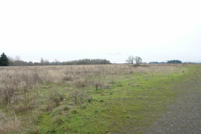
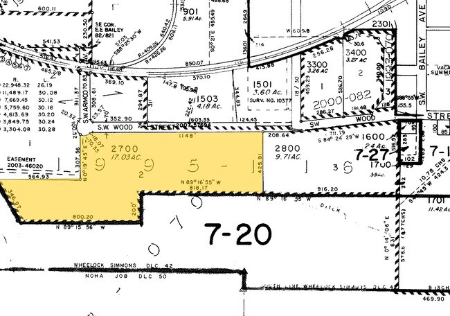
1995-116 PARTITION PLAT, LOT 2, ACRES 17.03
R2054122
WASHINGTON
Municipalproperty
Oregon
I-G
2
AE The base floodplain where base flood elevations are provided. AE Zones are now used on new format FIRMs instead of A1-A30 Zones.
17.03 AC
0
Sunset Corridor/Hillsboro
2026
Portland
0325011030
NEARBY LISTINGS FOR SALE OR LEASE
DEMOGRAPHICS near Ns # Ns
1 mile
3 mile
5 mile
2024 Total Population
4,044
61,852
120,827
2029 Population
4,155
62,745
123,009
Pop Growth 2024-2029
+ 2.74%
+ 1.44%
+ 1.81%
Average Age
38
39
39
2024 Total Households
1,208
20,362
42,367
HH Growth 2024-2029
+ 2.65%
+ 1.48%
+ 1.91%
Median Household Inc
$93,239
$101,916
$104,510
Avg Household Size
2.70
2.90
2.70
2024 Avg HH Vehicles
2.00
2.00
2.00
Median Home Value
$449,494
$492,054
$521,126
Median Year Built
1980
1984
1992
Nearby Places
Map Layers
Map Styles
 Street
 Aerial
Transit
 Traffic
 Biking
Places
Listings with unknown addresses are not visible on the map
- Restaurants
- Banks
- Shops
- Fitness
- Groceries
PUBLIC TRANSPORTATION
AIRPORT
Portland International
Drive
Walk
Distance
Portland International
53 min
31.1 mi
Freight Ports
Port of Portland
Drive
Walk
Distance
Port of Portland
36 min
20.1 mi
Nearby Properties
Address
Land Use
TOTAL SIZE
Lot Size
Zoning
Address
Land Use
TOTAL SIZE
Lot Size
Zoning
1,619,885 SF
115.71 AC
I-P
Address
Land Use
TOTAL SIZE
Lot Size
Zoning
9.97 AC
SCC-DT
Address
Land Use
TOTAL SIZE
Lot Size
Zoning
60.97 AC
INST
Address
Land Use
TOTAL SIZE
Lot Size
Zoning
5.83 AC
INST
Address
Land Use
TOTAL SIZE
Lot Size
Zoning
248,332 SF
4.26 AC
SCC-DT
Address
Land Use
TOTAL SIZE
Lot Size
Zoning
53.49 AC
SCFI
Address
Land Use
TOTAL SIZE
Lot Size
Zoning
256,652 SF
48.72 AC
SFR-7
Address
Land Use
TOTAL SIZE
Lot Size
Zoning
82,297 SF
175.24 AC
I-G
Address
Land Use
TOTAL SIZE
Lot Size
Zoning
0.06 AC
I-P
Address
Land Use
TOTAL SIZE
Lot Size
Zoning
252,251 SF
2.62 AC
SCC-DT
Address
Land Use
TOTAL SIZE
Lot Size
Zoning
3,616 SF
0.85 AC
SCC-DT
Address
Land Use
TOTAL SIZE
Lot Size
Zoning
43,041 SF
9.43 AC
SFR-7
Address
Land Use
TOTAL SIZE
Lot Size
Zoning
240,000 SF
39.66 AC
SFR-7
Address
Land Use
TOTAL SIZE
Lot Size
Zoning
354,705 SF
18.29 AC
C-G
Address
Land Use
TOTAL SIZE
Lot Size
Zoning
180,900 SF
6.33 AC
SCR-HD
Address
Land Use
TOTAL SIZE
Lot Size
Zoning
347,362 SF
14.06 AC
C-G
Address
Land Use
TOTAL SIZE
Lot Size
Zoning
285,970 SF
1.58 AC
SCC-DT
Address
Land Use
TOTAL SIZE
Lot Size
Zoning
1.22 AC
I-G
Address
Land Use
TOTAL SIZE
Lot Size
Zoning
83,200 SF
17.96 AC
SFR-7
Address
Land Use
TOTAL SIZE
Lot Size
Zoning
9.47 AC
SFR-7
Address
Land Use
TOTAL SIZE
Lot Size
Zoning
187,850 SF
0.82 AC
SCC-DT
Address
Land Use
TOTAL SIZE
Lot Size
Zoning
59,800 SF
0.66 AC
SCC-DT
Address
Land Use
TOTAL SIZE
Lot Size
Zoning
20.62 AC
I-G
Address
Land Use
TOTAL SIZE
Lot Size
Zoning
2.83 AC
GMU
Address
Land Use
TOTAL SIZE
Lot Size
Zoning
72,500 SF
11.48 AC
SCR-MD
Address
Land Use
TOTAL SIZE
Lot Size
Zoning
169,980 SF
14 AC
GMU
Address
Land Use
TOTAL SIZE
Lot Size
Zoning
20.69 AC
SCFI
Address
Land Use
TOTAL SIZE
Lot Size
Zoning
9.52 AC
SFR-7
Address
Land Use
TOTAL SIZE
Lot Size
Zoning
25,505 SF
14.17 AC
SFR-7
Address
Land Use
TOTAL SIZE
Lot Size
Zoning
56,813 SF
10.02 AC
SFR-7
The World's #1 Commercial Real Estate Marketplace
Connect with us
© 2026 CoStar Group
The information above has been obtained from sources believed reliable. While we do not doubt its accuracy we have not verified it and make no guarantee, warranty or representation about it. It is your responsibility to independently confirm its accuracy and completeness. Any projections, opinions, assumptions, or estimates used are for example only and do not represent the current or future performance of the property. The value of this transaction to you depends on tax and other factors which should be evaluated by your tax, financial, and legal advisors. You and your advisors should conduct a careful, independent investigation of the property to determine to your satisfaction the suitability of the property for your needs.