Property Record
Palisades Cir, Bentonville, AR 72712
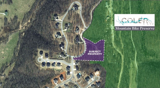


Property Detail
Palisades Cir
Fayetteville-Springdale-Rogers, AR
PLAT 04-1104 9/17/04, CORRECTION PLAT 3/29/2005 2005-409, REPLAT 1/23/2018 L201803624 & REPLAT 7/16/2018 L201836349
01-16293-000
BENTON
Residentialacreage
Arkansas
B and X Area of moderate flood hazard, usually the area between the limits of the 100-year and 500-year floods.
43
2025
3.69 AC
2025
Bentonville
020604
Fayetteville/Springdale/Rogers
NEARBY LISTINGS FOR SALE OR LEASE
DEMOGRAPHICS near Palisades Cir
1 mile
3 mile
5 mile
2025 Total Population
1,809
39,695
96,994
2030 Population
1,986
43,939
107,782
Pop Growth 2025-2030
+ 9.78%
+ 10.69%
+ 11.12%
Average Age
40
36
36
2025 Total Households
631
14,828
36,427
HH Growth 2025-2030
+ 9.98%
+ 11.14%
+ 11.43%
Median Household Inc
$188,220
$116,229
$111,584
Avg Household Size
2.90
2.60
2.60
2025 Avg HH Vehicles
2.00
2.00
2.00
Median Home Value
$618,881
$478,890
$412,908
Median Year Built
1997
2003
2005
Nearby Places
Map Layers
Map Styles
 Street
 Aerial
Layers
 Traffic
 Biking
Places
Listings with unknown addresses are not visible on the map
- Restaurants
- Banks
- Shops
- Fitness
- Groceries
PUBLIC TRANSPORTATION
AIRPORT
Northwest Arkansas Ntl
Drive
Walk
Distance
Northwest Arkansas Ntl
29 min
11.7 mi
SALE & LEASE HISTORY
LISTING DATE
SALE/LEASE

Oct 16, 2024
For Sale
Nov 05, 2025
For Sale
Apr 08, 2021
For Sale
Nearby Properties
Address
Land Use
TOTAL SIZE
Lot Size
Zoning
Address
Land Use
TOTAL SIZE
Lot Size
Zoning
552,541 SF
26.92 AC
Address
Land Use
TOTAL SIZE
Lot Size
Zoning
149,727 SF
1.32 AC
Address
Land Use
TOTAL SIZE
Lot Size
Zoning
187,529 SF
37.78 AC
Address
Land Use
TOTAL SIZE
Lot Size
Zoning
254,163 SF
10.98 AC
Address
Land Use
TOTAL SIZE
Lot Size
Zoning
247,292 SF
1.57 AC
Address
Land Use
TOTAL SIZE
Lot Size
Zoning
208,865 SF
7.73 AC
Address
Land Use
TOTAL SIZE
Lot Size
Zoning
256,469 SF
3.18 AC
Address
Land Use
TOTAL SIZE
Lot Size
Zoning
39,047 SF
1.43 AC
Address
Land Use
TOTAL SIZE
Lot Size
Zoning
64,098 SF
2.17 AC
Address
Land Use
TOTAL SIZE
Lot Size
Zoning
290,030 SF
Address
Land Use
TOTAL SIZE
Lot Size
Zoning
18,413 SF
0.68 AC
Address
Land Use
TOTAL SIZE
Lot Size
Zoning
239,145 SF
32.91 AC
Address
Land Use
TOTAL SIZE
Lot Size
Zoning
170,184 SF
10.51 AC
Address
Land Use
TOTAL SIZE
Lot Size
Zoning
148,317 SF
1.74 AC
Address
Land Use
TOTAL SIZE
Lot Size
Zoning
175,184 SF
1.12 AC
Address
Land Use
TOTAL SIZE
Lot Size
Zoning
179,182 SF
19.21 AC
Address
Land Use
TOTAL SIZE
Lot Size
Zoning
27,874 SF
0.48 AC
Address
Land Use
TOTAL SIZE
Lot Size
Zoning
21,846 SF
10.20 AC
Address
Land Use
TOTAL SIZE
Lot Size
Zoning
147,832 SF
21.01 AC
Address
Land Use
TOTAL SIZE
Lot Size
Zoning
228,855 SF
1.21 AC
Address
Land Use
TOTAL SIZE
Lot Size
Zoning
68,423 SF
1.22 AC
Address
Land Use
TOTAL SIZE
Lot Size
Zoning
161,340 SF
4.67 AC
Address
Land Use
TOTAL SIZE
Lot Size
Zoning
71,586 SF
1.24 AC
Address
Land Use
TOTAL SIZE
Lot Size
Zoning
84,697 SF
10.08 AC
Address
Land Use
TOTAL SIZE
Lot Size
Zoning
23,882 SF
1.57 AC
Address
Land Use
TOTAL SIZE
Lot Size
Zoning
177,614 SF
15.95 AC
Address
Land Use
TOTAL SIZE
Lot Size
Zoning
220,484 SF
5.05 AC
Address
Land Use
TOTAL SIZE
Lot Size
Zoning
139,940 SF
15 AC
Address
Land Use
TOTAL SIZE
Lot Size
Zoning
84,908 SF
5.63 AC
Address
Land Use
TOTAL SIZE
Lot Size
Zoning
138,513 SF
15.06 AC
The World's #1 Commercial Real Estate Marketplace
Connect with us
© 2026 CoStar Group
The information above has been obtained from sources believed reliable. While we do not doubt its accuracy we have not verified it and make no guarantee, warranty or representation about it. It is your responsibility to independently confirm its accuracy and completeness. Any projections, opinions, assumptions, or estimates used are for example only and do not represent the current or future performance of the property. The value of this transaction to you depends on tax and other factors which should be evaluated by your tax, financial, and legal advisors. You and your advisors should conduct a careful, independent investigation of the property to determine to your satisfaction the suitability of the property for your needs.