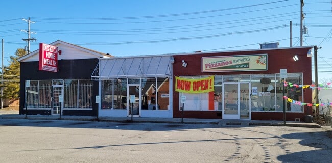
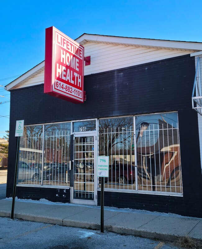
Property Record
0 Parsons Ave, Columbus Grove, OH 45830
Property Detail
0 Parsons Ave
Columbus, OH
802-4 PARSONS AVE SWAYNE PT LOT 60 & ALL 61
010-046344
FRANKLIN
Storebuilding
Ohio
B and X Area of moderate flood hazard, usually the area between the limits of the 100-year and 500-year floods.
60
2024
0.16 AC
2025
Southeast
030500
Columbus
NEARBY LISTINGS FOR SALE OR LEASE
DEMOGRAPHICS near 0 Parsons Ave
1 mile
3 mile
5 mile
2025 Total Population
25,790
126,447
356,712
2030 Population
27,204
133,781
372,670
Pop Growth 2025-2030
+ 5.48%
+ 5.80%
+ 4.47%
Average Age
37
37
36
2025 Total Households
13,003
60,560
150,576
HH Growth 2025-2030
+ 5.44%
+ 5.97%
+ 4.72%
Median Household Inc
$70,590
$64,045
$54,956
Avg Household Size
1.90
2.00
2.20
2025 Avg HH Vehicles
1.00
1.00
2.00
Median Home Value
$371,457
$347,830
$252,740
Median Year Built
1947
1957
1962
Nearby Places
Map Layers
Map Styles
 Street
 Aerial
Layers
 Traffic
 Biking
Places
Listings with unknown addresses are not visible on the map
- Restaurants
- Banks
- Shops
- Fitness
- Groceries
PUBLIC TRANSPORTATION
AIRPORT
John Glenn Columbus International
Drive
Walk
Distance
John Glenn Columbus International
13 min
8.0 mi
Rickenbacker International
Drive
Walk
Distance
Rickenbacker International
23 min
10.2 mi
SALE & LEASE HISTORY
LISTING DATE
SALE/LEASE

Nov 17, 2022
For Lease
Nov 11, 2016
For Lease
Nearby Properties
Address
Land Use
TOTAL SIZE
Lot Size
Zoning
Address
Land Use
TOTAL SIZE
Lot Size
Zoning
1,949,795 SF
20.56 AC
Address
Land Use
TOTAL SIZE
Lot Size
Zoning
1,467,891 SF
10.49 AC
Address
Land Use
TOTAL SIZE
Lot Size
Zoning
29,312 SF
10.72 AC
Address
Land Use
TOTAL SIZE
Lot Size
Zoning
717,666 SF
17.99 AC
Address
Land Use
TOTAL SIZE
Lot Size
Zoning
838,846 SF
3.73 AC
Address
Land Use
TOTAL SIZE
Lot Size
Zoning
13.50 AC
Address
Land Use
TOTAL SIZE
Lot Size
Zoning
304,340 SF
3.86 AC
Address
Land Use
TOTAL SIZE
Lot Size
Zoning
477,854 SF
0.72 AC
Address
Land Use
TOTAL SIZE
Lot Size
Zoning
798,272 SF
9.94 AC
Address
Land Use
TOTAL SIZE
Lot Size
Zoning
832,673 SF
2.87 AC
Address
Land Use
TOTAL SIZE
Lot Size
Zoning
972,594 SF
0.84 AC
Address
Land Use
TOTAL SIZE
Lot Size
Zoning
385,225 SF
5.89 AC
Address
Land Use
TOTAL SIZE
Lot Size
Zoning
481,704 SF
0.92 AC
Address
Land Use
TOTAL SIZE
Lot Size
Zoning
479,979 SF
5.43 AC
Address
Land Use
TOTAL SIZE
Lot Size
Zoning
1,113,919 SF
1.63 AC
Address
Land Use
TOTAL SIZE
Lot Size
Zoning
1,462,053 SF
0.21 AC
Address
Land Use
TOTAL SIZE
Lot Size
Zoning
484,662 SF
2.28 AC
Address
Land Use
TOTAL SIZE
Lot Size
Zoning
501,624 SF
1.23 AC
Address
Land Use
TOTAL SIZE
Lot Size
Zoning
470,630 SF
0.57 AC
Address
Land Use
TOTAL SIZE
Lot Size
Zoning
339,231 SF
0.73 AC
Address
Land Use
TOTAL SIZE
Lot Size
Zoning
1,013,906 SF
1 AC
Address
Land Use
TOTAL SIZE
Lot Size
Zoning
1,158,978 SF
5.02 AC
Address
Land Use
TOTAL SIZE
Lot Size
Zoning
669,626 SF
0.97 AC
Address
Land Use
TOTAL SIZE
Lot Size
Zoning
892,833 SF
5.27 AC
Address
Land Use
TOTAL SIZE
Lot Size
Zoning
560,146 SF
63.19 AC
Address
Land Use
TOTAL SIZE
Lot Size
Zoning
459,012 SF
3.71 AC
Address
Land Use
TOTAL SIZE
Lot Size
Zoning
657,089 SF
9.74 AC
Address
Land Use
TOTAL SIZE
Lot Size
Zoning
19,117 SF
7.28 AC
Address
Land Use
TOTAL SIZE
Lot Size
Zoning
697,192 SF
2.72 AC
Address
Land Use
TOTAL SIZE
Lot Size
Zoning
595,932 SF
2.74 AC
The World's #1 Commercial Real Estate Marketplace
Connect with us
© 2026 CoStar Group
The information above has been obtained from sources believed reliable. While we do not doubt its accuracy we have not verified it and make no guarantee, warranty or representation about it. It is your responsibility to independently confirm its accuracy and completeness. Any projections, opinions, assumptions, or estimates used are for example only and do not represent the current or future performance of the property. The value of this transaction to you depends on tax and other factors which should be evaluated by your tax, financial, and legal advisors. You and your advisors should conduct a careful, independent investigation of the property to determine to your satisfaction the suitability of the property for your needs.