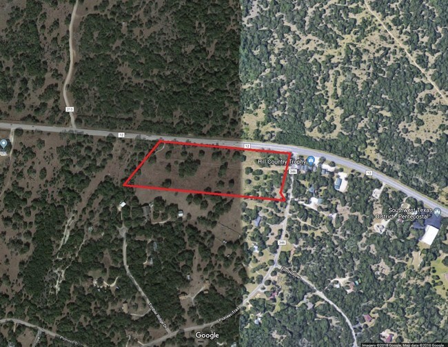
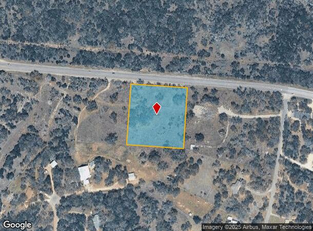
Property Record
Ranch Rd 12, San Marcos, TX 78666
Property Detail
Ranch Rd 12
Austin-Round Rock-San Marcos, TX
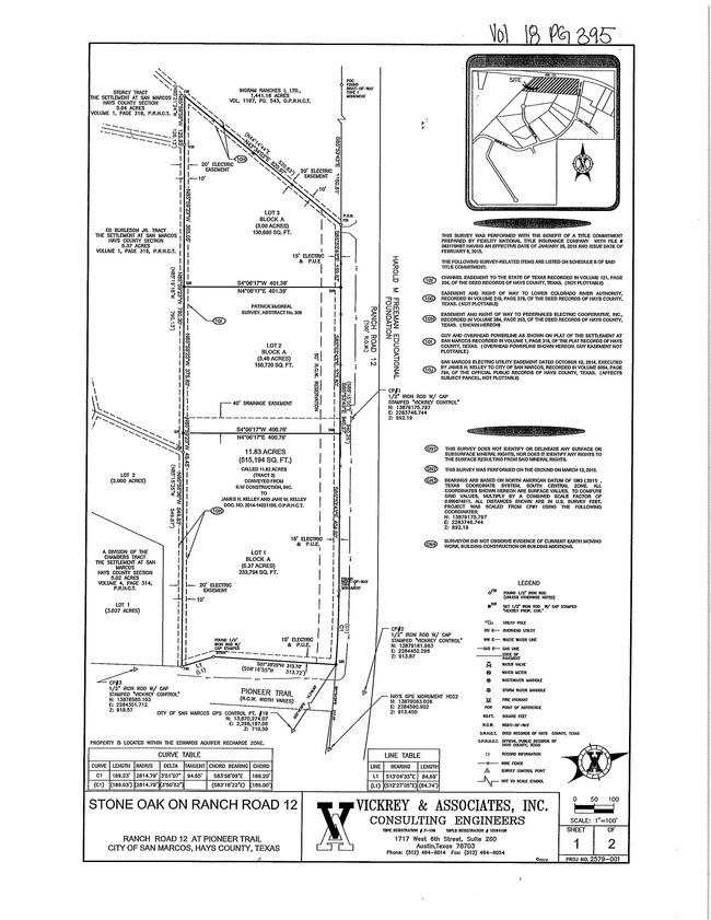
Stone Oak On Ranch Road 12
R147885
STONE OAK ON RANCH ROAD 12, BLOCK A, LOT 2, ACRES 3.46
Ruralagriculturalresidence
Hays
X
Texas
48209C0370F
2
2024
3.46 AC
2025
Hays County
010100
Austin
NEARBY LISTINGS FOR SALE OR LEASE
DEMOGRAPHICS near Ranch Rd 12
1 mile
3 mile
5 mile
2024 Total Population
1,482
24,644
60,525
2029 Population
1,781
28,284
69,505
Pop Growth 2024-2029
+ 20.18%
+ 14.77%
+ 14.84%
Average Age
45
36
34
2024 Total Households
569
9,595
24,602
HH Growth 2024-2029
+ 21.09%
+ 16.46%
+ 16.23%
Median Household Inc
$139,285
$66,931
$53,242
Avg Household Size
2.60
2.30
2.20
2024 Avg HH Vehicles
2.00
2.00
2.00
Median Home Value
$707,353
$398,675
$366,249
Median Year Built
2009
1996
1996
Nearby Places
Map Layers
Map Styles
 Street
 Aerial
Transit
 Traffic
 Biking
Places
Listings with unknown addresses are not visible on the map
- Restaurants
- Banks
- Shops
- Fitness
- Groceries
PUBLIC TRANSPORTATION
COMMUTER RAIL
San Marcos Amtrak (Texas Eagle - Amtrak)
Drive
Walk
Distance
San Marcos Amtrak (Texas Eagle - Amtrak)
9 min
5.0 mi
AIRPORT
Austin-Bergstrom International
Drive
Walk
Distance
Austin-Bergstrom International
54 min
42.3 mi
Freight Ports
Calhoun Port
Drive
Walk
Distance
Calhoun Port
172 min
139.9 mi
SALE & LEASE HISTORY
LISTING DATE
SALE/LEASE

Mar 08, 2018
For Sale
Nearby Properties
Address
Land Use
TOTAL SIZE
Lot Size
Zoning
Address
Land Use
TOTAL SIZE
Lot Size
Zoning
458,948 SF
35.43 AC
Address
Land Use
TOTAL SIZE
Lot Size
Zoning
402,983 SF
21.31 AC
Address
Land Use
TOTAL SIZE
Lot Size
Zoning
4,175 SF
3,380.82 AC
Address
Land Use
TOTAL SIZE
Lot Size
Zoning
343,094 SF
39.30 AC
Address
Land Use
TOTAL SIZE
Lot Size
Zoning
181,400 SF
13.07 AC
Address
Land Use
TOTAL SIZE
Lot Size
Zoning
140,844 SF
17.05 AC
Address
Land Use
TOTAL SIZE
Lot Size
Zoning
140,866 SF
10.08 AC
Address
Land Use
TOTAL SIZE
Lot Size
Zoning
70,340 SF
8.36 AC
Address
Land Use
TOTAL SIZE
Lot Size
Zoning
75.15 AC
Address
Land Use
TOTAL SIZE
Lot Size
Zoning
326.30 AC
Address
Land Use
TOTAL SIZE
Lot Size
Zoning
89,700 SF
8.71 AC
Address
Land Use
TOTAL SIZE
Lot Size
Zoning
Address
Land Use
TOTAL SIZE
Lot Size
Zoning
18.80 AC
Address
Land Use
TOTAL SIZE
Lot Size
Zoning
158.48 AC
Address
Land Use
TOTAL SIZE
Lot Size
Zoning
7,140 SF
3.30 AC
Address
Land Use
TOTAL SIZE
Lot Size
Zoning
45,945 SF
11.69 AC
Address
Land Use
TOTAL SIZE
Lot Size
Zoning
56,976 SF
5.80 AC
Address
Land Use
TOTAL SIZE
Lot Size
Zoning
249.19 AC
Address
Land Use
TOTAL SIZE
Lot Size
Zoning
107.01 AC
Address
Land Use
TOTAL SIZE
Lot Size
Zoning
9,592 SF
5.08 AC
Address
Land Use
TOTAL SIZE
Lot Size
Zoning
20,450 SF
15 AC
Address
Land Use
TOTAL SIZE
Lot Size
Zoning
55,460 SF
2.41 AC
Address
Land Use
TOTAL SIZE
Lot Size
Zoning
Address
Land Use
TOTAL SIZE
Lot Size
Zoning
216.51 AC
Address
Land Use
TOTAL SIZE
Lot Size
Zoning
92.73 AC
Address
Land Use
TOTAL SIZE
Lot Size
Zoning
Address
Land Use
TOTAL SIZE
Lot Size
Zoning
3,459 SF
19.41 AC
Address
Land Use
TOTAL SIZE
Lot Size
Zoning
Address
Land Use
TOTAL SIZE
Lot Size
Zoning
330 SF
150.17 AC
Address
Land Use
TOTAL SIZE
Lot Size
Zoning
14,675 SF
2.37 AC
The World's #1 Commercial Real Estate Marketplace
Connect with us
© 2026 CoStar Group
The information above has been obtained from sources believed reliable. While we do not doubt its accuracy we have not verified it and make no guarantee, warranty or representation about it. It is your responsibility to independently confirm its accuracy and completeness. Any projections, opinions, assumptions, or estimates used are for example only and do not represent the current or future performance of the property. The value of this transaction to you depends on tax and other factors which should be evaluated by your tax, financial, and legal advisors. You and your advisors should conduct a careful, independent investigation of the property to determine to your satisfaction the suitability of the property for your needs.