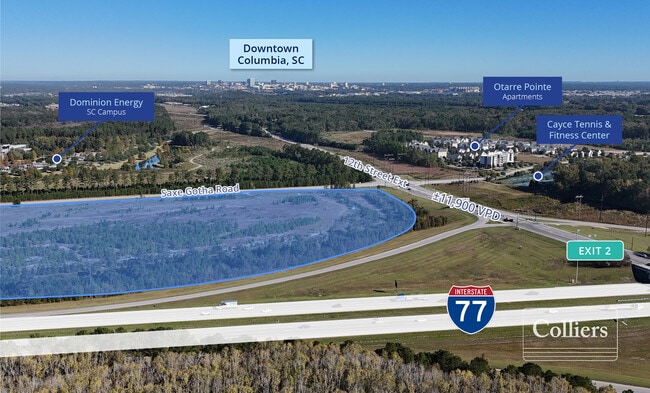
Property Record
Saxe Gotha Rd, West Columbia, SC 29172


Save to a Folder
{{folder.Name}}
{{folder.ListingIds.length}} Properties
{{folder.ListingIds.length}} Property
Create a New Folder
Property Detail
Saxe Gotha Rd
Columbia, SC
NONE
006897-01-070
LEXINGTON
Commercialacreage
South Carolina
B and X Area of moderate flood hazard, usually the area between the limits of the 100-year and 500-year floods.
35.70 AC
2025
Cayce/West Columbia
2024
Columbia
020707
NEARBY LISTINGS FOR SALE OR LEASE
DEMOGRAPHICS near Saxe Gotha Rd
1 mile
3 mile
5 mile
2025 Total Population
684
13,077
77,418
2030 Population
714
13,831
81,124
Pop Growth 2025-2030
+ 4.39%
+ 5.77%
+ 4.79%
Average Age
39
38
36
2025 Total Households
319
5,879
32,631
HH Growth 2025-2030
+ 4.70%
+ 6.17%
+ 5.26%
Median Household Inc
$98,749
$56,386
$50,395
Avg Household Size
2.10
2.20
2.10
2025 Avg HH Vehicles
2.00
2.00
2.00
Median Home Value
$269,999
$164,533
$199,116
Median Year Built
2006
1981
1976
Nearby Places
Map Layers
Map Styles
 Street
 Aerial
Layers
 Traffic
 Biking
Places
Listings with unknown addresses are not visible on the map
- Restaurants
- Banks
- Shops
- Fitness
- Groceries
PUBLIC TRANSPORTATION
COMMUTER RAIL
Columbia Amtrak Station (Silver Star - Amtrak)
Drive
Walk
Distance
Columbia Amtrak Station (Silver Star - Amtrak)
13 min
6.8 mi
AIRPORT
Columbia Metro
Drive
Walk
Distance
Columbia Metro
19 min
8.6 mi
Freight Ports
North Charleston Terminal
Drive
Walk
Distance
North Charleston Terminal
113 min
100.0 mi
Nearby Properties
Address
Land Use
TOTAL SIZE
Lot Size
Zoning
Address
Land Use
TOTAL SIZE
Lot Size
Zoning
300,636 SF
21.58 AC
LI
Address
Land Use
TOTAL SIZE
Lot Size
Zoning
254,900 SF
14 AC
M-1
Address
Land Use
TOTAL SIZE
Lot Size
Zoning
174,424 SF
7.66 AC
LI
Address
Land Use
TOTAL SIZE
Lot Size
Zoning
1,253,820 SF
87.15 AC
Address
Land Use
TOTAL SIZE
Lot Size
Zoning
62,145 SF
5.57 AC
M-1
Address
Land Use
TOTAL SIZE
Lot Size
Zoning
466,400 SF
52.42 AC
ID
Address
Land Use
TOTAL SIZE
Lot Size
Zoning
16,112 SF
124.65 AC
RU
Address
Land Use
TOTAL SIZE
Lot Size
Zoning
37,400 SF
11.42 AC
HI
Address
Land Use
TOTAL SIZE
Lot Size
Zoning
48.56 AC
M-1
Address
Land Use
TOTAL SIZE
Lot Size
Zoning
42,500 SF
2.70 AC
M-1
Address
Land Use
TOTAL SIZE
Lot Size
Zoning
4,586 SF
19.15 AC
Address
Land Use
TOTAL SIZE
Lot Size
Zoning
22,000 SF
2.62 AC
M-1
Address
Land Use
TOTAL SIZE
Lot Size
Zoning
87,936 SF
4.40 AC
HI
Address
Land Use
TOTAL SIZE
Lot Size
Zoning
1,218 SF
8.99 AC
RG
Address
Land Use
TOTAL SIZE
Lot Size
Zoning
24.83 AC
HI
Address
Land Use
TOTAL SIZE
Lot Size
Zoning
5,040 SF
4.50 AC
M-1
Address
Land Use
TOTAL SIZE
Lot Size
Zoning
28,686 SF
1.94 AC
M-1
Address
Land Use
TOTAL SIZE
Lot Size
Zoning
5.75 AC
D-1
Address
Land Use
TOTAL SIZE
Lot Size
Zoning
67,995 SF
3.25 AC
HI
Address
Land Use
TOTAL SIZE
Lot Size
Zoning
52,000 SF
2.63 AC
M-1
Address
Land Use
TOTAL SIZE
Lot Size
Zoning
297,500 SF
20.26 AC
ID
Address
Land Use
TOTAL SIZE
Lot Size
Zoning
39,248 SF
2.13 AC
HI
Address
Land Use
TOTAL SIZE
Lot Size
Zoning
30,219 SF
1.80 AC
M-1
Address
Land Use
TOTAL SIZE
Lot Size
Zoning
8,118 SF
10.98 AC
RG
Address
Land Use
TOTAL SIZE
Lot Size
Zoning
180,000 SF
27.57 AC
ID
Address
Land Use
TOTAL SIZE
Lot Size
Zoning
26,400 SF
1.06 AC
M-1
Address
Land Use
TOTAL SIZE
Lot Size
Zoning
181,440 SF
10.69 AC
ID
Address
Land Use
TOTAL SIZE
Lot Size
Zoning
34,200 SF
1.82 AC
M-1
Address
Land Use
TOTAL SIZE
Lot Size
Zoning
9,800 SF
13.52 AC
ID
Address
Land Use
TOTAL SIZE
Lot Size
Zoning
26,400 SF
1.07 AC
M-1
The World's #1 Commercial Real Estate Marketplace
Connect with us
© 2026 CoStar Group
The information above has been obtained from sources believed reliable. While we do not doubt its accuracy we have not verified it and make no guarantee, warranty or representation about it. It is your responsibility to independently confirm its accuracy and completeness. Any projections, opinions, assumptions, or estimates used are for example only and do not represent the current or future performance of the property. The value of this transaction to you depends on tax and other factors which should be evaluated by your tax, financial, and legal advisors. You and your advisors should conduct a careful, independent investigation of the property to determine to your satisfaction the suitability of the property for your needs.