Property Record
Sheraton Ln, Cincinnati, OH 45246
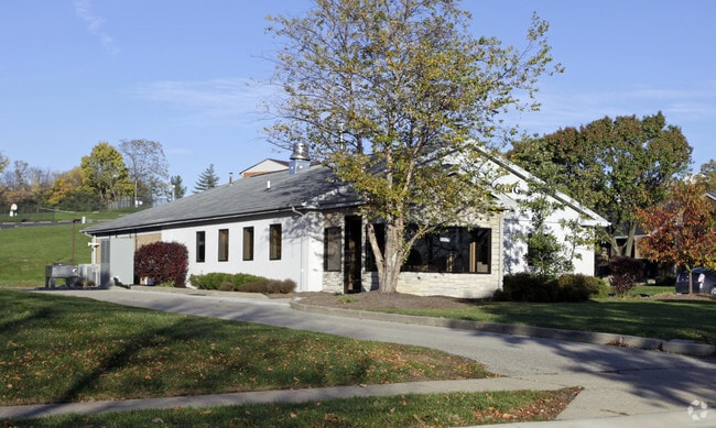

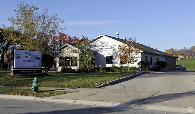
Property Detail
Sheraton Ln
Cincinnati, OH-KY-IN
SHERATON LN 150 X 285 LOT 4 CROSSINGS OF SPRINGDALE THE - PHASE
599-0050-0409
HAMILTON
Medicalbuilding
Ohio
B and X Area of moderate flood hazard, usually the area between the limits of the 100-year and 500-year floods.
4
2025
0.98 AC
2025
Tri-County I-275
022301
Cincinnati/Dayton
2,904 SF
NEARBY LISTINGS FOR SALE OR LEASE
DEMOGRAPHICS near Sheraton Ln
1 mile
3 mile
5 mile
2025 Total Population
8,523
56,317
148,054
2030 Population
8,868
57,249
150,582
Pop Growth 2025-2030
+ 4.05%
+ 1.65%
+ 1.71%
Average Age
42
40
40
2025 Total Households
3,795
22,933
58,317
HH Growth 2025-2030
+ 4.53%
+ 1.87%
+ 1.79%
Median Household Inc
$65,232
$68,957
$77,382
Avg Household Size
2.10
2.40
2.50
2025 Avg HH Vehicles
2.00
2.00
2.00
Median Home Value
$175,401
$196,159
$240,861
Median Year Built
1977
1975
1976
Nearby Places
Map Layers
Map Styles
 Street
 Aerial
Layers
 Traffic
 Biking
Places
Listings with unknown addresses are not visible on the map
- Restaurants
- Banks
- Shops
- Fitness
- Groceries
PUBLIC TRANSPORTATION
AIRPORT
Cincinnati/Northern Kentucky International
Drive
Walk
Distance
Cincinnati/Northern Kentucky International
52 min
32.8 mi
Freight Ports
Port of Toledo
Drive
Walk
Distance
Port of Toledo
226 min
193.7 mi
Nearby Properties
Address
Land Use
TOTAL SIZE
Lot Size
Zoning
Address
Land Use
TOTAL SIZE
Lot Size
Zoning
47.52 AC
Address
Land Use
TOTAL SIZE
Lot Size
Zoning
61.62 AC
Address
Land Use
TOTAL SIZE
Lot Size
Zoning
38,880 SF
20.93 AC
Address
Land Use
TOTAL SIZE
Lot Size
Zoning
28.80 AC
Address
Land Use
TOTAL SIZE
Lot Size
Zoning
34.60 AC
Address
Land Use
TOTAL SIZE
Lot Size
Zoning
15.33 AC
Address
Land Use
TOTAL SIZE
Lot Size
Zoning
87,612 SF
16.29 AC
R3
Address
Land Use
TOTAL SIZE
Lot Size
Zoning
1,363,493 SF
75.28 AC
Address
Land Use
TOTAL SIZE
Lot Size
Zoning
10.85 AC
Address
Land Use
TOTAL SIZE
Lot Size
Zoning
559,332 SF
29.30 AC
Address
Land Use
TOTAL SIZE
Lot Size
Zoning
Address
Land Use
TOTAL SIZE
Lot Size
Zoning
706,768 SF
35.92 AC
Address
Land Use
TOTAL SIZE
Lot Size
Zoning
782,765 SF
33.15 AC
Address
Land Use
TOTAL SIZE
Lot Size
Zoning
18.77 AC
Address
Land Use
TOTAL SIZE
Lot Size
Zoning
68.49 AC
Address
Land Use
TOTAL SIZE
Lot Size
Zoning
498,300 SF
14.86 AC
Address
Land Use
TOTAL SIZE
Lot Size
Zoning
334,887 SF
16.16 AC
Address
Land Use
TOTAL SIZE
Lot Size
Zoning
342,284 SF
36.35 AC
Address
Land Use
TOTAL SIZE
Lot Size
Zoning
26.63 AC
Address
Land Use
TOTAL SIZE
Lot Size
Zoning
39.89 AC
Address
Land Use
TOTAL SIZE
Lot Size
Zoning
536,648 SF
22.28 AC
Address
Land Use
TOTAL SIZE
Lot Size
Zoning
467,263 SF
27.27 AC
ADV
Address
Land Use
TOTAL SIZE
Lot Size
Zoning
567,230 SF
31.45 AC
Address
Land Use
TOTAL SIZE
Lot Size
Zoning
115,446 SF
20.08 AC
Address
Land Use
TOTAL SIZE
Lot Size
Zoning
2.24 AC
Address
Land Use
TOTAL SIZE
Lot Size
Zoning
25,098 SF
21.31 AC
Address
Land Use
TOTAL SIZE
Lot Size
Zoning
438,182 SF
28.80 AC
Address
Land Use
TOTAL SIZE
Lot Size
Zoning
25.89 AC
Address
Land Use
TOTAL SIZE
Lot Size
Zoning
482,499 SF
27.83 AC
Address
Land Use
TOTAL SIZE
Lot Size
Zoning
1,700 SF
35.39 AC
The World's #1 Commercial Real Estate Marketplace
Connect with us
© 2026 CoStar Group
The information above has been obtained from sources believed reliable. While we do not doubt its accuracy we have not verified it and make no guarantee, warranty or representation about it. It is your responsibility to independently confirm its accuracy and completeness. Any projections, opinions, assumptions, or estimates used are for example only and do not represent the current or future performance of the property. The value of this transaction to you depends on tax and other factors which should be evaluated by your tax, financial, and legal advisors. You and your advisors should conduct a careful, independent investigation of the property to determine to your satisfaction the suitability of the property for your needs.