Property Record
1909 Unknown, Cocoa, FL 32926

NEARBY LISTINGS FOR SALE OR LEASE
Property Detail
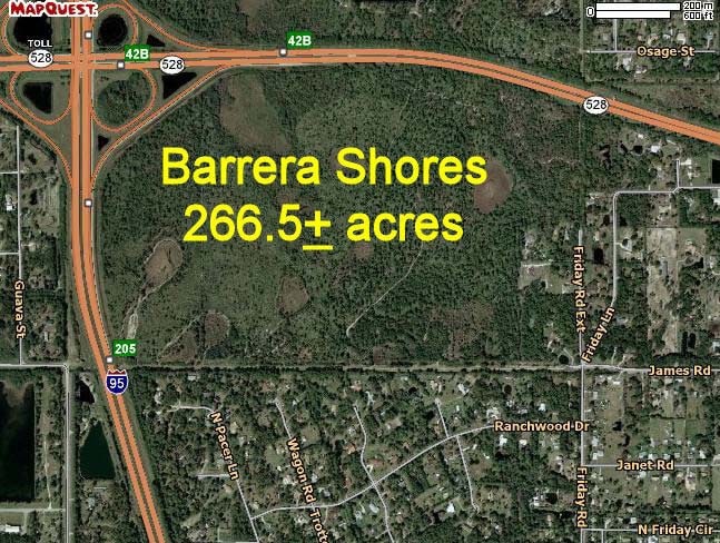
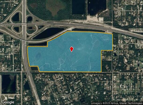
1909 Unknown
24-35-10-00-00502.0-0000.00
PART OF SECT LYING S OF SR 528 (BEELINE), E OF I-95 R/W & N OF JAMES RD EXC E 1/2 OF SE 1/4 OF SE 1/4, ORB 5776 PG 2751, ORB 7000 PG 2377 & ORB 7434 PG 1216
Countyproperty
Brevard
A
Florida
12009C0320H
212.10 AC
2024
Brevard County
2025
Orlando
0712001041
Palm Bay-Melbourne-Titusville, FL
DEMOGRAPHICS near 1909 Unknown
1 Mile
3 Mile
5 Mile
2024 Total Population
1,507
13,506
50,954
2029 Population
1,633
14,704
55,581
Pop Growth 2024-2029
+ 8.36%
+ 8.87%
+ 9.08%
Average Age
48
46
43
2024 Total Households
595
5,447
20,460
HH Growth 2024-2029
+ 8.07%
+ 8.70%
+ 8.90%
Median Household Inc
$90,492
$77,199
$53,570
Avg Household Size
2.50
2.40
2.40
2024 Avg HH Vehicles
3.00
2.00
2.00
Median Home Value
$321,678
$264,630
$230,858
Median Year Built
1987
1989
1985
Nearby Places
Map Layers
Map Styles
 Street
 Aerial
- Restaurants
- Banks
- Shops
- Fitness
- Groceries
PUBLIC TRANSPORTATION
AIRPORT
Melbourne Orlando International
DRIVE
WALK
Distance
Melbourne Orlando International
42 min
28.4 mi
Freight Ports
Port Canaveral
DRIVE
WALK
Distance
Port Canaveral
24 min
14.2 mi
SALE & LEASE HISTORY
LISTING DATE
SALE/LEASE

Aug 25, 2021
For Sale
Nearby Properties
Address
Land Use
TOTAL SIZE
Lot Size
Zoning
Address
Land Use
TOTAL SIZE
Lot Size
Zoning
658,069 SF
268.45 AC
RU17
Address
Land Use
TOTAL SIZE
Lot Size
Zoning
335,014 SF
185.59 AC
M2
Address
Land Use
TOTAL SIZE
Lot Size
Zoning
307,934 SF
13.66 AC
RU215
Address
Land Use
TOTAL SIZE
Lot Size
Zoning
176,670 SF
13.49 AC
CG
Address
Land Use
TOTAL SIZE
Lot Size
Zoning
96,878 SF
17.47 AC
CN
Address
Land Use
TOTAL SIZE
Lot Size
Zoning
144,430 SF
14.02 AC
M2
Address
Land Use
TOTAL SIZE
Lot Size
Zoning
52,398 SF
9.68 AC
M2
Address
Land Use
TOTAL SIZE
Lot Size
Zoning
65,316 SF
956.57 AC
GML(H)
Address
Land Use
TOTAL SIZE
Lot Size
Zoning
66,210 SF
12.22 AC
M2
Address
Land Use
TOTAL SIZE
Lot Size
Zoning
78,343 SF
8.50 AC
CG
Address
Land Use
TOTAL SIZE
Lot Size
Zoning
13,616 SF
12.92 AC
Address
Land Use
TOTAL SIZE
Lot Size
Zoning
74,632 SF
8.84 AC
M2
Address
Land Use
TOTAL SIZE
Lot Size
Zoning
49,460 SF
5 AC
CG
Address
Land Use
TOTAL SIZE
Lot Size
Zoning
37,125 SF
6.40 AC
M2
Address
Land Use
TOTAL SIZE
Lot Size
Zoning
2,520 SF
69.41 AC
IU
Address
Land Use
TOTAL SIZE
Lot Size
Zoning
19.77 AC
Address
Land Use
TOTAL SIZE
Lot Size
Zoning
27,271 SF
10 AC
M2
Address
Land Use
TOTAL SIZE
Lot Size
Zoning
64,221 SF
20.23 AC
M2
Address
Land Use
TOTAL SIZE
Lot Size
Zoning
19,051 SF
1.92 AC
M2
Address
Land Use
TOTAL SIZE
Lot Size
Zoning
39,290 SF
3 AC
M2
Address
Land Use
TOTAL SIZE
Lot Size
Zoning
36,303 SF
2.12 AC
M1
Address
Land Use
TOTAL SIZE
Lot Size
Zoning
10.47 AC
M2
Address
Land Use
TOTAL SIZE
Lot Size
Zoning
18,519 SF
14.50 AC
RU17
Address
Land Use
TOTAL SIZE
Lot Size
Zoning
7,846 SF
10 AC
CN
Address
Land Use
TOTAL SIZE
Lot Size
Zoning
30,120 SF
2.32 AC
M1
Address
Land Use
TOTAL SIZE
Lot Size
Zoning
41.73 AC
CG
Address
Land Use
TOTAL SIZE
Lot Size
Zoning
29.34 AC
M2
Address
Land Use
TOTAL SIZE
Lot Size
Zoning
41,272 SF
5.12 AC
IU
Address
Land Use
TOTAL SIZE
Lot Size
Zoning
7,872 SF
9.87 AC
M2
The World's #1 Commercial Real Estate Marketplace
Connect with us
© 2025 CoStar Group
The information above has been obtained from sources believed reliable. While we do not doubt its accuracy we have not verified it and make no guarantee, warranty or representation about it. It is your responsibility to independently confirm its accuracy and completeness. Any projections, opinions, assumptions, or estimates used are for example only and do not represent the current or future performance of the property. The value of this transaction to you depends on tax and other factors which should be evaluated by your tax, financial, and legal advisors. You and your advisors should conduct a careful, independent investigation of the property to determine to your satisfaction the suitability of the property for your needs.