Property Record
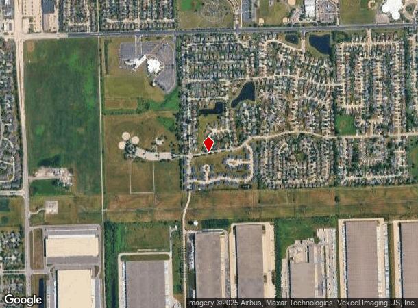
W Belmont Dr At West Taylor Rd, Romeoville, IL 60446
This Property Is For Sale
Current Lease Availabilities
NEARBY LISTINGS FOR SALE OR LEASE
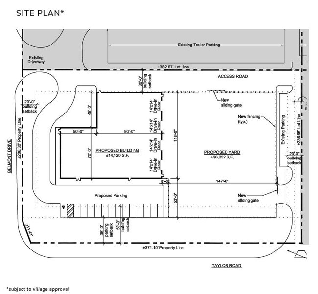
Property Detail
W Belmont Dr At West Taylor Rd
Chicago-Naperville-Elgin, IL-IN
Paragon Business Park
11-04-04-301-018
LOT 2 IN PARAGON BUSINESS PARK RESUB NO 2, OF LOTS 1, 2, 3, 8, 9 10 IN PARAGON BUSINESS PARK, BEING A SUB OF PRT OF W1/2 OF
Industrialacreage
Will
X
Illinois
17197C0065G
2
2024
2.12 AC
2024
South I-55 Corridor
880508
Chicago
DEMOGRAPHICS near W Belmont Dr At West Taylor Rd
1 mile
3 mile
5 mile
2024 Total Population
6,364
45,815
130,526
2029 Population
6,321
45,675
130,048
Pop Growth 2024-2029
(0.68%)
(0.31%)
(0.37%)
Average Age
37
40
39
2024 Total Households
1,962
16,317
44,705
HH Growth 2024-2029
(0.66%)
(0.19%)
(0.34%)
Median Household Inc
$89,520
$83,502
$87,748
Avg Household Size
3.20
2.80
2.80
2024 Avg HH Vehicles
2.00
2.00
2.00
Median Home Value
$194,630
$226,399
$246,282
Median Year Built
1984
1995
1994
Nearby Places
Map Layers
Map Styles
 Street
 Aerial
Transit
 Traffic
 Biking
Places
Listings with unknown addresses are not visible on the map
- Restaurants
- Banks
- Shops
- Fitness
- Groceries
PUBLIC TRANSPORTATION
COMMUTER RAIL
Romeoville (Heritage Corridor - Metra)
Drive
Walk
Distance
Romeoville (Heritage Corridor - Metra)
10 min
3.9 mi
Lockport Station (Heritage Corridor Line - Northeast Illinois Regional Commuter Railroad (Metra))
Drive
Walk
Distance
Lockport Station (Heritage Corridor Line - Northeast Illinois Regional Commuter Railroad (Metra))
13 min
6.0 mi
AIRPORT
Chicago Midway International
Drive
Walk
Distance
Chicago Midway International
36 min
24.7 mi
Chicago O'Hare International
Drive
Walk
Distance
Chicago O'Hare International
53 min
36.1 mi
Freight Ports
Port Milwaukee
Drive
Walk
Distance
Port Milwaukee
134 min
107.8 mi
Nearby Properties
Address
Land Use
TOTAL SIZE
Lot Size
Zoning
Address
Land Use
TOTAL SIZE
Lot Size
Zoning
1,107,073 SF
35.03 AC
Address
Land Use
TOTAL SIZE
Lot Size
Zoning
21.76 AC
Address
Land Use
TOTAL SIZE
Lot Size
Zoning
59.76 AC
Address
Land Use
TOTAL SIZE
Lot Size
Zoning
Address
Land Use
TOTAL SIZE
Lot Size
Zoning
48.28 AC
Address
Land Use
TOTAL SIZE
Lot Size
Zoning
747,420 SF
49.43 AC
Address
Land Use
TOTAL SIZE
Lot Size
Zoning
62.35 AC
Address
Land Use
TOTAL SIZE
Lot Size
Zoning
37.47 AC
Address
Land Use
TOTAL SIZE
Lot Size
Zoning
46.85 AC
Address
Land Use
TOTAL SIZE
Lot Size
Zoning
28.82 AC
Address
Land Use
TOTAL SIZE
Lot Size
Zoning
766,789 SF
52.04 AC
Address
Land Use
TOTAL SIZE
Lot Size
Zoning
751,809 SF
36.59 AC
Address
Land Use
TOTAL SIZE
Lot Size
Zoning
806,164 SF
35.45 AC
Address
Land Use
TOTAL SIZE
Lot Size
Zoning
800,000 SF
43.13 AC
Address
Land Use
TOTAL SIZE
Lot Size
Zoning
715,638 SF
35.12 AC
Address
Land Use
TOTAL SIZE
Lot Size
Zoning
172,838 SF
14.76 AC
Address
Land Use
TOTAL SIZE
Lot Size
Zoning
Address
Land Use
TOTAL SIZE
Lot Size
Zoning
698,727 SF
40.97 AC
Address
Land Use
TOTAL SIZE
Lot Size
Zoning
39.75 AC
Address
Land Use
TOTAL SIZE
Lot Size
Zoning
50.08 AC
Address
Land Use
TOTAL SIZE
Lot Size
Zoning
723,073 SF
37.46 AC
Address
Land Use
TOTAL SIZE
Lot Size
Zoning
652,056 SF
26.43 AC
Address
Land Use
TOTAL SIZE
Lot Size
Zoning
691,629 SF
32.73 AC
Address
Land Use
TOTAL SIZE
Lot Size
Zoning
615,239 SF
33.44 AC
Address
Land Use
TOTAL SIZE
Lot Size
Zoning
660,649 SF
29.66 AC
Address
Land Use
TOTAL SIZE
Lot Size
Zoning
23.85 AC
Address
Land Use
TOTAL SIZE
Lot Size
Zoning
Address
Land Use
TOTAL SIZE
Lot Size
Zoning
649,933 SF
31.18 AC
Address
Land Use
TOTAL SIZE
Lot Size
Zoning
604,084 SF
32.65 AC
Address
Land Use
TOTAL SIZE
Lot Size
Zoning
965,899 SF
22.17 AC
The World's #1 Commercial Real Estate Marketplace
Connect with us
© 2026 CoStar Group
The information above has been obtained from sources believed reliable. While we do not doubt its accuracy we have not verified it and make no guarantee, warranty or representation about it. It is your responsibility to independently confirm its accuracy and completeness. Any projections, opinions, assumptions, or estimates used are for example only and do not represent the current or future performance of the property. The value of this transaction to you depends on tax and other factors which should be evaluated by your tax, financial, and legal advisors. You and your advisors should conduct a careful, independent investigation of the property to determine to your satisfaction the suitability of the property for your needs.