No Photo
Property Record
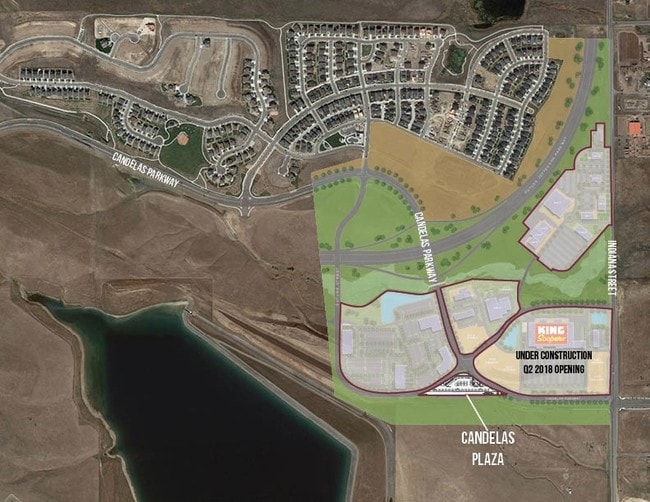
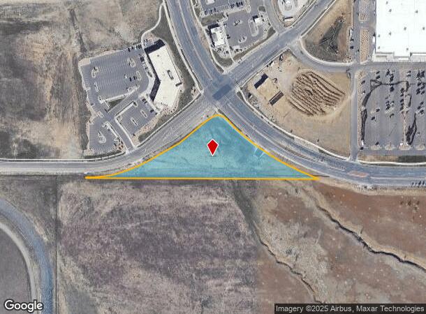
Vacant Land, Arvada, CO 80007
NEARBY LISTINGS FOR SALE OR LEASE
Property Detail
Vacant Land
Denver-Aurora-Centennial, CO
Candelas Medical Flg No 1
20-244-04-001
SECTION 24 TOWNSHIP 02 RANGE 70 SUBDIVISIONCD 108150 SUBDIVISIONNAME CANDELAS MEDICAL FLG NO 1 BLOCK 002 LOT 0001 SIZE: 110902 VALUE: 2.546
Pasture
Jefferson
X
Colorado
08059C0179F
1
2023
2.55 AC
2024
Northwest
009837
Denver
DEMOGRAPHICS near Vacant Land
1 Mile
3 Mile
5 Mile
2024 Total Population
4,263
31,147
113,633
2029 Population
4,248
30,850
112,511
Pop Growth 2024-2029
(0.35%)
(0.95%)
(0.99%)
Average Age
38
41
42
2024 Total Households
1,409
10,937
43,982
HH Growth 2024-2029
(0.57%)
(1.01%)
(0.89%)
Median Household Inc
$166,810
$147,208
$115,665
Avg Household Size
3.00
2.80
2.50
2024 Avg HH Vehicles
2.00
2.00
2.00
Median Home Value
$734,875
$714,836
$621,343
Median Year Built
2011
2003
1986
Nearby Places
Map Layers
Map Styles
 Street
 Aerial
- Restaurants
- Banks
- Shops
- Fitness
- Groceries
PUBLIC TRANSPORTATION
COMMUTER RAIL
DRIVE
WALK
Distance
13 min
7.0 mi
DRIVE
WALK
Distance
14 min
7.8 mi
AIRPORT
Denver International
DRIVE
WALK
Distance
Denver International
49 min
40.4 mi
SALE & LEASE HISTORY
LISTING DATE
SALE/LEASE

Aug 21, 2018
For Lease
Aug 03, 2017
For Lease
Nearby Properties
Address
Land Use
TOTAL SIZE
Lot Size
Zoning
Address
Land Use
TOTAL SIZE
Lot Size
Zoning
253,643 SF
50.87 AC
A2
Address
Land Use
TOTAL SIZE
Lot Size
Zoning
1,968.53 AC
Address
Land Use
TOTAL SIZE
Lot Size
Zoning
215,878 SF
11.82 AC
A2
Address
Land Use
TOTAL SIZE
Lot Size
Zoning
68,300 SF
6 AC
Address
Land Use
TOTAL SIZE
Lot Size
Zoning
110,235 SF
2.32 AC
Address
Land Use
TOTAL SIZE
Lot Size
Zoning
53,051 SF
70.19 AC
I2
Address
Land Use
TOTAL SIZE
Lot Size
Zoning
121,192 SF
12.43 AC
Address
Land Use
TOTAL SIZE
Lot Size
Zoning
95,412 SF
5.32 AC
Address
Land Use
TOTAL SIZE
Lot Size
Zoning
44,797 SF
4.35 AC
Address
Land Use
TOTAL SIZE
Lot Size
Zoning
89,535 SF
2.88 AC
Address
Land Use
TOTAL SIZE
Lot Size
Zoning
97,803 SF
10.02 AC
Address
Land Use
TOTAL SIZE
Lot Size
Zoning
441 AC
PD
Address
Land Use
TOTAL SIZE
Lot Size
Zoning
50,529 SF
23.88 AC
Address
Land Use
TOTAL SIZE
Lot Size
Zoning
43,403 SF
34.07 AC
Address
Land Use
TOTAL SIZE
Lot Size
Zoning
55,500 SF
3.99 AC
Address
Land Use
TOTAL SIZE
Lot Size
Zoning
76,908 SF
5.82 AC
Address
Land Use
TOTAL SIZE
Lot Size
Zoning
53,400 SF
6.40 AC
Address
Land Use
TOTAL SIZE
Lot Size
Zoning
320 AC
A2
Address
Land Use
TOTAL SIZE
Lot Size
Zoning
85.97 AC
A2
Address
Land Use
TOTAL SIZE
Lot Size
Zoning
295.40 AC
Address
Land Use
TOTAL SIZE
Lot Size
Zoning
23,906 SF
1.14 AC
Address
Land Use
TOTAL SIZE
Lot Size
Zoning
37,296 SF
8.45 AC
PD
Address
Land Use
TOTAL SIZE
Lot Size
Zoning
13,180 SF
2.86 AC
Address
Land Use
TOTAL SIZE
Lot Size
Zoning
13,050 SF
1.37 AC
Address
Land Use
TOTAL SIZE
Lot Size
Zoning
10,886 SF
1.47 AC
Address
Land Use
TOTAL SIZE
Lot Size
Zoning
14,677 SF
2.20 AC
Address
Land Use
TOTAL SIZE
Lot Size
Zoning
224.74 AC
Address
Land Use
TOTAL SIZE
Lot Size
Zoning
27,000 SF
1.95 AC
Address
Land Use
TOTAL SIZE
Lot Size
Zoning
28,308 SF
10.53 AC
MR1
Address
Land Use
TOTAL SIZE
Lot Size
Zoning
12,789 SF
1.83 AC
The World's #1 Commercial Real Estate Marketplace
Connect with us
© 2026 CoStar Group
The information above has been obtained from sources believed reliable. While we do not doubt its accuracy we have not verified it and make no guarantee, warranty or representation about it. It is your responsibility to independently confirm its accuracy and completeness. Any projections, opinions, assumptions, or estimates used are for example only and do not represent the current or future performance of the property. The value of this transaction to you depends on tax and other factors which should be evaluated by your tax, financial, and legal advisors. You and your advisors should conduct a careful, independent investigation of the property to determine to your satisfaction the suitability of the property for your needs.